
Station XC Y05 - Y05
Network: XC00 - Yellowstone Intermountain Seismic Array
Nearby stations (2 deg radius)
| Station | Name | (Lat, Lon) | Start / End | Elevation |
| Y05 | Y05 | (43.19, -111.58) | 2000-06-28 / 2001-12-31 | 1970 m |
| Crust2 Type: | M8,thick extended crust, 1.5 km seds. |
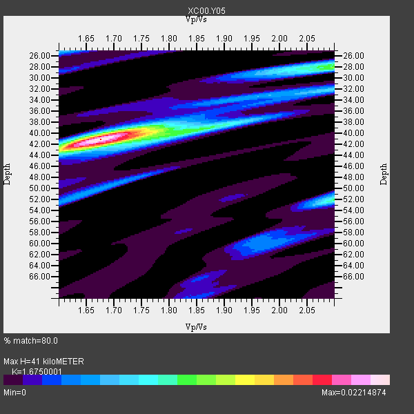
| Thickness Estimate: | 41 km |
| Thickness StdDev: | 3.8 km |
| Vp/Vs Estimate: | 1.68 |
| Vp/Vs StdDev: | 0.11 |
| Vs Estimate: | 3.706 km/s |
| Poisson's Ratio: | 0.22 |
| Peak Value: | 0.02 |
| Assumed Vp: | 6.207 km/s |
| Ps Weight: | 0.33333334 |
| PpPs Weight: | 0.33333334 |
| PsPs Weight: | 0.33333328 |
| Residual Complexity: | 0.545 |
| Nearby stations H: | +- |
| (2.0 deg) Vp/Vs: | +- |
5 with match > 90% ( 29.411764 %) and 17 with match > 80% ( 100.0 %) out of 17.
Download stack as xyz text file.
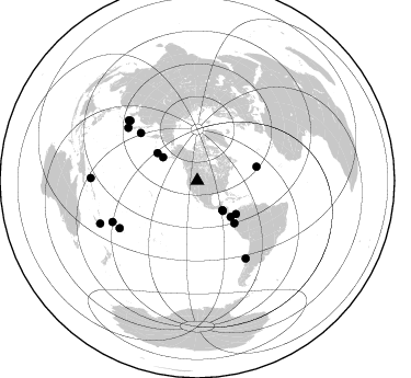
Azimuth Distribution of Events:
Prior Results for this Station
| Study | Thickness | Vp/Vs | Vp | Vs | Poissons Ratio | Extra |
| EARS | 41 km | 1.68 | 6.207 km/s | 3.706 km/s | 0.22 | |
| Crust2.0 | 37 km | 1.78 | 6.207 km/s | 3.489 km/s | 0.27 | M8,thick extended crust, 1.5 km seds. |
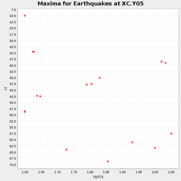
| Global Maxima | 41 km | 1.68 | 6.207 km/s | 3.706 km/s | 0.22 | amp=0.02214874 |
| Local Maxima 1 | 28 km | 2.10 | 6.207 km/s | 2.959 km/s | 0.35 | amp=0.0112575255 |
| Local Maxima 2 | 52 km | 2.10 | 6.207 km/s | 2.959 km/s | 0.35 | amp=0.010080106 |
| Local Maxima 3 | 40 km | 1.81 | 6.207 km/s | 3.429 km/s | 0.28 | amp=0.0087786075 |
| Local Maxima 4 | 32 km | 2.10 | 6.207 km/s | 2.963 km/s | 0.35 | amp=0.006778314 |
| Predicted Arrivals for vertical incidence (zero ray parameter) | |
| Ps | 4.46 SECOND |
| PpPs | 17.67 SECOND |
| PsPs/PpSs | 22.13 SECOND |
Events Processed for this Station
Download zip of receiver functions as SAC
Plot maxima for each earthquake.
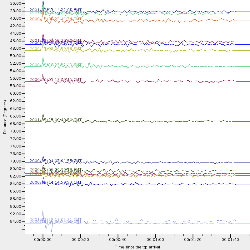
Events Used in the Stack
(17 events)| Radial Match | Distance | Baz | FERegion | Time | Lat/Lon | Depth | Magnitude |
| 94.77839 | 82.9 deg | 238.579 deg | Tonga Islands | 2000/09/26 06:17:52 GMT | (-17.2, -173.9) | 56 km | 6.1 MB, 6.1 MS, 6.4 MW, 6.1 ME |
| 93.97769 | 96.7 deg | 246.208 deg | Southeast Of Loyalty Islands | 2001/02/28 13:05:31 GMT | (-22.0, 170.1) | 10 km | 5.8 MB, 6.1 MS, 6.2 MW |
| 91.89369 | 35.3 deg | 139.617 deg | El Salvador | 2001/02/13 14:22:05 GMT | (13.7, -88.9) | 10 km | 5.5 MB, 6.5 MS, 6.6 MW, 6.1 MD |
| 91.821556 | 83.3 deg | 148.105 deg | Off Coast Of Central Chile | 2001/04/09 09:00:57 GMT | (-32.7, -73.1) | 11 km | 6.1 MB, 6.3 MS, 6.7 MW, 6.3 ME |
| 91.0591 | 36.0 deg | 139.727 deg | El Salvador | 2001/01/13 17:33:32 GMT | (13.0, -88.7) | 60 km | 6.4 MB, 7.8 MS, 7.7 MW, 7.5 ME |
| 89.375725 | 51.4 deg | 138.748 deg | Near Coast Of Ecuador | 2000/09/28 23:23:43 GMT | (-0.2, -80.6) | 23 km | 5.8 MB, 6.0 MS, 6.6 MW, 6.4 MW |
| 89.243706 | 97.3 deg | 271.364 deg | New Ireland Region, P.N.G. | 2000/11/16 04:54:56 GMT | (-4.0, 152.2) | 33 km | 6.0 MB, 8.2 MS, 8.0 MW, 8.0 ME |
| 88.47033 | 67.5 deg | 310.02 deg | Kuril Islands | 2001/05/25 00:40:50 GMT | (44.3, 148.4) | 33 km | 6.1 MB, 6.7 MS, 6.7 MW, 6.6 MW |
| 88.38944 | 79.5 deg | 307.312 deg | Near S. Coast Of Honshu, Japan | 2000/07/01 07:01:55 GMT | (34.2, 139.1) | 10 km | 6.0 MB, 6.1 MS, 6.2 MW, 6.2 MW |
| 87.539024 | 85.8 deg | 244.036 deg | Fiji Islands | 2000/09/14 14:59:57 GMT | (-15.7, 179.8) | 33 km | 5.7 MB, 6.2 MS, 6.3 MW, 6.2 MW |
| 86.87128 | 83.4 deg | 311.264 deg | Western Honshu, Japan | 2001/03/24 06:27:53 GMT | (34.1, 132.5) | 50 km | 6.4 MB, 6.5 MS, 6.8 MW, 6.4 ME |
| 86.31307 | 38.0 deg | 304.461 deg | Fox Islands, Aleutian Islands | 2000/12/05 22:11:34 GMT | (52.6, -167.8) | 33 km | 5.6 MB, 5.6 MS, 5.9 MW, 5.4 ML |
| 85.471275 | 44.2 deg | 304.811 deg | Andreanof Islands, Aleutian Is. | 2001/02/01 18:19:30 GMT | (51.4, -177.8) | 33 km | 5.6 MB, 5.6 MS, 6.0 MW, 5.9 MW |
| 82.475266 | 82.0 deg | 311.806 deg | Western Honshu, Japan | 2000/10/06 04:30:19 GMT | (35.5, 133.1) | 10 km | 5.8 MB, 6.8 MS, 7.0 ME, 6.7 MW |
| 82.359764 | 44.9 deg | 137.117 deg | South Of Panama | 2000/12/12 05:26:45 GMT | (6.0, -82.7) | 10 km | 5.8 MB, 5.7 MS, 6.3 ME, 6.1 MW |
| 82.211006 | 46.6 deg | 130.66 deg | Panama-Colombia Border Region | 2000/11/08 06:59:58 GMT | (7.0, -77.8) | 17 km | 6.0 MB, 6.4 MS, 6.5 MW, 6.2 ML |
| 81.2797 | 55.7 deg | 76.699 deg | Northern Mid-Atlantic Ridge | 2000/10/05 13:39:11 GMT | (31.7, -41.0) | 10 km | 5.4 MB, 6.1 MS, 6.0 MW, 5.9 MW |
Losers
(0 events)| Radial Match | Distance | Baz | FERegion | Time | Lat/Lon | Depth | Magnitude | Reason |
