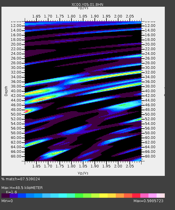
Y05 Y05 - Earthquake Result Viewer
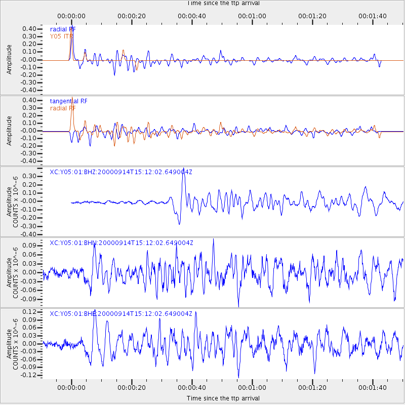
Earthquake location: Fiji Islands
Earthquake latitude/longitude: -15.7/179.8
Earthquake time(UTC): 2000/09/14 (258) 14:59:57 GMT
Earthquake Depth: 33 km
Earthquake Magnitude: 5.7 MB, 6.2 MS, 6.3 MW, 6.2 MW
Earthquake Catalog/Contributor: WHDF/NEIC
Network: XC Yellowstone Intermountain Seismic Array
Station: Y05 Y05
Lat/Lon: 43.19 N/111.58 W
Elevation: 1970 m
Distance: 85.8 deg
Az: 43.068 deg
Baz: 244.036 deg
Ray Param: 0.044449992
Estimated Moho Depth: 48.5 km
Estimated Crust Vp/Vs: 1.60
Assumed Crust Vp: 6.207 km/s
Estimated Crust Vs: 3.879 km/s
Estimated Crust Poisson's Ratio: 0.18
Radial Match: 87.539024 %
Radial Bump: 400
Transverse Match: 82.40816 %
Transverse Bump: 400
SOD ConfigId: 16820
Insert Time: 2010-02-26 15:02:42.510 +0000
GWidth: 2.5
Max Bumps: 400
Tol: 0.001

Signal To Noise

ChannelStoNSTALTA
XC:Y05:01:BHN:20000914T15:12:02.649004Z1.02043661.3786337E-81.3510233E-8
XC:Y05:01:BHE:20000914T15:12:02.649004Z0.822791041.2748213E-81.5493864E-8
XC:Y05:01:BHZ:20000914T15:12:02.649004Z4.8862285.3017235E-81.0850339E-8
Arrivals
Ps4.8 SECOND
PpPs20 SECOND
PsPs/PpSs25 SECOND