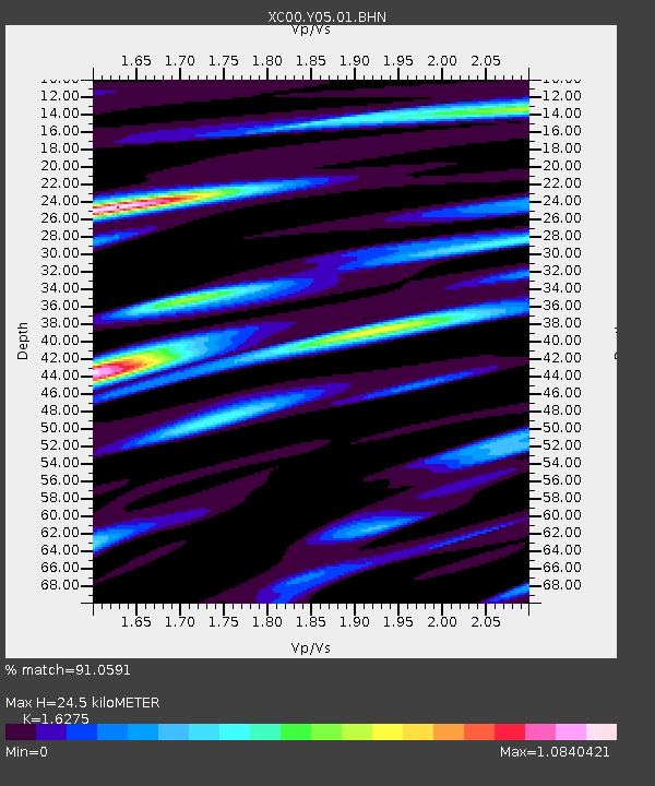
Y05 Y05 - Earthquake Result Viewer
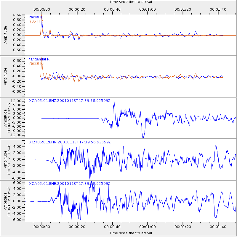
Earthquake location: El Salvador
Earthquake latitude/longitude: 13.0/-88.7
Earthquake time(UTC): 2001/01/13 (013) 17:33:32 GMT
Earthquake Depth: 60 km
Earthquake Magnitude: 6.4 MB, 7.8 MS, 7.7 MW, 7.5 ME
Earthquake Catalog/Contributor: WHDF/NEIC
Network: XC Yellowstone Intermountain Seismic Array
Station: Y05 Y05
Lat/Lon: 43.19 N/111.58 W
Elevation: 1970 m
Distance: 36.0 deg
Az: 330.977 deg
Baz: 139.727 deg
Ray Param: 0.07677763
Estimated Moho Depth: 24.5 km
Estimated Crust Vp/Vs: 1.63
Assumed Crust Vp: 6.207 km/s
Estimated Crust Vs: 3.814 km/s
Estimated Crust Poisson's Ratio: 0.20
Radial Match: 91.0591 %
Radial Bump: 391
Transverse Match: 83.26691 %
Transverse Bump: 400
SOD ConfigId: 16820
Insert Time: 2010-02-26 15:02:47.628 +0000
GWidth: 2.5
Max Bumps: 400
Tol: 0.001

Signal To Noise

ChannelStoNSTALTA
XC:Y05:01:BHN:20010113T17:39:56.92599Z2.6346671.11012525E-74.2135316E-8
XC:Y05:01:BHE:20010113T17:39:56.92599Z6.23795651.695724E-72.7183965E-8
XC:Y05:01:BHZ:20010113T17:39:56.92599Z10.2983574.8114435E-74.6720498E-8
Arrivals
Ps2.7 SECOND
PpPs9.6 SECOND
PsPs/PpSs12 SECOND