You are here: Home > Network List > XC00 - Yellowstone Intermountain Seismic Array Stations List
> Station Y05 Y05 > Earthquake Result Viewer
Y05 Y05 - Earthquake Result Viewer
| Earthquake location: |
Southeast Of Loyalty Islands |
| Earthquake latitude/longitude: |
-22.0/170.1 |
| Earthquake time(UTC): |
2001/02/28 (059) 13:05:31 GMT |
| Earthquake Depth: |
10 km |
| Earthquake Magnitude: |
5.8 MB, 6.1 MS, 6.2 MW |
| Earthquake Catalog/Contributor: |
WHDF/NEIC |
|
| Network: |
XC Yellowstone Intermountain Seismic Array |
| Station: |
Y05 Y05 |
| Lat/Lon: |
43.19 N/111.58 W |
| Elevation: |
1970 m |
|
| Distance: |
96.7 deg |
| Az: |
46.148 deg |
| Baz: |
246.208 deg |
| Ray Param: |
0.040440302 |
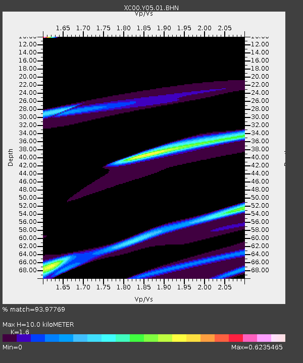
| Estimated Moho Depth: |
10.0 km |
| Estimated Crust Vp/Vs: |
1.60 |
| Assumed Crust Vp: |
6.207 km/s |
| Estimated Crust Vs: |
3.879 km/s |
| Estimated Crust Poisson's Ratio: |
0.18 |
|
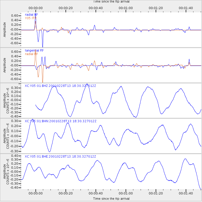
| Radial Match: |
93.97769 % |
| Radial Bump: |
369 |
| Transverse Match: |
75.53397 % |
| Transverse Bump: |
400 |
| SOD ConfigId: |
3744 |
| Insert Time: |
2010-02-26 15:02:51.170 +0000 |
| GWidth: |
2.5 |
| Max Bumps: |
400 |
| Tol: |
0.001 |
|
Signal To Noise
| Channel | StoN | STA | LTA |
| XC:Y05:01:BHN:20010228T13:18:30.327012Z | 0.7140165 | 1.2587799E-7 | 1.7629563E-7 |
| XC:Y05:01:BHE:20010228T13:18:30.327012Z | 0.90301305 | 1.02267315E-7 | 1.13251204E-7 |
| XC:Y05:01:BHZ:20010228T13:18:30.327012Z | 1.1768781 | 2.6901577E-7 | 2.2858423E-7 |
| Arrivals |
| Ps | 1.0 SECOND |
| PpPs | 4.1 SECOND |
| PsPs/PpSs | 5.1 SECOND |


