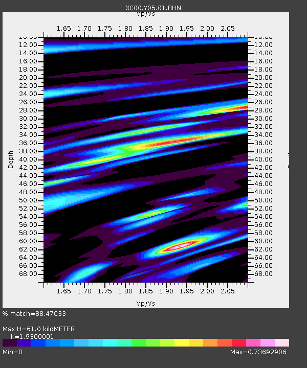
Y05 Y05 - Earthquake Result Viewer
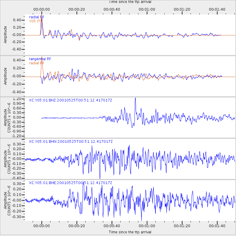
Earthquake location: Kuril Islands
Earthquake latitude/longitude: 44.3/148.4
Earthquake time(UTC): 2001/05/25 (145) 00:40:50 GMT
Earthquake Depth: 33 km
Earthquake Magnitude: 6.1 MB, 6.7 MS, 6.7 MW, 6.6 MW
Earthquake Catalog/Contributor: WHDF/NEIC
Network: XC Yellowstone Intermountain Seismic Array
Station: Y05 Y05
Lat/Lon: 43.19 N/111.58 W
Elevation: 1970 m
Distance: 67.5 deg
Az: 51.229 deg
Baz: 310.02 deg
Ray Param: 0.05687396
Estimated Moho Depth: 61.0 km
Estimated Crust Vp/Vs: 1.93
Assumed Crust Vp: 6.207 km/s
Estimated Crust Vs: 3.216 km/s
Estimated Crust Poisson's Ratio: 0.32
Radial Match: 88.47033 %
Radial Bump: 400
Transverse Match: 87.363335 %
Transverse Bump: 400
SOD ConfigId: 4714
Insert Time: 2010-02-26 15:02:52.833 +0000
GWidth: 2.5
Max Bumps: 400
Tol: 0.001

Signal To Noise

ChannelStoNSTALTA
XC:Y05:01:BHN:20010525T00:51:12.417017Z1.02406022.107136E-82.057629E-8
XC:Y05:01:BHE:20010525T00:51:12.417017Z1.56131483.225191E-82.0656891E-8
XC:Y05:01:BHZ:20010525T00:51:12.417017Z3.0626052.4264315E-87.92277E-9
Arrivals
Ps9.5 SECOND
PpPs28 SECOND
PsPs/PpSs37 SECOND