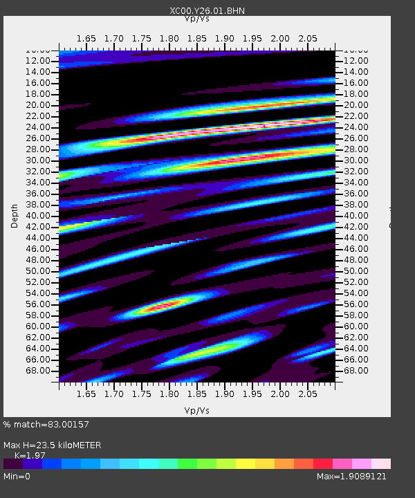
Y26 Y26 - Earthquake Result Viewer
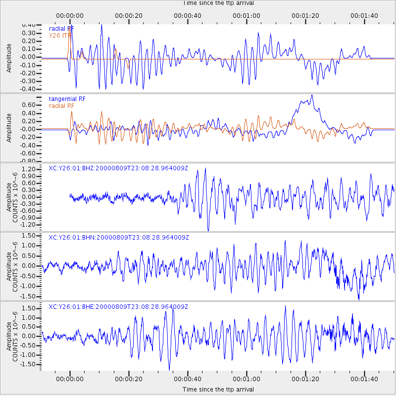
Earthquake location: Fiji Islands Region
Earthquake latitude/longitude: -16.8/174.3
Earthquake time(UTC): 2000/08/09 (222) 22:55:59 GMT
Earthquake Depth: 33 km
Earthquake Magnitude: 5.7 MB, 6.3 MS, 6.4 MW, 6.4 MW
Earthquake Catalog/Contributor: WHDF/NEIC
Network: XC Yellowstone Intermountain Seismic Array
Station: Y26 Y26
Lat/Lon: 45.45 N/111.75 W
Elevation: 1529 m
Distance: 91.0 deg
Az: 42.57 deg
Baz: 247.002 deg
Ray Param: 0.041630317
Estimated Moho Depth: 23.5 km
Estimated Crust Vp/Vs: 1.97
Assumed Crust Vp: 6.35 km/s
Estimated Crust Vs: 3.223 km/s
Estimated Crust Poisson's Ratio: 0.33
Radial Match: 83.00157 %
Radial Bump: 400
Transverse Match: 66.640274 %
Transverse Bump: 400
SOD ConfigId: 3744
Insert Time: 2010-02-26 15:02:57.471 +0000
GWidth: 2.5
Max Bumps: 400
Tol: 0.001

Signal To Noise

ChannelStoNSTALTA
XC:Y26:01:BHN:20000809T23:08:28.964009Z0.913444761.2727716E-71.3933756E-7
XC:Y26:01:BHE:20000809T23:08:28.964009Z1.55596651.9576954E-71.2581862E-7
XC:Y26:01:BHZ:20000809T23:08:28.964009Z1.29616991.305693E-71.0073472E-7
Arrivals
Ps3.7 SECOND
PpPs11 SECOND
PsPs/PpSs14 SECOND