
Station XC Y26 - Y26
Network: XC00 - Yellowstone Intermountain Seismic Array
Nearby stations (2 deg radius)
| Station | Name | (Lat, Lon) | Start / End | Elevation |
| Y26 | Y26 | (45.45, -111.75) | 2000-08-07 / 2001-12-31 | 1529 m |
| Crust2 Type: | P6,orogen/43km, Orogen, 0.5 km seds. |
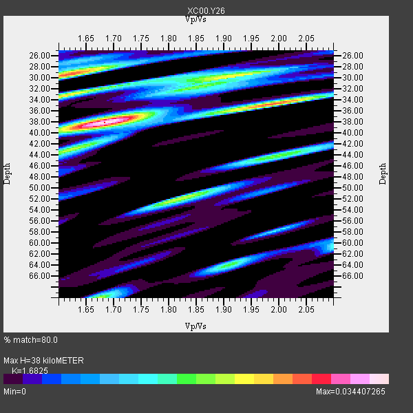
| Thickness Estimate: | 38 km |
| Thickness StdDev: | 6.7 km |
| Vp/Vs Estimate: | 1.68 |
| Vp/Vs StdDev: | 0.14 |
| Vs Estimate: | 3.774 km/s |
| Poisson's Ratio: | 0.23 |
| Peak Value: | 0.03 |
| Assumed Vp: | 6.35 km/s |
| Ps Weight: | 0.33333334 |
| PpPs Weight: | 0.33333334 |
| PsPs Weight: | 0.33333328 |
| Residual Complexity: | 0.757 |
| Nearby stations H: | +- |
| (2.0 deg) Vp/Vs: | +- |
0 with match > 90% ( 0.0 %) and 6 with match > 80% ( 100.0 %) out of 6.
Download stack as xyz text file.
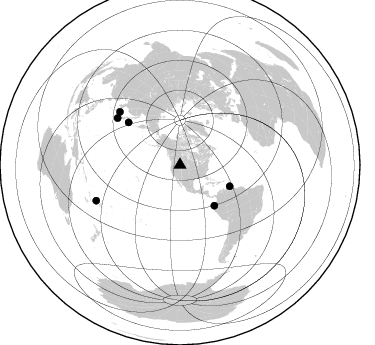
Azimuth Distribution of Events:
Prior Results for this Station
| Study | Thickness | Vp/Vs | Vp | Vs | Poissons Ratio | Extra |
| EARS | 38 km | 1.68 | 6.35 km/s | 3.774 km/s | 0.23 | |
| Crust2.0 | 43 km | 1.76 | 6.35 km/s | 3.609 km/s | 0.26 | P6,orogen/43km, Orogen, 0.5 km seds. |
| Global Maxima | 38 km | 1.68 | 6.35 km/s | 3.774 km/s | 0.23 | amp=0.034407265 |
| Local Maxima 1 | 29 km | 1.62 | 6.35 km/s | 3.926 km/s | 0.19 | amp=0.027093006 |
| Local Maxima 2 | 30 km | 1.92 | 6.35 km/s | 3.303 km/s | 0.31 | amp=0.021263983 |
| Local Maxima 3 | 35 km | 1.97 | 6.35 km/s | 3.227 km/s | 0.33 | amp=0.020873444 |
| Local Maxima 4 | 52 km | 1.81 | 6.35 km/s | 3.503 km/s | 0.28 | amp=0.020637516 |
| Predicted Arrivals for vertical incidence (zero ray parameter) | |
| Ps | 4.08 SECOND |
| PpPs | 16.05 SECOND |
| PsPs/PpSs | 20.14 SECOND |
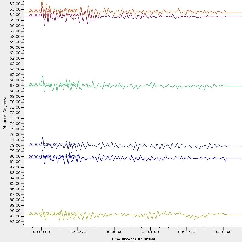
Events Processed for this Station
Download zip of receiver functions as SAC
Plot maxima for each earthquake.
Events Used in the Stack
(6 events)| Radial Match | Distance | Baz | FERegion | Time | Lat/Lon | Depth | Magnitude |
| 88.71668 | 53.2 deg | 139.704 deg | Near Coast Of Ecuador | 2000/09/28 23:23:43 GMT | (-0.2, -80.6) | 23 km | 5.8 MB, 6.0 MS, 6.6 MW, 6.4 MW |
| 88.16165 | 54.0 deg | 113.347 deg | Windward Islands | 2000/10/04 14:37:44 GMT | (11.1, -62.6) | 110 km | 5.6 MB, 5.4 MS, 6.1 MW, 5.9 MD |
| 86.639366 | 66.9 deg | 309.447 deg | Kuril Islands | 2000/08/19 17:26:27 GMT | (43.8, 147.2) | 62 km | 6.0 MB, 5.8 MW, 5.7 MW |
| 83.00157 | 91.0 deg | 247.002 deg | Fiji Islands Region | 2000/08/09 22:55:59 GMT | (-16.8, 174.3) | 33 km | 5.7 MB, 6.3 MS, 6.4 MW, 6.4 MW |
| 81.93535 | 78.1 deg | 306.758 deg | Near S. Coast Of Honshu, Japan | 2000/08/18 01:52:20 GMT | (34.1, 139.2) | 10 km | 5.6 MB, 5.5 MS, 5.8 MW, 5.7 MW |
| 80.02092 | 80.4 deg | 311.441 deg | Western Honshu, Japan | 2000/10/06 04:30:19 GMT | (35.5, 133.1) | 10 km | 5.8 MB, 6.8 MS, 7.0 ME, 6.7 MW |
Losers
(0 events)| Radial Match | Distance | Baz | FERegion | Time | Lat/Lon | Depth | Magnitude | Reason |
