You are here: Home > Network List > XC00 - Yellowstone Intermountain Seismic Array Stations List
> Station Y26 Y26 > Earthquake Result Viewer
Y26 Y26 - Earthquake Result Viewer
| Earthquake location: |
Kuril Islands |
| Earthquake latitude/longitude: |
43.8/147.2 |
| Earthquake time(UTC): |
2000/08/19 (232) 17:26:27 GMT |
| Earthquake Depth: |
62 km |
| Earthquake Magnitude: |
6.0 MB, 5.8 MW, 5.7 MW |
| Earthquake Catalog/Contributor: |
WHDF/NEIC |
|
| Network: |
XC Yellowstone Intermountain Seismic Array |
| Station: |
Y26 Y26 |
| Lat/Lon: |
45.45 N/111.75 W |
| Elevation: |
1529 m |
|
| Distance: |
66.9 deg |
| Az: |
48.671 deg |
| Baz: |
309.447 deg |
| Ray Param: |
0.05715535 |
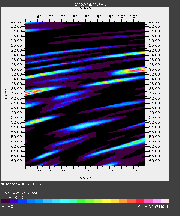
| Estimated Moho Depth: |
29.75 km |
| Estimated Crust Vp/Vs: |
2.10 |
| Assumed Crust Vp: |
6.35 km/s |
| Estimated Crust Vs: |
3.027 km/s |
| Estimated Crust Poisson's Ratio: |
0.35 |
|
| Radial Match: |
86.639366 % |
| Radial Bump: |
400 |
| Transverse Match: |
83.86388 % |
| Transverse Bump: |
400 |
| SOD ConfigId: |
16820 |
| Insert Time: |
2010-02-26 15:02:59.478 +0000 |
| GWidth: |
2.5 |
| Max Bumps: |
400 |
| Tol: |
0.001 |
|
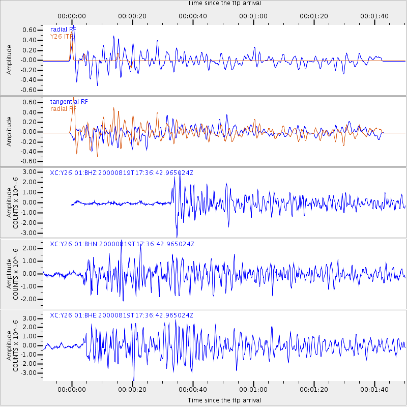
Signal To Noise
| Channel | StoN | STA | LTA |
| XC:Y26:01:BHN:20000819T17:36:42.965024Z | 1.573488 | 2.5344258E-7 | 1.6107056E-7 |
| XC:Y26:01:BHE:20000819T17:36:42.965024Z | 1.6399499 | 3.5073225E-7 | 2.1386766E-7 |
| XC:Y26:01:BHZ:20000819T17:36:42.965024Z | 10.540873 | 1.0062794E-6 | 9.546452E-8 |
| Arrivals |
| Ps | 5.3 SECOND |
| PpPs | 14 SECOND |
| PsPs/PpSs | 19 SECOND |


