Y61 Y61 - Earthquake Result Viewer
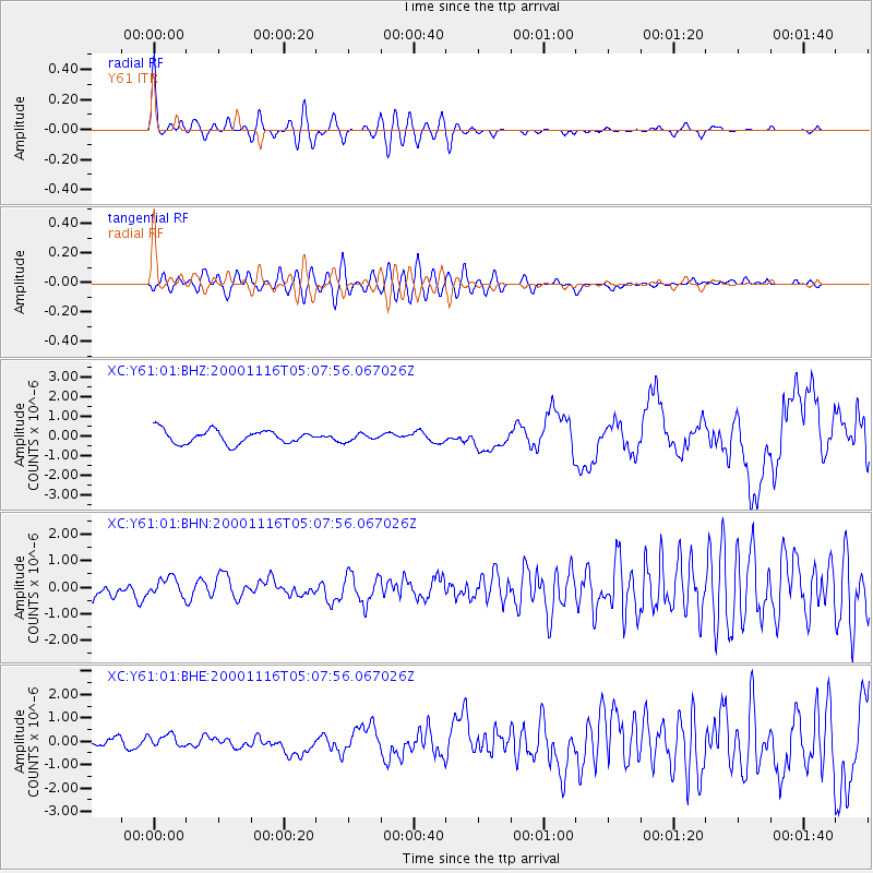
Earthquake location: New Ireland Region, P.N.G.
Earthquake latitude/longitude: -4.0/152.2
Earthquake time(UTC): 2000/11/16 (321) 04:54:56 GMT
Earthquake Depth: 33 km
Earthquake Magnitude: 6.0 MB, 8.2 MS, 8.0 MW, 8.0 ME
Earthquake Catalog/Contributor: WHDF/NEIC
Network: XC Yellowstone Intermountain Seismic Array
Station: Y61 Y61
Lat/Lon: 46.60 N/111.03 W
Elevation: 1510 m
Distance: 97.6 deg
Az: 43.686 deg
Baz: 272.199 deg
Ray Param: 0.040163852
Estimated Moho Depth: 55.75 km
Estimated Crust Vp/Vs: 1.68
Assumed Crust Vp: 6.306 km/s
Estimated Crust Vs: 3.759 km/s
Estimated Crust Poisson's Ratio: 0.22
Radial Match: 81.696236 %
Radial Bump: 400
Transverse Match: 53.28014 %
Transverse Bump: 400
SOD ConfigId: 3744
Insert Time: 2010-02-26 15:03:03.036 +0000
GWidth: 2.5
Max Bumps: 400
Tol: 0.001

Signal To Noise

ChannelStoNSTALTA
XC:Y61:01:BHN:20001116T05:07:56.067026Z0.75293843.2375274E-74.299857E-7
XC:Y61:01:BHE:20001116T05:07:56.067026Z0.864826742.4272427E-72.806623E-7
XC:Y61:01:BHZ:20001116T05:07:56.067026Z0.565743451.9310154E-73.4132353E-7
Arrivals
Ps6.1 SECOND
PpPs23 SECOND
PsPs/PpSs29 SECOND