
Station XC Y61 - Y61
Network: XC00 - Yellowstone Intermountain Seismic Array
Nearby stations (2 deg radius)
| Station | Name | (Lat, Lon) | Start / End | Elevation |
| Y61 | Y61 | (46.60, -111.03) | 2000-08-06 / 2001-12-31 | 1510 m |
| Crust2 Type: | P4,orogen/50km, Urals, Tethian Orogen, Rockies 1 km seds. |
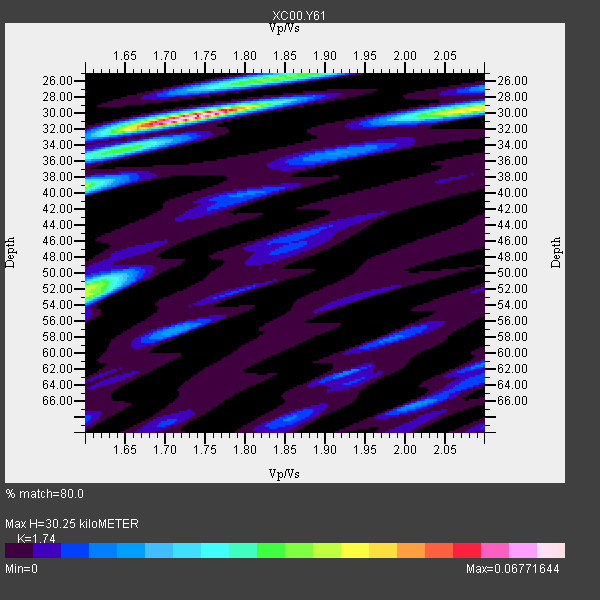
| Thickness Estimate: | 30 km |
| Thickness StdDev: | 11 km |
| Vp/Vs Estimate: | 1.74 |
| Vp/Vs StdDev: | 0.12 |
| Vs Estimate: | 3.624 km/s |
| Poisson's Ratio: | 0.25 |
| Peak Value: | 0.07 |
| Assumed Vp: | 6.306 km/s |
| Ps Weight: | 0.33333334 |
| PpPs Weight: | 0.33333334 |
| PsPs Weight: | 0.33333328 |
| Residual Complexity: | 0.637 |
| Nearby stations H: | +- |
| (2.0 deg) Vp/Vs: | +- |
1 with match > 90% ( 20.0 %) and 5 with match > 80% ( 100.0 %) out of 5.
Download stack as xyz text file.
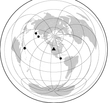
Azimuth Distribution of Events:
Prior Results for this Station
| Study | Thickness | Vp/Vs | Vp | Vs | Poissons Ratio | Extra |
| EARS | 30 km | 1.74 | 6.306 km/s | 3.624 km/s | 0.25 | |
| Crust2.0 | 50 km | 1.76 | 6.306 km/s | 3.584 km/s | 0.26 | P4,orogen/50km, Urals, Tethian Orogen, Rockies 1 km seds. |
| Global Maxima | 30 km | 1.74 | 6.306 km/s | 3.624 km/s | 0.25 | amp=0.06771644 |
| Local Maxima 1 | 29 km | 2.09 | 6.306 km/s | 3.017 km/s | 0.35 | amp=0.044680115 |
| Local Maxima 2 | 39 km | 1.60 | 6.306 km/s | 3.941 km/s | 0.18 | amp=0.03542833 |
| Local Maxima 3 | 53 km | 1.60 | 6.306 km/s | 3.941 km/s | 0.18 | amp=0.032042146 |
| Local Maxima 4 | 26 km | 1.82 | 6.306 km/s | 3.46 km/s | 0.28 | amp=0.02251141 |
| Predicted Arrivals for vertical incidence (zero ray parameter) | |
| Ps | 3.55 SECOND |
| PpPs | 13.14 SECOND |
| PsPs/PpSs | 16.69 SECOND |
Events Processed for this Station
Download zip of receiver functions as SAC
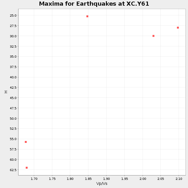
Plot maxima for each earthquake.
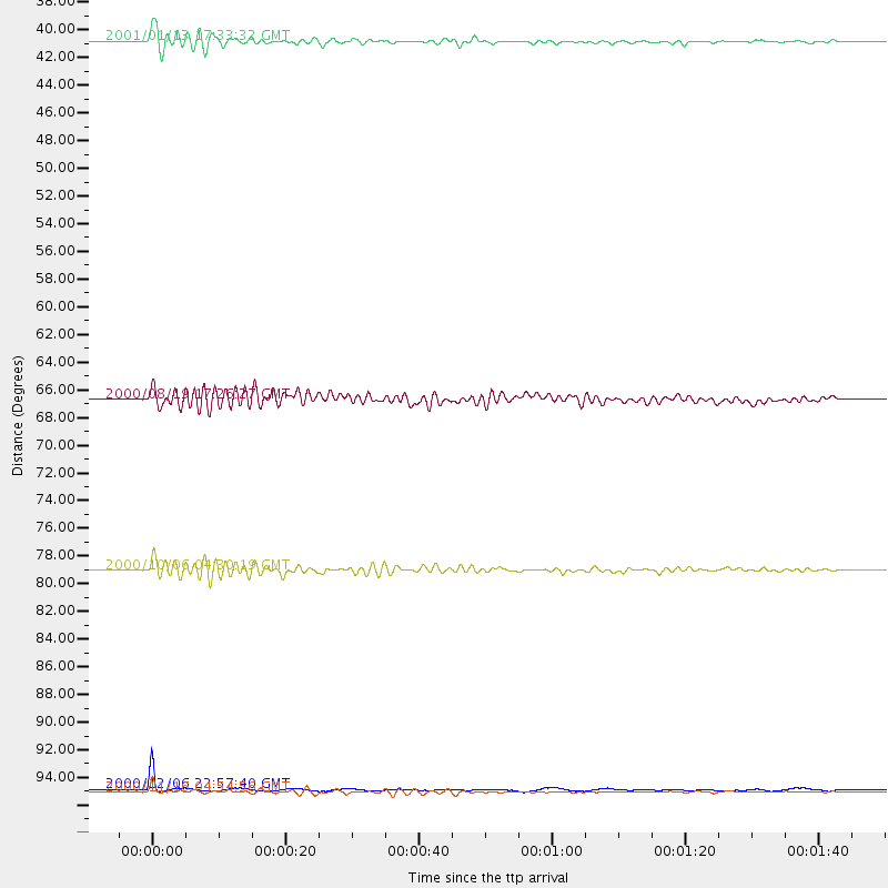
Events Used in the Stack
(5 events)| Radial Match | Distance | Baz | FERegion | Time | Lat/Lon | Depth | Magnitude |
| 92.83927 | 97.3 deg | 271.63 deg | New Britain Region, P.N.G. | 2000/12/06 22:57:40 GMT | (-4.2, 152.7) | 31 km | 6.1 MB, 6.6 MS, 6.6 MW, 6.2 ME |
| 85.66778 | 80.0 deg | 311.754 deg | Western Honshu, Japan | 2000/10/06 04:30:19 GMT | (35.5, 133.1) | 10 km | 5.8 MB, 6.8 MS, 7.0 ME, 6.7 MW |
| 85.57614 | 38.4 deg | 143.322 deg | El Salvador | 2001/01/13 17:33:32 GMT | (13.0, -88.7) | 60 km | 6.4 MB, 7.8 MS, 7.7 MW, 7.5 ME |
| 83.156456 | 66.6 deg | 309.447 deg | Kuril Islands | 2000/08/19 17:26:27 GMT | (43.8, 147.2) | 62 km | 6.0 MB, 5.8 MW, 5.7 MW |
| 81.696236 | 97.6 deg | 272.199 deg | New Ireland Region, P.N.G. | 2000/11/16 04:54:56 GMT | (-4.0, 152.2) | 33 km | 6.0 MB, 8.2 MS, 8.0 MW, 8.0 ME |
Losers
(0 events)| Radial Match | Distance | Baz | FERegion | Time | Lat/Lon | Depth | Magnitude | Reason |
