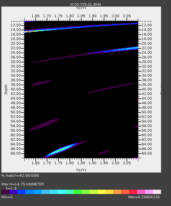
Y25 Y25 - Earthquake Result Viewer
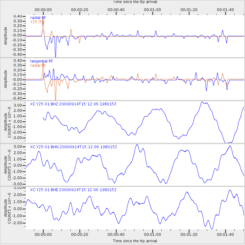
Earthquake location: Fiji Islands
Earthquake latitude/longitude: -15.7/179.8
Earthquake time(UTC): 2000/09/14 (258) 14:59:57 GMT
Earthquake Depth: 33 km
Earthquake Magnitude: 5.7 MB, 6.2 MS, 6.3 MW, 6.2 MW
Earthquake Catalog/Contributor: WHDF/NEIC
Network: XC Yellowstone Intermountain Seismic Array
Station: Y25 Y25
Lat/Lon: 45.71 N/112.18 W
Elevation: 1393 m
Distance: 86.5 deg
Az: 40.614 deg
Baz: 243.453 deg
Ray Param: 0.04393095
Estimated Moho Depth: 14.75 km
Estimated Crust Vp/Vs: 1.60
Assumed Crust Vp: 6.577 km/s
Estimated Crust Vs: 4.111 km/s
Estimated Crust Poisson's Ratio: 0.18
Radial Match: 92.883095 %
Radial Bump: 398
Transverse Match: 74.270966 %
Transverse Bump: 400
SOD ConfigId: 16820
Insert Time: 2010-02-26 15:03:15.988 +0000
GWidth: 2.5
Max Bumps: 400
Tol: 0.001

Signal To Noise

ChannelStoNSTALTA
XC:Y25:01:BHN:20000914T15:12:06.198015Z1.22023886.626916E-75.4308356E-7
XC:Y25:01:BHE:20000914T15:12:06.198015Z0.63705064.118379E-76.4647594E-7
XC:Y25:01:BHZ:20000914T15:12:06.198015Z2.05446362.1954088E-61.0686043E-6
Arrivals
Ps1.4 SECOND
PpPs5.7 SECOND
PsPs/PpSs7.1 SECOND