
Station XC Y25 - Y25
Network: XC00 - Yellowstone Intermountain Seismic Array
Nearby stations (2 deg radius)
| Station | Name | (Lat, Lon) | Start / End | Elevation |
| Y25 | Y25 | (45.71, -112.18) | 2000-07-09 / 2001-12-31 | 1393 m |
| Crust2 Type: | H3,early/mid Proter. shield, Finland, 0.5 km seds. |
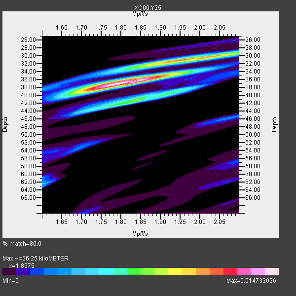
| Thickness Estimate: | 36 km |
| Thickness StdDev: | 11 km |
| Vp/Vs Estimate: | 1.84 |
| Vp/Vs StdDev: | 0.12 |
| Vs Estimate: | 3.579 km/s |
| Poisson's Ratio: | 0.29 |
| Peak Value: | 0.01 |
| Assumed Vp: | 6.577 km/s |
| Ps Weight: | 0.33333334 |
| PpPs Weight: | 0.33333334 |
| PsPs Weight: | 0.33333328 |
| Residual Complexity: | 0.572 |
| Nearby stations H: | +- |
| (2.0 deg) Vp/Vs: | +- |
3 with match > 90% ( 37.5 %) and 8 with match > 80% ( 100.0 %) out of 8.
Download stack as xyz text file.
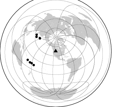
Azimuth Distribution of Events:
Prior Results for this Station
| Study | Thickness | Vp/Vs | Vp | Vs | Poissons Ratio | Extra |
| EARS | 36 km | 1.84 | 6.577 km/s | 3.579 km/s | 0.29 | |
| Crust2.0 | 46 km | 1.78 | 6.577 km/s | 3.701 km/s | 0.27 | H3,early/mid Proter. shield, Finland, 0.5 km seds. |
| Global Maxima | 36 km | 1.84 | 6.577 km/s | 3.579 km/s | 0.29 | amp=0.014732026 |
| Local Maxima 1 | 30 km | 2.07 | 6.577 km/s | 3.185 km/s | 0.35 | amp=0.009236424 |
| Local Maxima 2 | 41 km | 1.85 | 6.577 km/s | 3.555 km/s | 0.29 | amp=0.0071494374 |
| Local Maxima 3 | 39 km | 1.71 | 6.577 km/s | 3.841 km/s | 0.24 | amp=0.0061000367 |
| Local Maxima 4 | 32 km | 1.87 | 6.577 km/s | 3.527 km/s | 0.30 | amp=0.0047777854 |
| Predicted Arrivals for vertical incidence (zero ray parameter) | |
| Ps | 4.62 SECOND |
| PpPs | 15.64 SECOND |
| PsPs/PpSs | 20.26 SECOND |
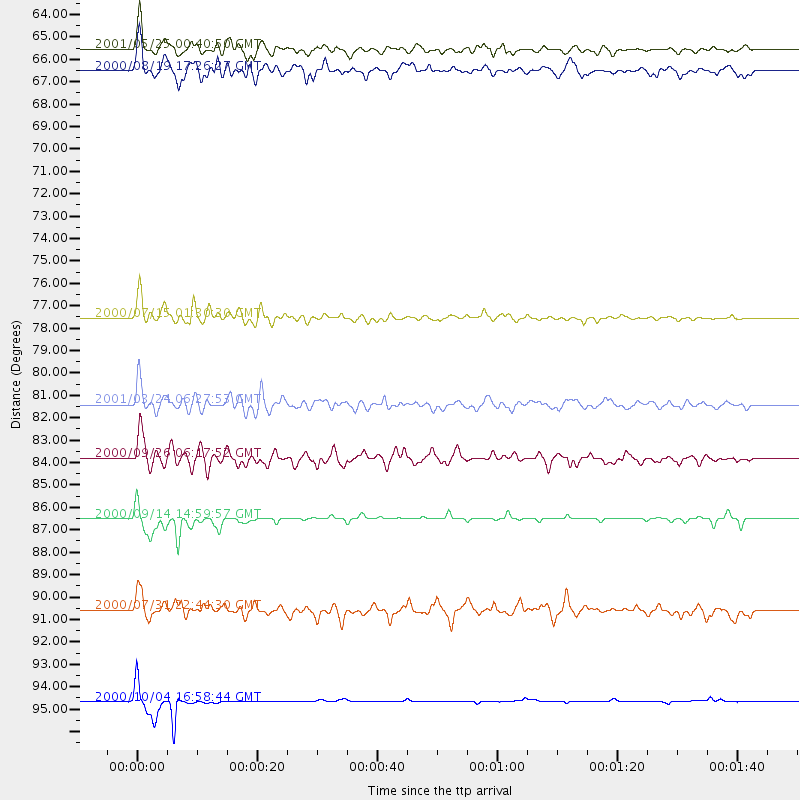
Events Processed for this Station
Download zip of receiver functions as SAC
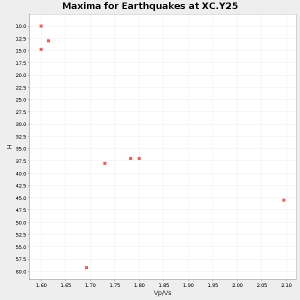
Plot maxima for each earthquake.
Events Used in the Stack
(8 events)| Radial Match | Distance | Baz | FERegion | Time | Lat/Lon | Depth | Magnitude |
| 98.57475 | 94.7 deg | 252.848 deg | Vanuatu Islands | 2000/10/04 16:58:44 GMT | (-15.4, 166.9) | 23 km | 6.1 MB, 6.9 MS, 6.8 MW, 6.5 ME |
| 92.883095 | 86.5 deg | 243.453 deg | Fiji Islands | 2000/09/14 14:59:57 GMT | (-15.7, 179.8) | 33 km | 5.7 MB, 6.2 MS, 6.3 MW, 6.2 MW |
| 90.91103 | 81.4 deg | 310.629 deg | Western Honshu, Japan | 2001/03/24 06:27:53 GMT | (34.1, 132.5) | 50 km | 6.4 MB, 6.5 MS, 6.8 MW, 6.4 ME |
| 88.62538 | 77.5 deg | 306.527 deg | Near S. Coast Of Honshu, Japan | 2000/07/15 01:30:30 GMT | (34.3, 139.3) | 10 km | 5.5 MB, 5.9 MS, 6.1 MW, 6.0 MW |
| 88.02599 | 65.6 deg | 308.875 deg | Kuril Islands | 2001/05/25 00:40:50 GMT | (44.3, 148.4) | 33 km | 6.1 MB, 6.7 MS, 6.7 MW, 6.6 MW |
| 87.36627 | 83.8 deg | 237.883 deg | Tonga Islands | 2000/09/26 06:17:52 GMT | (-17.2, -173.9) | 56 km | 6.1 MB, 6.1 MS, 6.4 MW, 6.1 ME |
| 83.55224 | 66.5 deg | 309.136 deg | Kuril Islands | 2000/08/19 17:26:27 GMT | (43.8, 147.2) | 62 km | 6.0 MB, 5.8 MW, 5.7 MW |
| 81.92058 | 90.6 deg | 246.617 deg | Fiji Islands Region | 2000/07/31 22:44:30 GMT | (-16.7, 174.5) | 10 km | 5.7 MB, 5.6 MS, 6.1 MW, 6.1 MW |
Losers
(0 events)| Radial Match | Distance | Baz | FERegion | Time | Lat/Lon | Depth | Magnitude | Reason |
