You are here: Home > Network List > XC00 - Yellowstone Intermountain Seismic Array Stations List
> Station Y25 Y25 > Earthquake Result Viewer
Y25 Y25 - Earthquake Result Viewer
| Earthquake location: |
Kuril Islands |
| Earthquake latitude/longitude: |
43.8/147.2 |
| Earthquake time(UTC): |
2000/08/19 (232) 17:26:27 GMT |
| Earthquake Depth: |
62 km |
| Earthquake Magnitude: |
6.0 MB, 5.8 MW, 5.7 MW |
| Earthquake Catalog/Contributor: |
WHDF/NEIC |
|
| Network: |
XC Yellowstone Intermountain Seismic Array |
| Station: |
Y25 Y25 |
| Lat/Lon: |
45.71 N/112.18 W |
| Elevation: |
1393 m |
|
| Distance: |
66.5 deg |
| Az: |
48.663 deg |
| Baz: |
309.136 deg |
| Ray Param: |
0.057419274 |
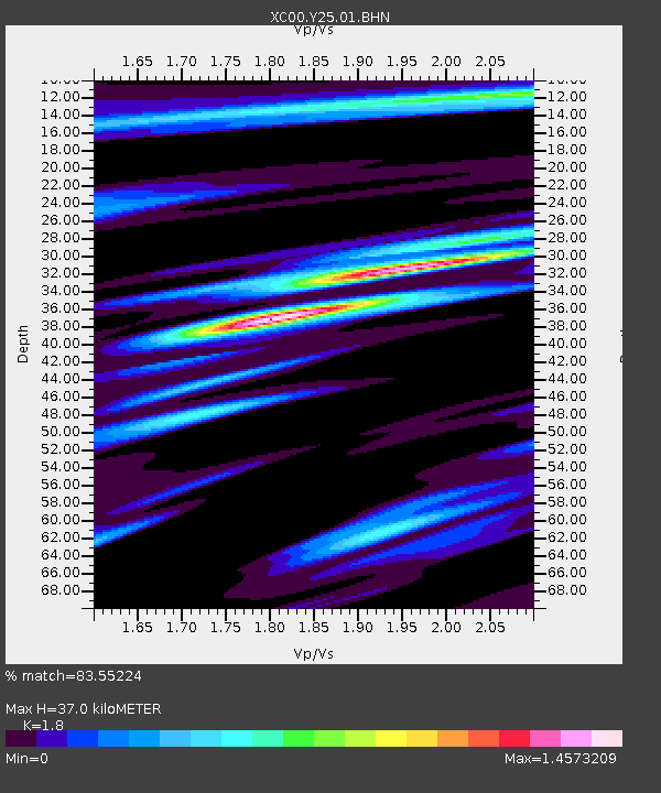
| Estimated Moho Depth: |
37.0 km |
| Estimated Crust Vp/Vs: |
1.80 |
| Assumed Crust Vp: |
6.577 km/s |
| Estimated Crust Vs: |
3.654 km/s |
| Estimated Crust Poisson's Ratio: |
0.28 |
|
| Radial Match: |
83.55224 % |
| Radial Bump: |
400 |
| Transverse Match: |
62.261288 % |
| Transverse Bump: |
400 |
| SOD ConfigId: |
16820 |
| Insert Time: |
2010-02-26 15:03:17.505 +0000 |
| GWidth: |
2.5 |
| Max Bumps: |
400 |
| Tol: |
0.001 |
|
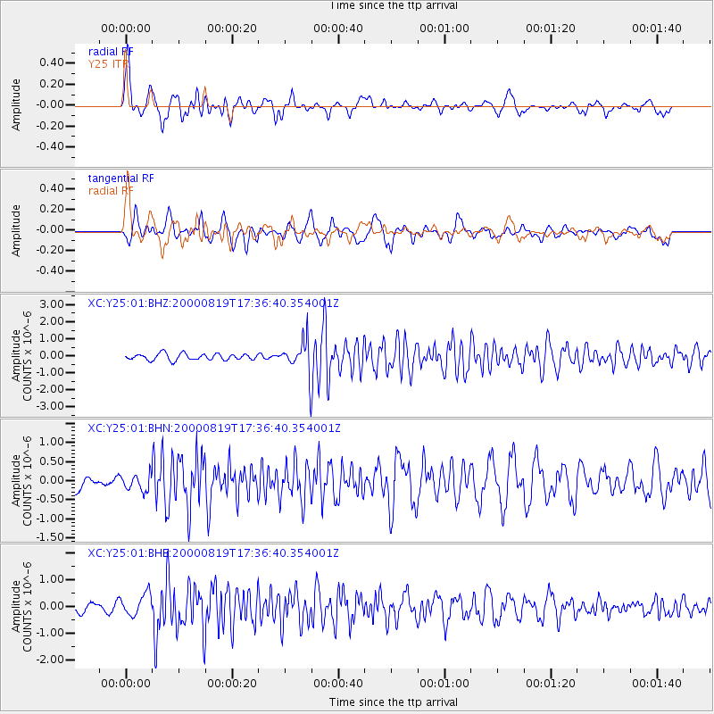
Signal To Noise
| Channel | StoN | STA | LTA |
| XC:Y25:01:BHN:20000819T17:36:40.354001Z | 0.7572067 | 2.057927E-7 | 2.7177876E-7 |
| XC:Y25:01:BHE:20000819T17:36:40.354001Z | 2.286551 | 4.1124062E-7 | 1.7985194E-7 |
| XC:Y25:01:BHZ:20000819T17:36:40.354001Z | 4.8394403 | 9.0587156E-7 | 1.8718518E-7 |
| Arrivals |
| Ps | 4.7 SECOND |
| PpPs | 15 SECOND |
| PsPs/PpSs | 20 SECOND |


