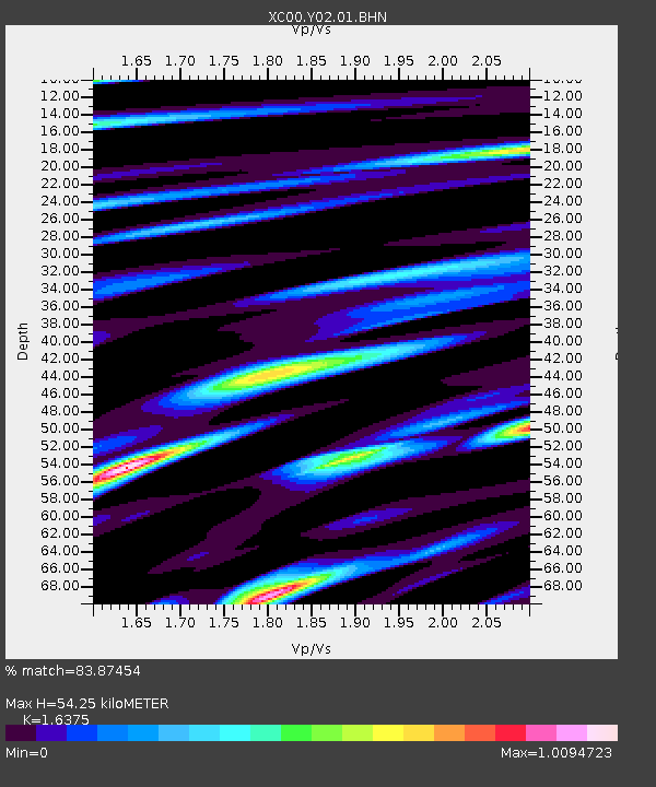
Y02 Y02 - Earthquake Result Viewer
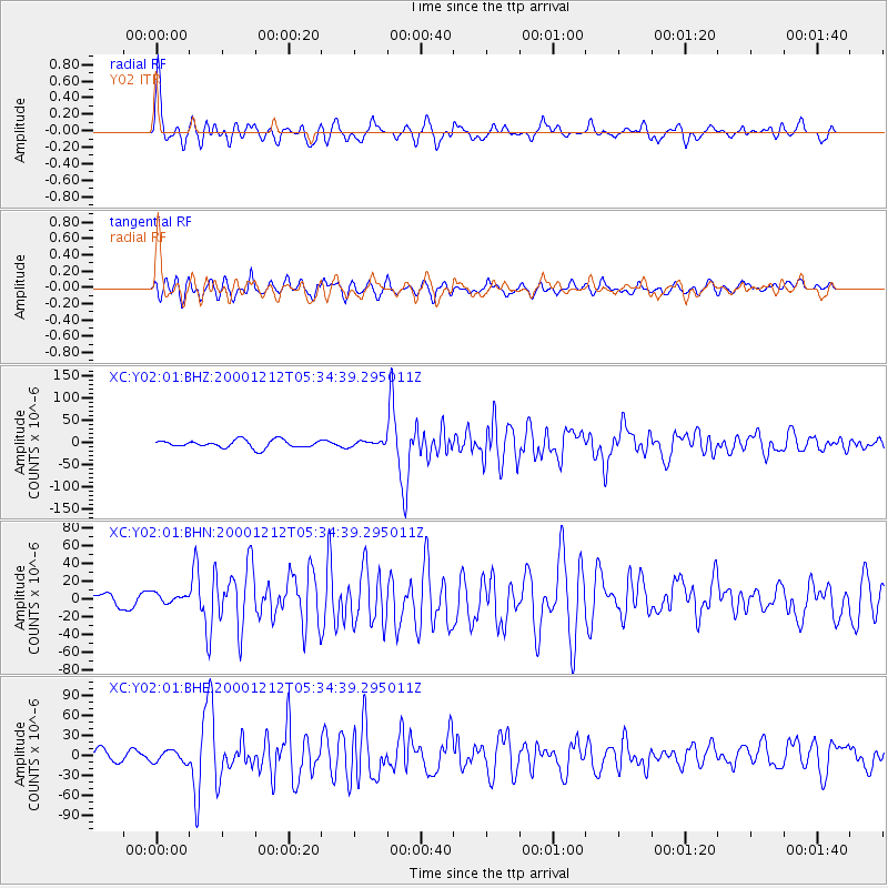
Earthquake location: South Of Panama
Earthquake latitude/longitude: 6.0/-82.7
Earthquake time(UTC): 2000/12/12 (347) 05:26:45 GMT
Earthquake Depth: 10 km
Earthquake Magnitude: 5.8 MB, 5.7 MS, 6.3 ME, 6.1 MW
Earthquake Catalog/Contributor: WHDF/NEIC
Network: XC Yellowstone Intermountain Seismic Array
Station: Y02 Y02
Lat/Lon: 44.07 N/112.64 W
Elevation: 1532 m
Distance: 46.1 deg
Az: 330.038 deg
Baz: 136.439 deg
Ray Param: 0.07084587
Estimated Moho Depth: 54.25 km
Estimated Crust Vp/Vs: 1.64
Assumed Crust Vp: 6.577 km/s
Estimated Crust Vs: 4.016 km/s
Estimated Crust Poisson's Ratio: 0.20
Radial Match: 83.87454 %
Radial Bump: 400
Transverse Match: 70.2697 %
Transverse Bump: 400
SOD ConfigId: 16820
Insert Time: 2010-02-26 15:03:21.613 +0000
GWidth: 2.5
Max Bumps: 400
Tol: 0.001

Signal To Noise

ChannelStoNSTALTA
XC:Y02:01:BHN:20001212T05:34:39.295011Z0.55953366.3972775E-61.14332315E-5
XC:Y02:01:BHE:20001212T05:34:39.295011Z1.19164288.604816E-67.2209696E-6
XC:Y02:01:BHZ:20001212T05:34:39.295011Z0.62900095.4092798E-68.599796E-6
Arrivals
Ps5.7 SECOND
PpPs20 SECOND
PsPs/PpSs26 SECOND