
Station XC Y02 - Y02
Network: XC00 - Yellowstone Intermountain Seismic Array
Nearby stations (2 deg radius)
| Station | Name | (Lat, Lon) | Start / End | Elevation |
| Y02 | Y02 | (44.07, -112.64) | 2000-06-27 / 2001-12-31 | 1532 m |
| Crust2 Type: | H3,early/mid Proter. shield, Finland, 0.5 km seds. |
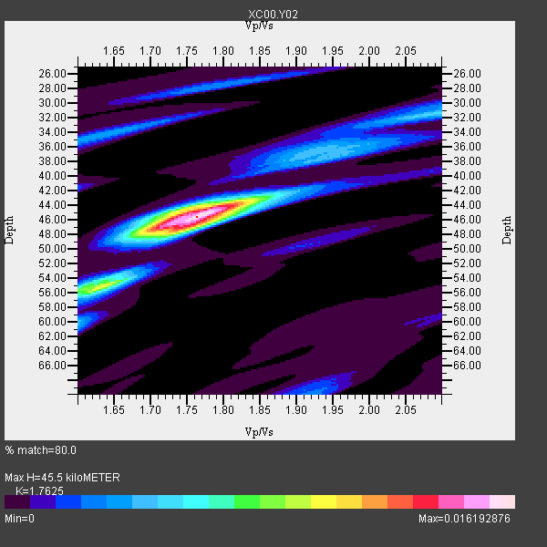
| Thickness Estimate: | 46 km |
| Thickness StdDev: | 6.1 km |
| Vp/Vs Estimate: | 1.76 |
| Vp/Vs StdDev: | 0.08 |
| Vs Estimate: | 3.732 km/s |
| Poisson's Ratio: | 0.26 |
| Peak Value: | 0.02 |
| Assumed Vp: | 6.577 km/s |
| Ps Weight: | 0.33333334 |
| PpPs Weight: | 0.33333334 |
| PsPs Weight: | 0.33333328 |
| Residual Complexity: | 0.467 |
| Nearby stations H: | +- |
| (2.0 deg) Vp/Vs: | +- |
3 with match > 90% ( 21.428572 %) and 14 with match > 80% ( 100.0 %) out of 14.
Download stack as xyz text file.
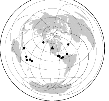
Azimuth Distribution of Events:
Prior Results for this Station
| Study | Thickness | Vp/Vs | Vp | Vs | Poissons Ratio | Extra |
| EARS | 46 km | 1.76 | 6.577 km/s | 3.732 km/s | 0.26 | |
| Crust2.0 | 46 km | 1.78 | 6.577 km/s | 3.701 km/s | 0.27 | H3,early/mid Proter. shield, Finland, 0.5 km seds. |
| Global Maxima | 46 km | 1.76 | 6.577 km/s | 3.732 km/s | 0.26 | amp=0.016192876 |
| Local Maxima 1 | 55 km | 1.63 | 6.577 km/s | 4.041 km/s | 0.20 | amp=0.007541992 |
| Local Maxima 2 | 44 km | 1.75 | 6.577 km/s | 3.748 km/s | 0.26 | amp=0.0068935677 |
| Local Maxima 3 | 47 km | 1.74 | 6.577 km/s | 3.78 km/s | 0.25 | amp=0.0052731857 |
| Local Maxima 4 | 34 km | 1.63 | 6.577 km/s | 4.035 km/s | 0.20 | amp=0.0039811702 |
| Predicted Arrivals for vertical incidence (zero ray parameter) | |
| Ps | 5.28 SECOND |
| PpPs | 19.11 SECOND |
| PsPs/PpSs | 24.39 SECOND |
Events Processed for this Station
Download zip of receiver functions as SAC
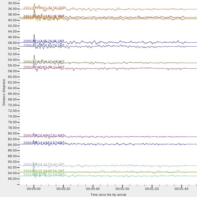
Plot maxima for each earthquake.
Events Used in the Stack
(14 events)| Radial Match | Distance | Baz | FERegion | Time | Lat/Lon | Depth | Magnitude |
| 95.32955 | 54.1 deg | 111.626 deg | Windward Islands | 2000/10/04 14:37:44 GMT | (11.1, -62.6) | 110 km | 5.6 MB, 5.4 MS, 6.1 MW, 5.9 MD |
| 94.74463 | 37.1 deg | 138.996 deg | El Salvador | 2001/01/13 17:33:32 GMT | (13.0, -88.7) | 60 km | 6.4 MB, 7.8 MS, 7.7 MW, 7.5 ME |
| 92.54338 | 82.7 deg | 237.707 deg | Tonga Islands | 2000/09/26 06:17:52 GMT | (-17.2, -173.9) | 56 km | 6.1 MB, 6.1 MS, 6.4 MW, 6.1 ME |
| 88.877655 | 96.4 deg | 245.611 deg | Southeast Of Loyalty Islands | 2001/02/28 13:05:31 GMT | (-22.0, 170.1) | 10 km | 5.8 MB, 6.1 MS, 6.2 MW |
| 88.51883 | 96.5 deg | 270.744 deg | New Ireland Region, P.N.G. | 2000/11/16 04:54:56 GMT | (-4.0, 152.2) | 33 km | 6.0 MB, 8.2 MS, 8.0 MW, 8.0 ME |
| 86.50867 | 36.5 deg | 138.889 deg | El Salvador | 2001/02/13 14:22:05 GMT | (13.7, -88.9) | 10 km | 5.5 MB, 6.5 MS, 6.6 MW, 6.1 MD |
| 85.887886 | 85.5 deg | 243.225 deg | Fiji Islands | 2000/09/14 14:59:57 GMT | (-15.7, 179.8) | 33 km | 5.7 MB, 6.2 MS, 6.3 MW, 6.2 MW |
| 84.44624 | 47.8 deg | 130.101 deg | Panama-Colombia Border Region | 2000/11/08 06:59:58 GMT | (7.0, -77.8) | 17 km | 6.0 MB, 6.4 MS, 6.5 MW, 6.2 ML |
| 83.87454 | 46.1 deg | 136.439 deg | South Of Panama | 2000/12/12 05:26:45 GMT | (6.0, -82.7) | 10 km | 5.8 MB, 5.7 MS, 6.3 ME, 6.1 MW |
| 82.783554 | 36.9 deg | 303.334 deg | Fox Islands, Aleutian Islands | 2000/12/05 22:11:34 GMT | (52.6, -167.8) | 33 km | 5.6 MB, 5.6 MS, 5.9 MW, 5.4 ML |
| 81.87104 | 93.9 deg | 252.42 deg | Vanuatu Islands | 2000/10/04 16:58:44 GMT | (-15.4, 166.9) | 23 km | 6.1 MB, 6.9 MS, 6.8 MW, 6.5 ME |
| 80.94207 | 56.2 deg | 76.675 deg | Northern Mid-Atlantic Ridge | 2000/10/05 13:39:11 GMT | (31.7, -41.0) | 10 km | 5.4 MB, 6.1 MS, 6.0 MW, 5.9 MW |
| 80.42699 | 97.8 deg | 269.916 deg | New Britain Region, P.N.G. | 2000/11/17 21:01:56 GMT | (-5.5, 151.8) | 33 km | 6.2 MB, 8.0 MS, 7.6 MW, 6.9 ME |
| 80.01507 | 33.2 deg | 143.142 deg | Mexico-Guatemala Border Region | 2001/01/19 01:12:52 GMT | (15.4, -92.7) | 93 km | 5.4 MB, 5.6 MD |
Losers
(0 events)| Radial Match | Distance | Baz | FERegion | Time | Lat/Lon | Depth | Magnitude | Reason |
