You are here: Home > Network List > XC00 - Yellowstone Intermountain Seismic Array Stations List
> Station Y02 Y02 > Earthquake Result Viewer
Y02 Y02 - Earthquake Result Viewer
| Earthquake location: |
Mexico-Guatemala Border Region |
| Earthquake latitude/longitude: |
15.4/-92.7 |
| Earthquake time(UTC): |
2001/01/19 (019) 01:12:52 GMT |
| Earthquake Depth: |
93 km |
| Earthquake Magnitude: |
5.4 MB, 5.6 MD |
| Earthquake Catalog/Contributor: |
WHDF/NEIC |
|
| Network: |
XC Yellowstone Intermountain Seismic Array |
| Station: |
Y02 Y02 |
| Lat/Lon: |
44.07 N/112.64 W |
| Elevation: |
1532 m |
|
| Distance: |
33.2 deg |
| Az: |
333.369 deg |
| Baz: |
143.142 deg |
| Ray Param: |
0.07805065 |
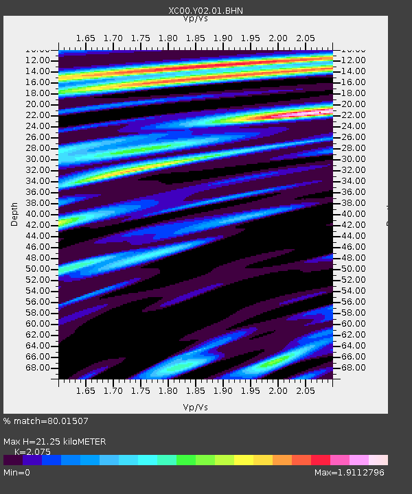
| Estimated Moho Depth: |
21.25 km |
| Estimated Crust Vp/Vs: |
2.08 |
| Assumed Crust Vp: |
6.577 km/s |
| Estimated Crust Vs: |
3.17 km/s |
| Estimated Crust Poisson's Ratio: |
0.35 |
|
| Radial Match: |
80.01507 % |
| Radial Bump: |
400 |
| Transverse Match: |
71.395515 % |
| Transverse Bump: |
400 |
| SOD ConfigId: |
16820 |
| Insert Time: |
2010-02-26 15:03:32.699 +0000 |
| GWidth: |
2.5 |
| Max Bumps: |
400 |
| Tol: |
0.001 |
|

Signal To Noise
| Channel | StoN | STA | LTA |
| XC:Y02:01:BHN:20010119T01:18:49.862013Z | 2.0353239 | 2.1100563E-5 | 1.0367177E-5 |
| XC:Y02:01:BHE:20010119T01:18:49.862013Z | 1.7055511 | 2.6923497E-5 | 1.5785805E-5 |
| XC:Y02:01:BHZ:20010119T01:18:49.862013Z | 1.5469736 | 2.6287378E-5 | 1.6992777E-5 |
| Arrivals |
| Ps | 3.7 SECOND |
| PpPs | 9.3 SECOND |
| PsPs/PpSs | 13 SECOND |


