You are here: Home > Network List > XC00 - Yellowstone Intermountain Seismic Array Stations List
> Station Y02 Y02 > Earthquake Result Viewer
Y02 Y02 - Earthquake Result Viewer
| Earthquake location: |
Southeast Of Loyalty Islands |
| Earthquake latitude/longitude: |
-22.0/170.1 |
| Earthquake time(UTC): |
2001/02/28 (059) 13:05:31 GMT |
| Earthquake Depth: |
10 km |
| Earthquake Magnitude: |
5.8 MB, 6.1 MS, 6.2 MW |
| Earthquake Catalog/Contributor: |
WHDF/NEIC |
|
| Network: |
XC Yellowstone Intermountain Seismic Array |
| Station: |
Y02 Y02 |
| Lat/Lon: |
44.07 N/112.64 W |
| Elevation: |
1532 m |
|
| Distance: |
96.4 deg |
| Az: |
45.021 deg |
| Baz: |
245.611 deg |
| Ray Param: |
0.04053991 |
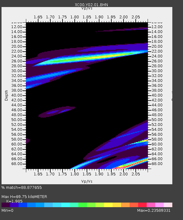
| Estimated Moho Depth: |
69.75 km |
| Estimated Crust Vp/Vs: |
1.99 |
| Assumed Crust Vp: |
6.577 km/s |
| Estimated Crust Vs: |
3.313 km/s |
| Estimated Crust Poisson's Ratio: |
0.33 |
|
| Radial Match: |
88.877655 % |
| Radial Bump: |
400 |
| Transverse Match: |
76.29855 % |
| Transverse Bump: |
400 |
| SOD ConfigId: |
3744 |
| Insert Time: |
2010-02-26 15:03:36.150 +0000 |
| GWidth: |
2.5 |
| Max Bumps: |
400 |
| Tol: |
0.001 |
|

Signal To Noise
| Channel | StoN | STA | LTA |
| XC:Y02:01:BHN:20010228T13:18:28.752Z | 1.5000808 | 6.0386046E-5 | 4.0255196E-5 |
| XC:Y02:01:BHE:20010228T13:18:28.752Z | 1.2709917 | 6.33614E-5 | 4.985194E-5 |
| XC:Y02:01:BHZ:20010228T13:18:28.752Z | 0.90140045 | 5.680058E-5 | 6.301371E-5 |
| Arrivals |
| Ps | 11 SECOND |
| PpPs | 31 SECOND |
| PsPs/PpSs | 42 SECOND |


