You are here: Home > Network List > AU - Australian Seismological Centre Stations List
> Station NRFK Norfolk Island, Australia > Earthquake Result Viewer
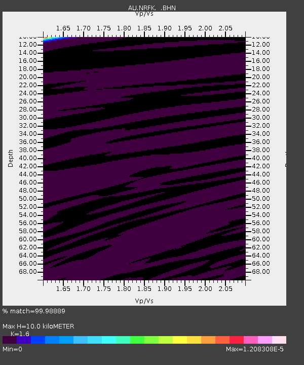
NRFK Norfolk Island, Australia - Earthquake Result Viewer
| Earthquake location: |
Kuril Islands |
| Earthquake latitude/longitude: |
43.1/146.5 |
| Earthquake time(UTC): |
2008/03/13 (073) 08:41:07 GMT |
| Earthquake Depth: |
53 km |
| Earthquake Magnitude: |
5.6 MB, 5.4 MW, 5.3 MW |
| Earthquake Catalog/Contributor: |
WHDF/NEIC |
|
| Network: |
AU Australian Seismological Centre |
| Station: |
NRFK Norfolk Island, Australia |
| Lat/Lon: |
29.04 S/167.96 E |
| Elevation: |
196 m |
|
| Distance: |
74.4 deg |
| Az: |
160.596 deg |
| Baz: |
343.856 deg |
| Ray Param: |
0.052249413 |
| Estimated Moho Depth: |
10.0 km |
| Estimated Crust Vp/Vs: |
1.60 |
| Assumed Crust Vp: |
4.662 km/s |
| Estimated Crust Vs: |
2.914 km/s |
| Estimated Crust Poisson's Ratio: |
0.18 |
|
| Radial Match: |
99.98889 % |
| Radial Bump: |
2 |
| Transverse Match: |
99.388535 % |
| Transverse Bump: |
27 |
| SOD ConfigId: |
2564 |
| Insert Time: |
2010-03-09 00:22:06.690 +0000 |
| GWidth: |
2.5 |
| Max Bumps: |
400 |
| Tol: |
0.001 |
|

Signal To Noise
| Channel | StoN | STA | LTA |
| AU:NRFK: :BHN:20080313T08:52:08.820002Z | 0.8326612 | 1.1743293E-6 | 1.4103327E-6 |
| AU:NRFK: :BHE:20080313T08:52:08.820002Z | 1.2345917 | 2.0940838E-6 | 1.6961752E-6 |
| AU:NRFK: :BHZ:20080313T08:52:08.820002Z | 0.9116986 | 1.2884213E-6 | 1.4132098E-6 |
| Arrivals |
| Ps | 1.3 SECOND |
| PpPs | 5.5 SECOND |
| PsPs/PpSs | 6.8 SECOND |


