
Station AU NRFK - Norfolk Island, Australia
Network: AU - Australian Seismological Centre
Nearby stations (2 deg radius)
| Station | Name | (Lat, Lon) | Start / End | Elevation |
| NRFK | Norfolk Island, Australia | (-29.04, 167.96) | 2006-09-26 / 2499-01-01 | 0.2 km |
| Crust2 Type: | B2,melt affected o.c. and oceanic plateaus, 1 km seds. |
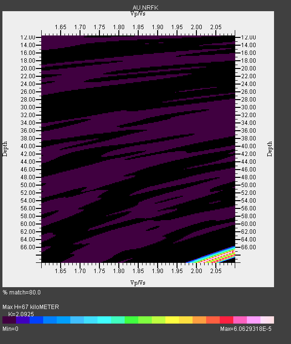
| Thickness Estimate: | 67 km |
| Thickness StdDev: | 17 km |
| Vp/Vs Estimate: | 2.09 |
| Vp/Vs StdDev: | 0.15 |
| Vs Estimate: | 2.228 km/s |
| Poisson's Ratio: | 0.35 |
| Peak Value: | 0.00 |
| Assumed Vp: | 4.662 km/s |
| Ps Weight: | 0.33333334 |
| PpPs Weight: | 0.33333334 |
| PsPs Weight: | 0.33333328 |
| Residual Complexity: | 0.561 |
| Nearby stations H: | +- |
| (2.0 deg) Vp/Vs: | +- |
12 with match > 90% ( 60.0 %) and 12 with match > 80% ( 60.0 %) out of 20.
Download stack as xyz text file.
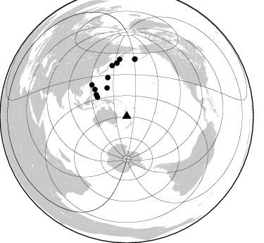
Azimuth Distribution of Events:
Prior Results for this Station
| Study | Thickness | Vp/Vs | Vp | Vs | Poissons Ratio | Extra |
| EARS | 67 km | 2.09 | 4.662 km/s | 2.228 km/s | 0.35 | |
| Crust2.0 | 16 km | 2.05 | 4.662 km/s | 2.269 km/s | 0.34 | B2,melt affected o.c. and oceanic plateaus, 1 km seds. |
| Global Maxima | 67 km | 2.09 | 4.662 km/s | 2.228 km/s | 0.35 | amp=6.0629318E-5 |
| Local Maxima 1 | 70 km | 2.01 | 4.662 km/s | 2.317 km/s | 0.34 | amp=5.5477987E-5 |
| Local Maxima 2 | 70 km | 2.04 | 4.662 km/s | 2.283 km/s | 0.34 | amp=3.1221083E-5 |
| Local Maxima 3 | 68 km | 2.10 | 4.662 km/s | 2.226 km/s | 0.35 | amp=1.447022E-5 |
| Local Maxima 4 | 68 km | 2.10 | 4.662 km/s | 2.223 km/s | 0.35 | amp=1.3220533E-6 |
| Predicted Arrivals for vertical incidence (zero ray parameter) | |
| Ps | 15.70 SECOND |
| PpPs | 44.44 SECOND |
| PsPs/PpSs | 60.14 SECOND |
Events Processed for this Station
Download zip of receiver functions as SAC
Plot maxima for each earthquake.
Events Used in the Stack
(12 events)| Radial Match | Distance | Baz | FERegion | Time | Lat/Lon | Depth | Magnitude |
| 99.99993 | 80.8 deg | 352.804 deg | Kamchatka Peninsula, Russia | 2008/03/06 09:38:43 GMT | (51.5, 156.5) | 134 km | 5.6 MB, 5.5 MW, 5.5 MW |
| 99.99988 | 81.7 deg | 8.244 deg | Andreanof Islands, Aleutian Is. | 2008/03/22 21:24:11 GMT | (52.2, -178.7) | 132 km | 5.8 MB, 6.2 MW, 6.1 MW |
| 99.99938 | 76.3 deg | 349.394 deg | Kuril Islands | 2008/03/26 18:33:34 GMT | (46.4, 153.0) | 17 km | 5.5 MB, 5.2 MS, 5.6 MW, 5.5 MW |
| 99.99892 | 81.3 deg | 7.942 deg | Andreanof Islands, Aleutian Is. | 2008/03/02 05:11:44 GMT | (51.9, -179.3) | 21 km | 5.6 MS, 5.4 MB, 5.8 MW, 5.7 MW |
| 99.99813 | 49.4 deg | 302.708 deg | Halmahera, Indonesia | 2008/03/06 01:21:59 GMT | (2.6, 128.2) | 125 km | 5.9 MB, 5.8 MW, 5.8 MW |
| 99.99747 | 52.8 deg | 304.927 deg | Mindanao, Philippines | 2008/03/20 14:10:44 GMT | (6.2, 126.9) | 82 km | 6.0 MB, 6.1 MW, 6.1 MW |
| 99.9918 | 48.6 deg | 324.938 deg | South Of Mariana Islands | 2008/02/28 09:12:54 GMT | (12.7, 141.8) | 10 km | 5.6 MB, 5.2 MS, 5.6 MW, 5.6 MW |
| 99.98959 | 76.3 deg | 349.525 deg | Kuril Islands | 2008/03/03 09:31:02 GMT | (46.4, 153.2) | 10 km | 6.2 MB, 6.5 MS, 6.5 MW, 6.5 MW |
| 99.98889 | 74.4 deg | 343.856 deg | Kuril Islands | 2008/03/13 08:41:07 GMT | (43.1, 146.5) | 53 km | 5.6 MB, 5.4 MW, 5.3 MW |
| 99.94126 | 60.7 deg | 333.794 deg | Bonin Islands, Japan Region | 2008/02/27 06:54:20 GMT | (26.8, 142.4) | 15 km | 5.8 MB, 6.1 MS, 6.2 MW, 6.2 MW |
| 99.90034 | 66.3 deg | 311.659 deg | Philippine Islands Region | 2008/03/03 13:49:40 GMT | (19.9, 121.3) | 10 km | 6.0 MB, 6.0 MW, 5.9 MW |
| 99.57447 | 58.7 deg | 309.918 deg | Philippine Islands Region | 2008/03/03 14:11:14 GMT | (13.4, 125.6) | 24 km | 6.4 MB, 6.9 MW, 6.8 MW |
Losers
(8 events)| Radial Match | Distance | Baz | FERegion | Time | Lat/Lon | Depth | Magnitude | Reason |
| 84.393074 | 93.0 deg | 42.315 deg | Off Coast Of Oregon | 2008/03/15 14:44:36 GMT | (42.4, -126.8) | 10 km | 5.5 MS, 5.3 MB, 5.7 MW, 5.7 MW | |
| 66.49475 | 45.0 deg | 289.485 deg | Banda Sea | 2008/04/19 03:12:25 GMT | (-7.8, 125.7) | 13 km | 5.8 MB, 5.8 MS, 6.1 MW, 6.1 MW | |
| 64.256775 | 67.3 deg | 277.733 deg | Southern Sumatra, Indonesia | 2008/03/03 17:48:32 GMT | (-4.5, 101.5) | 28 km | 5.6 MB, 5.0 MS | |
| 55.21305 | 44.9 deg | 289.436 deg | Banda Sea | 2008/04/19 10:21:12 GMT | (-7.9, 125.7) | 10 km | 5.6 MB, 5.6 MS, 6.0 MW, 6.0 MW | |
| 54.382244 | 93.2 deg | 221.672 deg | Southwest Indian Ridge | 2008/04/01 11:05:23 GMT | (-38.9, 46.3) | 10 km | 5.5 MB, 5.4 MW | |
| 52.080505 | 58.6 deg | 309.905 deg | Philippine Islands Region | 2008/03/29 03:01:31 GMT | (13.3, 125.7) | 18 km | 5.7 MB, 5.2 MS, 5.7 MW, 5.7 MW | |
| 33.71362 | 66.1 deg | 312.41 deg | Philippine Islands Region | 2008/03/29 08:09:47 GMT | (20.3, 122.0) | 16 km | 5.5 MB, 5.3 MS, 5.5 MW | |
| 33.042725 | 66.1 deg | 312.369 deg | Philippine Islands Region | 2008/03/28 22:41:32 GMT | (20.3, 121.9) | 10 km | 5.6 MB, 5.6 MS, 5.8 MW, 5.8 MW |
