You are here: Home > Network List > SP - South Carolina Earth Physics Project Stations List
> Station CLINT Clinton High School, Laurens County, SC USA > Earthquake Result Viewer
CLINT Clinton High School, Laurens County, SC USA - Earthquake Result Viewer

| Earthquake location: |
Chile-Bolivia Border Region |
| Earthquake latitude/longitude: |
-21.7/-68.3 |
| Earthquake time(UTC): |
2002/03/28 (087) 04:56:22 GMT |
| Earthquake Depth: |
125 km |
| Earthquake Magnitude: |
6.1 MB, 6.5 MW, 6.5 MW |
| Earthquake Catalog/Contributor: |
WHDF/NEIC |
|
| Network: |
SP South Carolina Earth Physics Project |
| Station: |
CLINT Clinton High School, Laurens County, SC USA |
| Lat/Lon: |
34.48 N/81.86 W |
| Elevation: |
199 m |
|
| Distance: |
57.3 deg |
| Az: |
346.719 deg |
| Baz: |
165.007 deg |
| Ray Param: |
0.06320295 |
| Estimated Moho Depth: |
28.5 km |
| Estimated Crust Vp/Vs: |
2.00 |
| Assumed Crust Vp: |
6.419 km/s |
| Estimated Crust Vs: |
3.214 km/s |
| Estimated Crust Poisson's Ratio: |
0.33 |
|
| Radial Match: |
92.31707 % |
| Radial Bump: |
400 |
| Transverse Match: |
74.73535 % |
| Transverse Bump: |
400 |
| SOD ConfigId: |
2255 |
| Insert Time: |
2010-02-25 16:36:11.178 +0000 |
| GWidth: |
2.5 |
| Max Bumps: |
400 |
| Tol: |
0.001 |
|
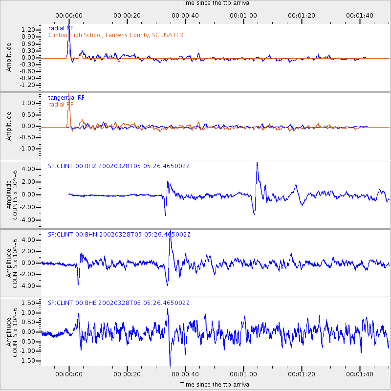
Signal To Noise
| Channel | StoN | STA | LTA |
| SP:CLINT:00:BHN:20020328T05:05:26.465002Z | 5.487549 | 1.2066354E-6 | 2.1988605E-7 |
| SP:CLINT:00:BHE:20020328T05:05:26.465002Z | 3.4892893 | 3.898154E-7 | 1.1171771E-7 |
| SP:CLINT:00:BHZ:20020328T05:05:26.465002Z | 12.623998 | 1.0779552E-6 | 8.538937E-8 |
| Arrivals |
| Ps | 4.6 SECOND |
| PpPs | 13 SECOND |
| PsPs/PpSs | 17 SECOND |


