
Station SP CLINT - Clinton High School, Laurens County, SC USA
Network: SP - South Carolina Earth Physics Project
Nearby stations (2 deg radius)
| Station | Name | (Lat, Lon) | Start / End | Elevation |
| CLINT | Clinton High School, Laurens County, SC USA | (34.48, -81.86) | 2001-11-13 / 2499-01-01 | 199 m |
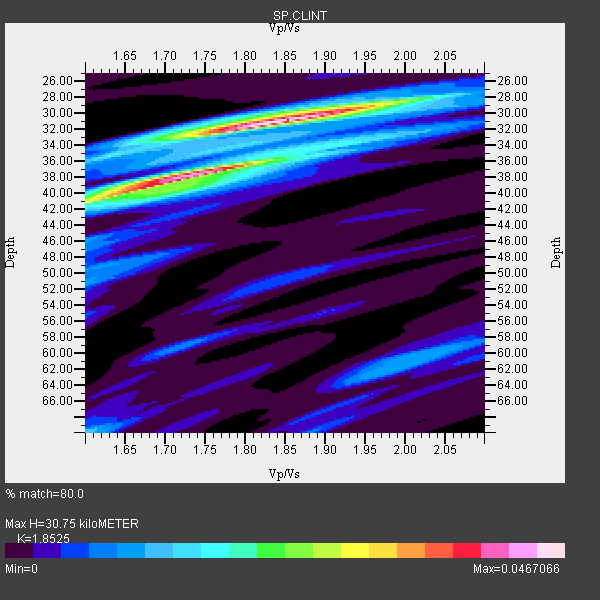
| Crust2 Type: | Q2,orogen/39km no ice, Appalachians, North Andes, 0.5 km seds. |
| Thickness Estimate: | 31 km |
| Thickness StdDev: | 5.8 km |
| Vp/Vs Estimate: | 1.85 |
| Vp/Vs StdDev: | 0.10 |
| Vs Estimate: | 3.465 km/s |
| Poisson's Ratio: | 0.29 |
| Peak Value: | 0.05 |
| Assumed Vp: | 6.419 km/s |
| Ps Weight: | 0.33333334 |
| PpPs Weight: | 0.33333334 |
| PsPs Weight: | 0.33333328 |
| Residual Complexity: | 0.677 |
| Nearby stations H: | +- |
| (2.0 deg) Vp/Vs: | +- |
4 with match > 90% ( 80.0 %) and 5 with match > 80% ( 100.0 %) out of 5.
Download stack as xyz text file.
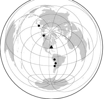
Azimuth Distribution of Events:
Prior Results for this Station
| Study | Thickness | Vp/Vs | Vp | Vs | Poissons Ratio | Extra |
| EARS | 31 km | 1.85 | 6.419 km/s | 3.465 km/s | 0.29 | |
| Crust2.0 | 39 km | 1.75 | 6.419 km/s | 3.659 km/s | 0.26 | Q2,orogen/39km no ice, Appalachians, North Andes, 0.5 km seds. |
| Global Maxima | 31 km | 1.85 | 6.419 km/s | 3.465 km/s | 0.29 | amp=0.0467066 |
| Local Maxima 1 | 37 km | 1.75 | 6.419 km/s | 3.658 km/s | 0.26 | amp=0.03554978 |
| Local Maxima 2 | 41 km | 1.60 | 6.419 km/s | 4.006 km/s | 0.18 | amp=0.021056794 |
| Local Maxima 3 | 70 km | 1.60 | 6.419 km/s | 4.012 km/s | 0.18 | amp=0.013968796 |
| Local Maxima 4 | 35 km | 1.63 | 6.419 km/s | 3.944 km/s | 0.20 | amp=0.013183896 |
| Predicted Arrivals for vertical incidence (zero ray parameter) | |
| Ps | 4.08 SECOND |
| PpPs | 13.66 SECOND |
| PsPs/PpSs | 17.75 SECOND |
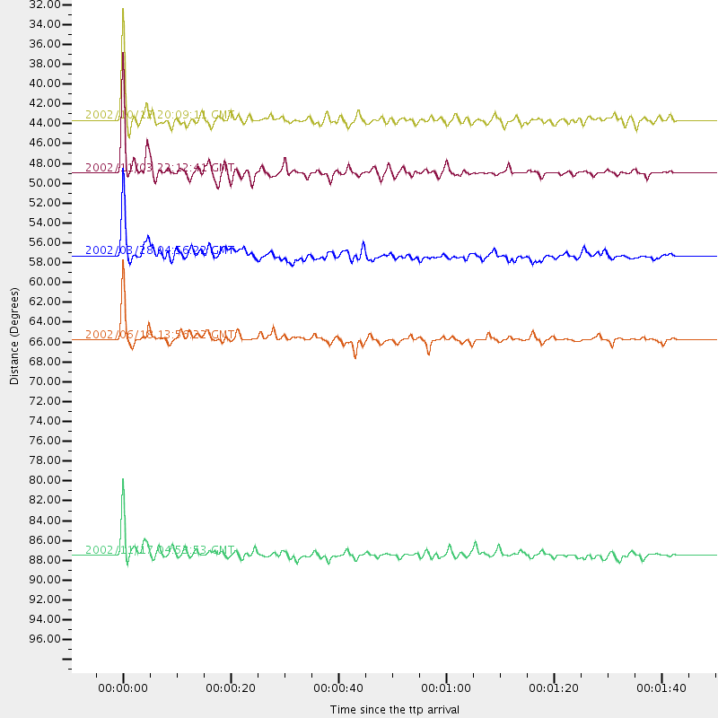
Events Processed for this Station
Download zip of receiver functions as SAC
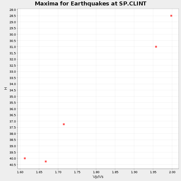
Plot maxima for each earthquake.
Events Used in the Stack
(5 events)| Radial Match | Distance | Baz | FERegion | Time | Lat/Lon | Depth | Magnitude |
| 98.33865 | 48.9 deg | 327.221 deg | Central Alaska | 2002/11/03 22:12:41 GMT | (63.5, -147.4) | 4.9 km | 7.0 MB, 8.5 MS, 7.9 MW |
| 96.67293 | 43.6 deg | 165.39 deg | Western Brazil | 2002/10/12 20:09:11 GMT | (-8.3, -71.7) | 534 km | 6.5 MB, 6.9 MW, 6.9 MW |
| 92.31707 | 57.3 deg | 165.007 deg | Chile-Bolivia Border Region | 2002/03/28 04:56:22 GMT | (-21.7, -68.3) | 125 km | 6.1 MB, 6.5 MW, 6.5 MW |
| 90.21688 | 65.7 deg | 169.87 deg | Near Coast Of Central Chile | 2002/06/18 13:56:22 GMT | (-30.8, -71.1) | 54 km | 6.0 MB, 6.6 MW, 6.4 MW |
| 89.91047 | 87.5 deg | 329.877 deg | Northwest Of Kuril Islands | 2002/11/17 04:53:53 GMT | (47.8, 146.2) | 459 km | 7.3 MW, 7.3 MW |
Losers
(0 events)| Radial Match | Distance | Baz | FERegion | Time | Lat/Lon | Depth | Magnitude | Reason |
