You are here: Home > Network List > SP - South Carolina Earth Physics Project Stations List
> Station CLINT Clinton High School, Laurens County, SC USA > Earthquake Result Viewer
CLINT Clinton High School, Laurens County, SC USA - Earthquake Result Viewer
| Earthquake location: |
Near Coast Of Central Chile |
| Earthquake latitude/longitude: |
-30.8/-71.1 |
| Earthquake time(UTC): |
2002/06/18 (169) 13:56:22 GMT |
| Earthquake Depth: |
54 km |
| Earthquake Magnitude: |
6.0 MB, 6.6 MW, 6.4 MW |
| Earthquake Catalog/Contributor: |
WHDF/NEIC |
|
| Network: |
SP South Carolina Earth Physics Project |
| Station: |
CLINT Clinton High School, Laurens County, SC USA |
| Lat/Lon: |
34.48 N/81.86 W |
| Elevation: |
199 m |
|
| Distance: |
65.7 deg |
| Az: |
350.279 deg |
| Baz: |
169.87 deg |
| Ray Param: |
0.057967335 |
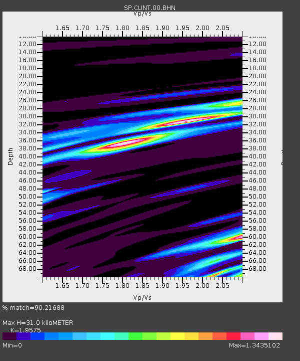
| Estimated Moho Depth: |
31.0 km |
| Estimated Crust Vp/Vs: |
1.96 |
| Assumed Crust Vp: |
6.419 km/s |
| Estimated Crust Vs: |
3.279 km/s |
| Estimated Crust Poisson's Ratio: |
0.32 |
|
| Radial Match: |
90.21688 % |
| Radial Bump: |
279 |
| Transverse Match: |
77.5611 % |
| Transverse Bump: |
400 |
| SOD ConfigId: |
2255 |
| Insert Time: |
2010-02-25 16:36:12.565 +0000 |
| GWidth: |
2.5 |
| Max Bumps: |
400 |
| Tol: |
0.001 |
|

Signal To Noise
| Channel | StoN | STA | LTA |
| SP:CLINT:00:BHN:20020618T14:06:31.134016Z | 2.9817653 | 1.0997906E-6 | 3.6883873E-7 |
| SP:CLINT:00:BHE:20020618T14:06:31.134016Z | 0.88462806 | 3.0837026E-7 | 3.4858746E-7 |
| SP:CLINT:00:BHZ:20020618T14:06:31.134016Z | 4.3129888 | 9.582643E-7 | 2.2218103E-7 |
| Arrivals |
| Ps | 4.8 SECOND |
| PpPs | 14 SECOND |
| PsPs/PpSs | 19 SECOND |


