You are here: Home > Network List > SP - South Carolina Earth Physics Project Stations List
> Station CLINT Clinton High School, Laurens County, SC USA > Earthquake Result Viewer
CLINT Clinton High School, Laurens County, SC USA - Earthquake Result Viewer
| Earthquake location: |
Western Brazil |
| Earthquake latitude/longitude: |
-8.3/-71.7 |
| Earthquake time(UTC): |
2002/10/12 (285) 20:09:11 GMT |
| Earthquake Depth: |
534 km |
| Earthquake Magnitude: |
6.5 MB, 6.9 MW, 6.9 MW |
| Earthquake Catalog/Contributor: |
WHDF/NEIC |
|
| Network: |
SP South Carolina Earth Physics Project |
| Station: |
CLINT Clinton High School, Laurens County, SC USA |
| Lat/Lon: |
34.48 N/81.86 W |
| Elevation: |
199 m |
|
| Distance: |
43.6 deg |
| Az: |
347.846 deg |
| Baz: |
165.39 deg |
| Ray Param: |
0.06983498 |
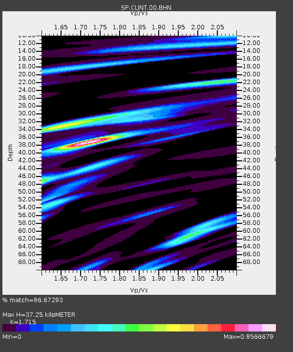
| Estimated Moho Depth: |
37.25 km |
| Estimated Crust Vp/Vs: |
1.72 |
| Assumed Crust Vp: |
6.419 km/s |
| Estimated Crust Vs: |
3.743 km/s |
| Estimated Crust Poisson's Ratio: |
0.24 |
|
| Radial Match: |
96.67293 % |
| Radial Bump: |
296 |
| Transverse Match: |
84.861534 % |
| Transverse Bump: |
400 |
| SOD ConfigId: |
2255 |
| Insert Time: |
2010-02-25 16:36:13.862 +0000 |
| GWidth: |
2.5 |
| Max Bumps: |
400 |
| Tol: |
0.001 |
|
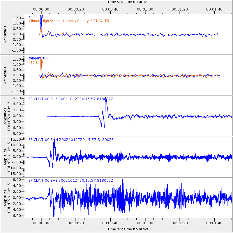
Signal To Noise
| Channel | StoN | STA | LTA |
| SP:CLINT:00:BHN:20021012T20:15:57.818002Z | 12.691348 | 1.9587221E-6 | 1.5433524E-7 |
| SP:CLINT:00:BHE:20021012T20:15:57.818002Z | 4.828917 | 8.2877045E-7 | 1.7162658E-7 |
| SP:CLINT:00:BHZ:20021012T20:15:57.818002Z | 12.388576 | 1.3920114E-6 | 1.1236251E-7 |
| Arrivals |
| Ps | 4.4 SECOND |
| PpPs | 15 SECOND |
| PsPs/PpSs | 19 SECOND |


