You are here: Home > Network List > SP - South Carolina Earth Physics Project Stations List
> Station CLINT Clinton High School, Laurens County, SC USA > Earthquake Result Viewer
CLINT Clinton High School, Laurens County, SC USA - Earthquake Result Viewer
| Earthquake location: |
Central Alaska |
| Earthquake latitude/longitude: |
63.5/-147.4 |
| Earthquake time(UTC): |
2002/11/03 (307) 22:12:41 GMT |
| Earthquake Depth: |
4.9 km |
| Earthquake Magnitude: |
7.0 MB, 8.5 MS, 7.9 MW |
| Earthquake Catalog/Contributor: |
WHDF/NEIC |
|
| Network: |
SP South Carolina Earth Physics Project |
| Station: |
CLINT Clinton High School, Laurens County, SC USA |
| Lat/Lon: |
34.48 N/81.86 W |
| Elevation: |
199 m |
|
| Distance: |
48.9 deg |
| Az: |
94.0 deg |
| Baz: |
327.221 deg |
| Ray Param: |
0.06903985 |
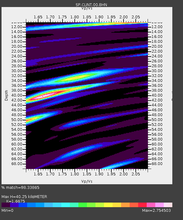
| Estimated Moho Depth: |
40.25 km |
| Estimated Crust Vp/Vs: |
1.67 |
| Assumed Crust Vp: |
6.419 km/s |
| Estimated Crust Vs: |
3.85 km/s |
| Estimated Crust Poisson's Ratio: |
0.22 |
|
| Radial Match: |
98.33865 % |
| Radial Bump: |
330 |
| Transverse Match: |
90.50235 % |
| Transverse Bump: |
400 |
| SOD ConfigId: |
2255 |
| Insert Time: |
2010-02-25 16:36:15.971 +0000 |
| GWidth: |
2.5 |
| Max Bumps: |
400 |
| Tol: |
0.001 |
|

Signal To Noise
| Channel | StoN | STA | LTA |
| SP:CLINT:00:BHN:20021103T22:20:57.101013Z | 5.3769403 | 8.1087217E-7 | 1.508055E-7 |
| SP:CLINT:00:BHE:20021103T22:20:57.101013Z | 3.5879748 | 6.77854E-7 | 1.8892385E-7 |
| SP:CLINT:00:BHZ:20021103T22:20:57.101013Z | 9.517491 | 7.845624E-7 | 8.243374E-8 |
| Arrivals |
| Ps | 4.5 SECOND |
| PpPs | 16 SECOND |
| PsPs/PpSs | 20 SECOND |


