You are here: Home > Network List > SP - South Carolina Earth Physics Project Stations List
> Station CLINT Clinton High School, Laurens County, SC USA > Earthquake Result Viewer
CLINT Clinton High School, Laurens County, SC USA - Earthquake Result Viewer
| Earthquake location: |
Northwest Of Kuril Islands |
| Earthquake latitude/longitude: |
47.8/146.2 |
| Earthquake time(UTC): |
2002/11/17 (321) 04:53:53 GMT |
| Earthquake Depth: |
459 km |
| Earthquake Magnitude: |
7.3 MW, 7.3 MW |
| Earthquake Catalog/Contributor: |
WHDF/NEIC |
|
| Network: |
SP South Carolina Earth Physics Project |
| Station: |
CLINT Clinton High School, Laurens County, SC USA |
| Lat/Lon: |
34.48 N/81.86 W |
| Elevation: |
199 m |
|
| Distance: |
87.5 deg |
| Az: |
37.966 deg |
| Baz: |
329.877 deg |
| Ray Param: |
0.04208061 |
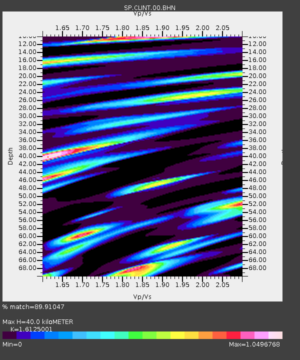
| Estimated Moho Depth: |
40.0 km |
| Estimated Crust Vp/Vs: |
1.61 |
| Assumed Crust Vp: |
6.419 km/s |
| Estimated Crust Vs: |
3.981 km/s |
| Estimated Crust Poisson's Ratio: |
0.19 |
|
| Radial Match: |
89.91047 % |
| Radial Bump: |
400 |
| Transverse Match: |
75.88778 % |
| Transverse Bump: |
400 |
| SOD ConfigId: |
2255 |
| Insert Time: |
2010-02-25 16:36:18.748 +0000 |
| GWidth: |
2.5 |
| Max Bumps: |
400 |
| Tol: |
0.001 |
|
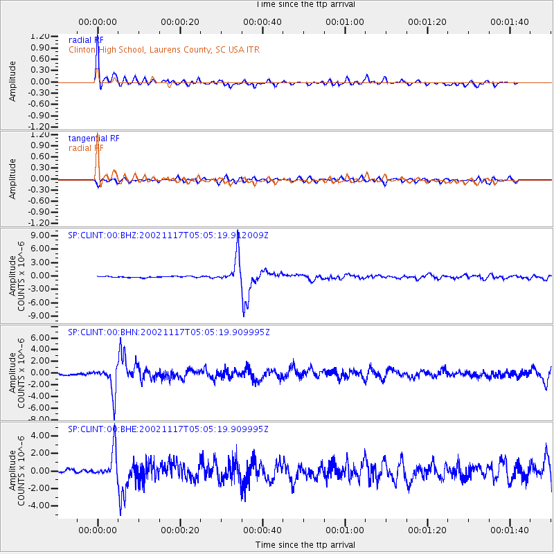
Signal To Noise
| Channel | StoN | STA | LTA |
| SP:CLINT:00:BHN:20021117T05:05:19.909995Z | 8.740142 | 2.3836583E-6 | 2.7272537E-7 |
| SP:CLINT:00:BHE:20021117T05:05:19.909995Z | 6.708942 | 1.7202408E-6 | 2.5641015E-7 |
| SP:CLINT:00:BHZ:20021117T05:05:19.912009Z | 24.978882 | 3.229267E-6 | 1.2927988E-7 |
| Arrivals |
| Ps | 3.9 SECOND |
| PpPs | 16 SECOND |
| PsPs/PpSs | 20 SECOND |


