You are here: Home > Network List > XC00 - Yellowstone Intermountain Seismic Array Stations List
> Station Y43 Y43 > Earthquake Result Viewer
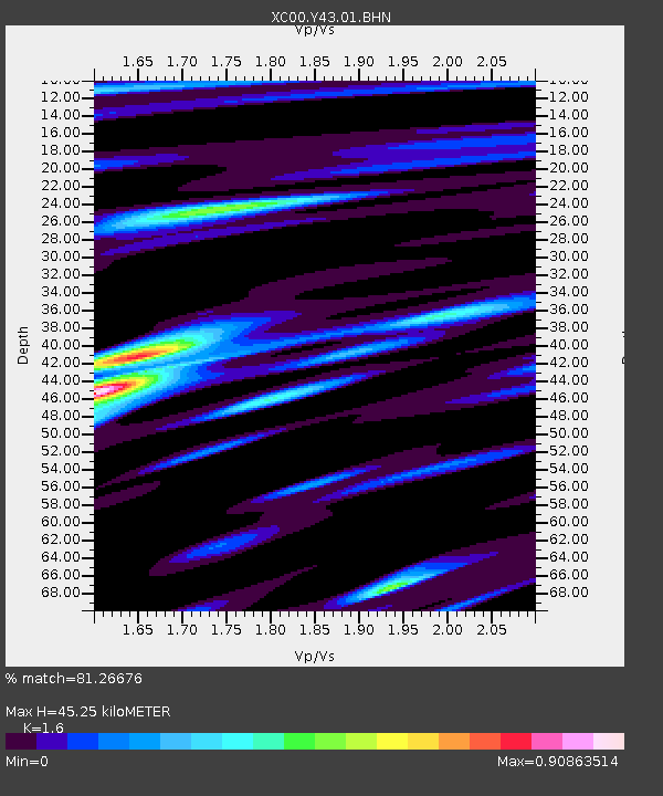
Y43 Y43 - Earthquake Result Viewer
| Earthquake location: |
Tonga Islands |
| Earthquake latitude/longitude: |
-15.9/-173.7 |
| Earthquake time(UTC): |
2000/09/11 (255) 17:17:53 GMT |
| Earthquake Depth: |
115 km |
| Earthquake Magnitude: |
6.0 MB, 6.3 MW, 6.3 MW |
| Earthquake Catalog/Contributor: |
WHDF/NEIC |
|
| Network: |
XC Yellowstone Intermountain Seismic Array |
| Station: |
Y43 Y43 |
| Lat/Lon: |
44.45 N/109.60 W |
| Elevation: |
1897 m |
|
| Distance: |
83.6 deg |
| Az: |
40.408 deg |
| Baz: |
240.58 deg |
| Ray Param: |
0.04581088 |
| Estimated Moho Depth: |
45.25 km |
| Estimated Crust Vp/Vs: |
1.60 |
| Assumed Crust Vp: |
6.242 km/s |
| Estimated Crust Vs: |
3.901 km/s |
| Estimated Crust Poisson's Ratio: |
0.18 |
|
| Radial Match: |
81.26676 % |
| Radial Bump: |
400 |
| Transverse Match: |
84.21479 % |
| Transverse Bump: |
400 |
| SOD ConfigId: |
16820 |
| Insert Time: |
2010-02-26 15:04:24.656 +0000 |
| GWidth: |
2.5 |
| Max Bumps: |
400 |
| Tol: |
0.001 |
|

Signal To Noise
| Channel | StoN | STA | LTA |
| XC:Y43:01:BHN:20000911T17:29:37.775Z | 2.2861266 | 4.791761E-7 | 2.0960172E-7 |
| XC:Y43:01:BHE:20000911T17:29:37.775Z | 2.6811643 | 2.78903E-7 | 1.04023094E-7 |
| XC:Y43:01:BHZ:20000911T17:29:37.775Z | 11.450382 | 2.1316162E-6 | 1.8616113E-7 |
| Arrivals |
| Ps | 4.5 SECOND |
| PpPs | 18 SECOND |
| PsPs/PpSs | 23 SECOND |


