
Station XC Y43 - Y43
Network: XC00 - Yellowstone Intermountain Seismic Array
Nearby stations (2 deg radius)
| Station | Name | (Lat, Lon) | Start / End | Elevation |
| Y43 | Y43 | (44.45, -109.60) | 2000-06-20 / 2001-12-31 | 1897 m |
| Crust2 Type: | PD,orogen/50km, Tibet, 2 km seds. |
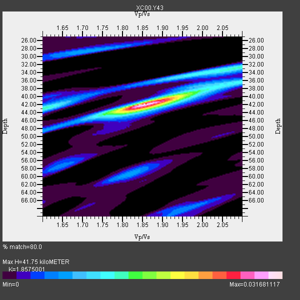
| Thickness Estimate: | 42 km |
| Thickness StdDev: | 2.8 km |
| Vp/Vs Estimate: | 1.86 |
| Vp/Vs StdDev: | 0.04 |
| Vs Estimate: | 3.36 km/s |
| Poisson's Ratio: | 0.30 |
| Peak Value: | 0.03 |
| Assumed Vp: | 6.242 km/s |
| Ps Weight: | 0.33333334 |
| PpPs Weight: | 0.33333334 |
| PsPs Weight: | 0.33333328 |
| Residual Complexity: | 0.530 |
| Nearby stations H: | +- |
| (2.0 deg) Vp/Vs: | +- |
3 with match > 90% ( 27.272728 %) and 11 with match > 80% ( 100.0 %) out of 11.
Download stack as xyz text file.
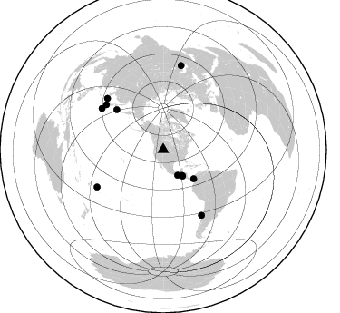
Azimuth Distribution of Events:
Prior Results for this Station
| Study | Thickness | Vp/Vs | Vp | Vs | Poissons Ratio | Extra |
| EARS | 42 km | 1.86 | 6.242 km/s | 3.36 km/s | 0.30 | |
| Crust2.0 | 50 km | 1.76 | 6.242 km/s | 3.546 km/s | 0.26 | PD,orogen/50km, Tibet, 2 km seds. |
| Global Maxima | 42 km | 1.86 | 6.242 km/s | 3.36 km/s | 0.30 | amp=0.031681117 |
| Local Maxima 1 | 43 km | 1.60 | 6.242 km/s | 3.901 km/s | 0.18 | amp=0.014126459 |
| Local Maxima 2 | 44 km | 1.82 | 6.242 km/s | 3.425 km/s | 0.28 | amp=0.010863343 |
| Local Maxima 3 | 38 km | 1.99 | 6.242 km/s | 3.137 km/s | 0.33 | amp=0.009516985 |
| Local Maxima 4 | 34 km | 1.96 | 6.242 km/s | 3.181 km/s | 0.32 | amp=0.007992108 |
| Predicted Arrivals for vertical incidence (zero ray parameter) | |
| Ps | 5.74 SECOND |
| PpPs | 19.11 SECOND |
| PsPs/PpSs | 24.85 SECOND |
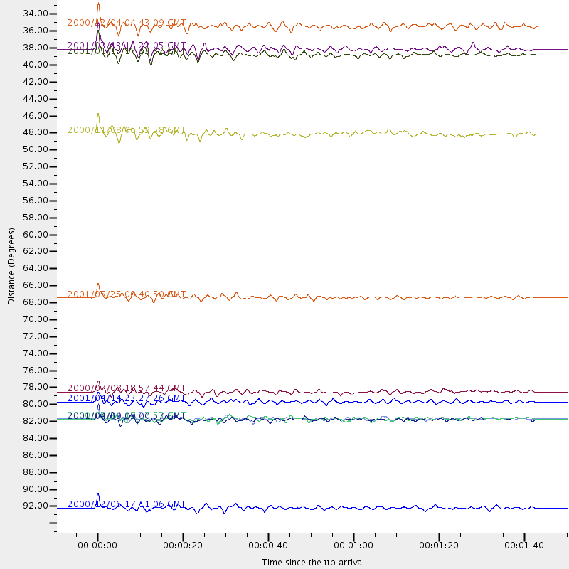
Events Processed for this Station
Download zip of receiver functions as SAC
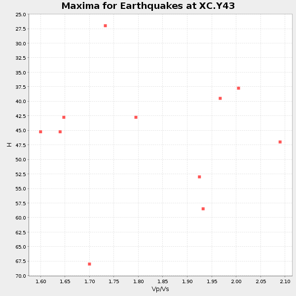
Plot maxima for each earthquake.
Events Used in the Stack
(11 events)| Radial Match | Distance | Baz | FERegion | Time | Lat/Lon | Depth | Magnitude |
| 93.11994 | 36.1 deg | 143.727 deg | El Salvador | 2001/01/13 17:33:32 GMT | (13.0, -88.7) | 60 km | 6.4 MB, 7.8 MS, 7.7 MW, 7.5 ME |
| 92.65788 | 67.8 deg | 310.61 deg | Kuril Islands | 2001/05/25 00:40:50 GMT | (44.3, 148.4) | 33 km | 6.1 MB, 6.7 MS, 6.7 MW, 6.6 MW |
| 91.98406 | 83.6 deg | 149.69 deg | Off Coast Of Central Chile | 2001/04/09 09:00:57 GMT | (-32.7, -73.1) | 11 km | 6.1 MB, 6.3 MS, 6.7 MW, 6.3 ME |
| 87.07147 | 83.6 deg | 312.417 deg | Western Honshu, Japan | 2001/03/24 06:27:53 GMT | (34.1, 132.5) | 50 km | 6.4 MB, 6.5 MS, 6.8 MW, 6.4 ME |
| 86.82153 | 81.4 deg | 303.837 deg | Southeast Of Honshu, Japan | 2001/04/14 23:27:26 GMT | (30.1, 141.8) | 10 km | 6.0 MB, 5.8 MS, 6.0 MW, 6.0 ME |
| 81.649345 | 35.4 deg | 143.683 deg | El Salvador | 2001/02/13 14:22:05 GMT | (13.7, -88.9) | 10 km | 5.5 MB, 6.5 MS, 6.6 MW, 6.1 MD |
| 81.26676 | 83.6 deg | 240.58 deg | Tonga Islands | 2000/09/11 17:17:53 GMT | (-15.9, -173.7) | 115 km | 6.0 MB, 6.3 MW, 6.3 MW |
| 80.970566 | 46.4 deg | 133.834 deg | Panama-Colombia Border Region | 2000/11/08 06:59:58 GMT | (7.0, -77.8) | 17 km | 6.0 MB, 6.4 MS, 6.5 MW, 6.2 ML |
| 80.89025 | 95.2 deg | 12.05 deg | Turkmenistan | 2000/12/06 17:11:06 GMT | (39.6, 54.8) | 30 km | 6.7 MB, 7.5 MS, 7.0 MW, 6.9 ME |
| 80.67587 | 32.3 deg | 150.814 deg | Near Coast Of Chiapas, Mexico | 2000/12/04 04:43:09 GMT | (14.9, -93.9) | 33 km | 5.6 MB, 5.7 MS, 6.0 MW, 5.9 MW |
| 80.14104 | 80.0 deg | 308.229 deg | Near S. Coast Of Honshu, Japan | 2000/07/08 18:57:44 GMT | (34.1, 139.1) | 10 km | 5.9 MB, 5.6 MS, 6.0 MW, 5.9 MW |
Losers
(0 events)| Radial Match | Distance | Baz | FERegion | Time | Lat/Lon | Depth | Magnitude | Reason |
