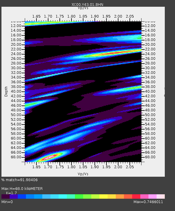
Y43 Y43 - Earthquake Result Viewer
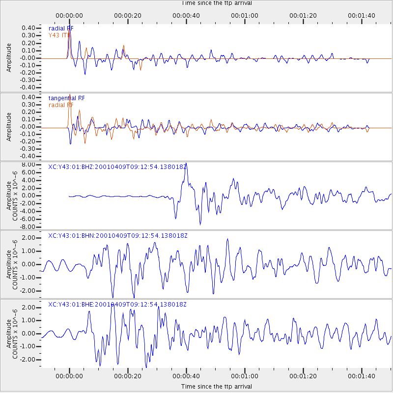
Earthquake location: Off Coast Of Central Chile
Earthquake latitude/longitude: -32.7/-73.1
Earthquake time(UTC): 2001/04/09 (099) 09:00:57 GMT
Earthquake Depth: 11 km
Earthquake Magnitude: 6.1 MB, 6.3 MS, 6.7 MW, 6.3 ME
Earthquake Catalog/Contributor: WHDF/NEIC
Network: XC Yellowstone Intermountain Seismic Array
Station: Y43 Y43
Lat/Lon: 44.45 N/109.60 W
Elevation: 1897 m
Distance: 83.6 deg
Az: 334.627 deg
Baz: 149.69 deg
Ray Param: 0.046040244
Estimated Moho Depth: 68.0 km
Estimated Crust Vp/Vs: 1.70
Assumed Crust Vp: 6.242 km/s
Estimated Crust Vs: 3.672 km/s
Estimated Crust Poisson's Ratio: 0.24
Radial Match: 91.98406 %
Radial Bump: 400
Transverse Match: 87.05377 %
Transverse Bump: 400
SOD ConfigId: 16820
Insert Time: 2010-02-26 15:04:25.785 +0000
GWidth: 2.5
Max Bumps: 400
Tol: 0.001

Signal To Noise

ChannelStoNSTALTA
XC:Y43:01:BHN:20010409T09:12:54.138018Z1.03421632.6651438E-72.5769694E-7
XC:Y43:01:BHE:20010409T09:12:54.138018Z1.76972332.8332894E-71.6009787E-7
XC:Y43:01:BHZ:20010409T09:12:54.138018Z2.38394833.0733773E-71.2891962E-7
Arrivals
Ps7.8 SECOND
PpPs29 SECOND
PsPs/PpSs37 SECOND