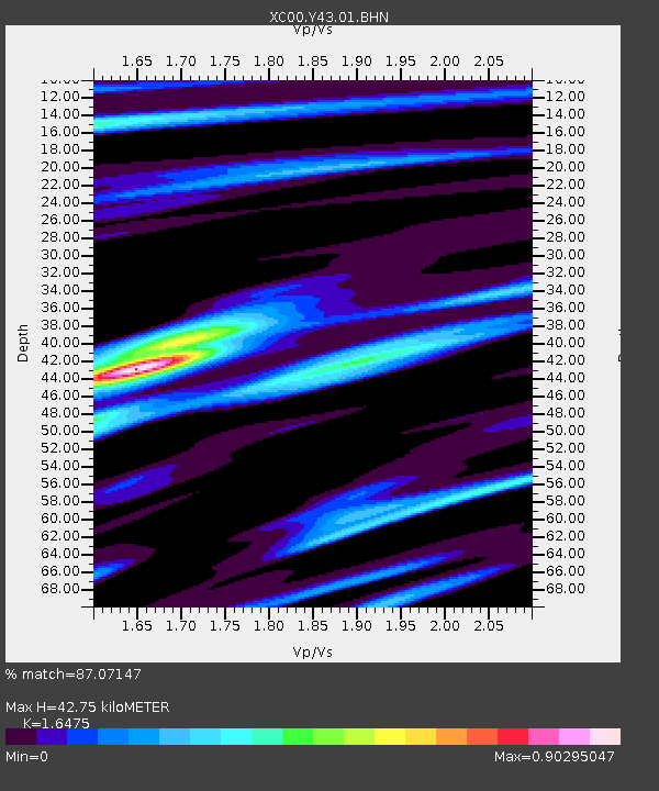
Y43 Y43 - Earthquake Result Viewer

Earthquake location: Western Honshu, Japan
Earthquake latitude/longitude: 34.1/132.5
Earthquake time(UTC): 2001/03/24 (083) 06:27:53 GMT
Earthquake Depth: 50 km
Earthquake Magnitude: 6.4 MB, 6.5 MS, 6.8 MW, 6.4 ME
Earthquake Catalog/Contributor: WHDF/NEIC
Network: XC Yellowstone Intermountain Seismic Array
Station: Y43 Y43
Lat/Lon: 44.45 N/109.60 W
Elevation: 1897 m
Distance: 83.6 deg
Az: 39.571 deg
Baz: 312.417 deg
Ray Param: 0.04598273
Estimated Moho Depth: 42.75 km
Estimated Crust Vp/Vs: 1.65
Assumed Crust Vp: 6.242 km/s
Estimated Crust Vs: 3.789 km/s
Estimated Crust Poisson's Ratio: 0.21
Radial Match: 87.07147 %
Radial Bump: 400
Transverse Match: 85.566086 %
Transverse Bump: 400
SOD ConfigId: 4714
Insert Time: 2010-02-26 15:04:26.711 +0000
GWidth: 2.5
Max Bumps: 400
Tol: 0.001

Signal To Noise

ChannelStoNSTALTA
XC:Y43:01:BHN:20010324T06:39:45.512007Z1.997774.3818616E-72.1933764E-7
XC:Y43:01:BHE:20010324T06:39:45.512007Z2.92558886.9993405E-72.3924554E-7
XC:Y43:01:BHZ:20010324T06:39:45.512007Z7.7194162.6765654E-63.4673158E-7
Arrivals
Ps4.6 SECOND
PpPs18 SECOND
PsPs/PpSs22 SECOND