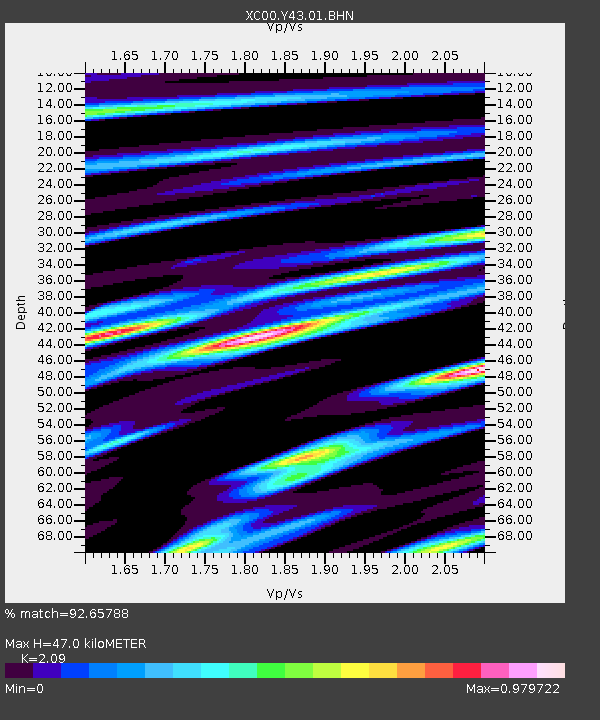
Y43 Y43 - Earthquake Result Viewer
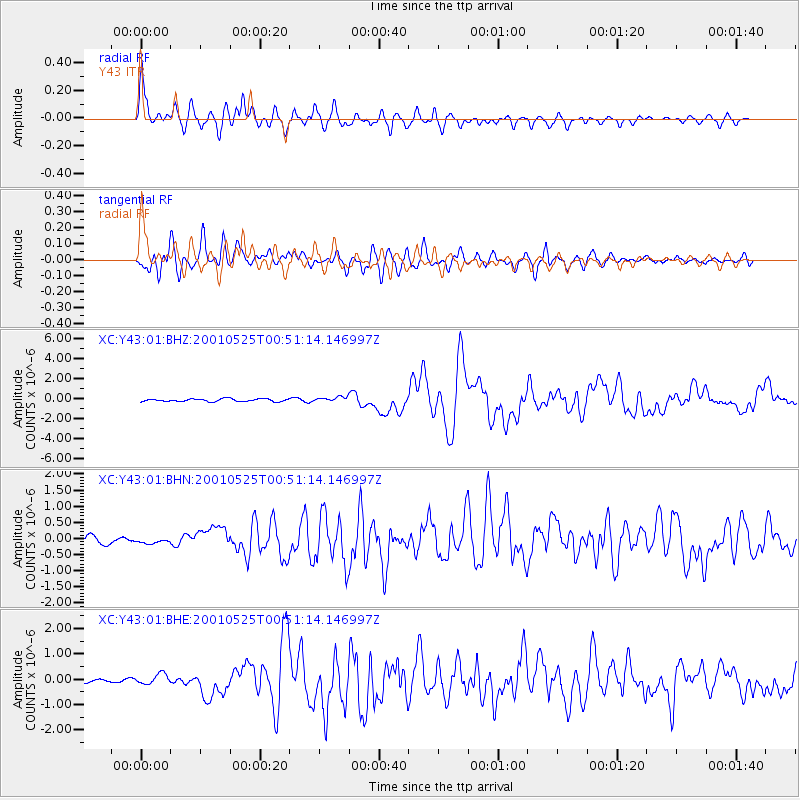
Earthquake location: Kuril Islands
Earthquake latitude/longitude: 44.3/148.4
Earthquake time(UTC): 2001/05/25 (145) 00:40:50 GMT
Earthquake Depth: 33 km
Earthquake Magnitude: 6.1 MB, 6.7 MS, 6.7 MW, 6.6 MW
Earthquake Catalog/Contributor: WHDF/NEIC
Network: XC Yellowstone Intermountain Seismic Array
Station: Y43 Y43
Lat/Lon: 44.45 N/109.60 W
Elevation: 1897 m
Distance: 67.8 deg
Az: 49.181 deg
Baz: 310.61 deg
Ray Param: 0.05669318
Estimated Moho Depth: 47.0 km
Estimated Crust Vp/Vs: 2.09
Assumed Crust Vp: 6.242 km/s
Estimated Crust Vs: 2.987 km/s
Estimated Crust Poisson's Ratio: 0.35
Radial Match: 92.65788 %
Radial Bump: 400
Transverse Match: 90.767525 %
Transverse Bump: 400
SOD ConfigId: 4714
Insert Time: 2010-02-26 15:04:30.604 +0000
GWidth: 2.5
Max Bumps: 400
Tol: 0.001

Signal To Noise

ChannelStoNSTALTA
XC:Y43:01:BHN:20010525T00:51:14.146997Z0.8102469.01545E-81.11268065E-7
XC:Y43:01:BHE:20010525T00:51:14.146997Z2.81010152.0107905E-77.155579E-8
XC:Y43:01:BHZ:20010525T00:51:14.146997Z1.80039622.4761763E-71.3753507E-7
Arrivals
Ps8.5 SECOND
PpPs23 SECOND
PsPs/PpSs31 SECOND