You are here: Home > Network List > YJ01 - Ethiopia-Afar Geoscientific Lithospheric Experiment Stations List
> Station ADEE Adele High School > Earthquake Result Viewer
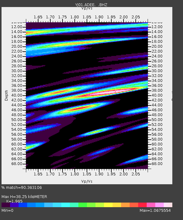
ADEE Adele High School - Earthquake Result Viewer
| Earthquake location: |
Eastern Honshu, Japan |
| Earthquake latitude/longitude: |
39.4/141.1 |
| Earthquake time(UTC): |
2001/12/02 (336) 13:01:53 GMT |
| Earthquake Depth: |
124 km |
| Earthquake Magnitude: |
6.1 MB, 6.5 MW, 6.5 MW |
| Earthquake Catalog/Contributor: |
WHDF/NEIC |
|
| Network: |
YJ Ethiopia-Afar Geoscientific Lithospheric Experiment |
| Station: |
ADEE Adele High School |
| Lat/Lon: |
7.79 N/39.91 E |
| Elevation: |
2485 m |
|
| Distance: |
93.7 deg |
| Az: |
283.079 deg |
| Baz: |
49.609 deg |
| Ray Param: |
0.041144688 |
| Estimated Moho Depth: |
38.25 km |
| Estimated Crust Vp/Vs: |
1.97 |
| Assumed Crust Vp: |
6.464 km/s |
| Estimated Crust Vs: |
3.289 km/s |
| Estimated Crust Poisson's Ratio: |
0.33 |
|
| Radial Match: |
90.363106 % |
| Radial Bump: |
400 |
| Transverse Match: |
77.98527 % |
| Transverse Bump: |
400 |
| SOD ConfigId: |
20082 |
| Insert Time: |
2010-03-09 00:39:17.979 +0000 |
| GWidth: |
2.5 |
| Max Bumps: |
400 |
| Tol: |
0.001 |
|

Signal To Noise
| Channel | StoN | STA | LTA |
| YJ:ADEE: :BHZ:20011202T13:14:24.779009Z | 1.18595 | 1.08786715E-7 | 9.1729596E-8 |
| YJ:ADEE: :BHN:20011202T13:14:24.779009Z | 1.5316827 | 1.5264317E-7 | 9.965717E-8 |
| YJ:ADEE: :BHE:20011202T13:14:24.779009Z | 1.7917278 | 1.6407151E-7 | 9.157167E-8 |
| Arrivals |
| Ps | 5.8 SECOND |
| PpPs | 17 SECOND |
| PsPs/PpSs | 23 SECOND |


