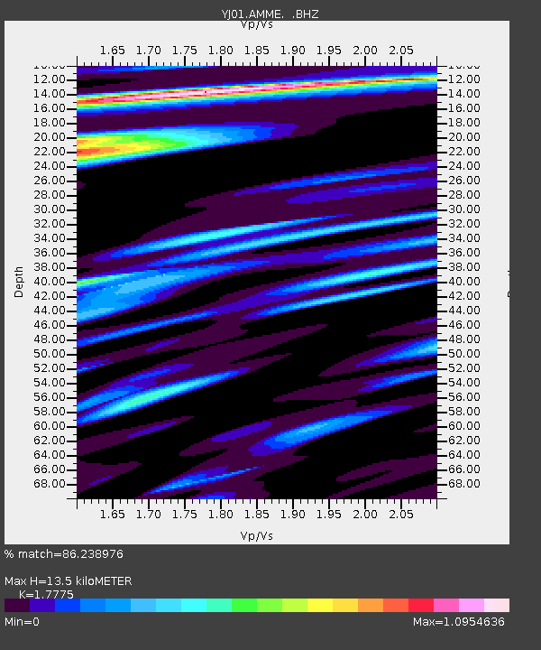
AMME Amudi Junior School - Earthquake Result Viewer

Earthquake location: South Georgia Island Region
Earthquake latitude/longitude: -56.1/-36.4
Earthquake time(UTC): 2002/11/15 (319) 19:58:31 GMT
Earthquake Depth: 10 km
Earthquake Magnitude: 6.1 MB, 6.6 MS, 6.7 MW, 6.4 MW
Earthquake Catalog/Contributor: WHDF/NEIC
Network: YJ Ethiopia-Afar Geoscientific Lithospheric Experiment
Station: AMME Amudi Junior School
Lat/Lon: 8.30 N/39.09 E
Elevation: 1670 m
Distance: 88.8 deg
Az: 73.399 deg
Baz: 212.907 deg
Ray Param: 0.042288356
Estimated Moho Depth: 13.5 km
Estimated Crust Vp/Vs: 1.78
Assumed Crust Vp: 6.464 km/s
Estimated Crust Vs: 3.636 km/s
Estimated Crust Poisson's Ratio: 0.27
Radial Match: 86.238976 %
Radial Bump: 400
Transverse Match: 82.64965 %
Transverse Bump: 400
SOD ConfigId: 16820
Insert Time: 2010-03-09 00:39:43.286 +0000
GWidth: 2.5
Max Bumps: 400
Tol: 0.001

Signal To Noise

ChannelStoNSTALTA
YJ:AMME: :BHZ:20021115T20:10:54.378022Z1.30332939.1685145E-87.034687E-8
YJ:AMME: :BHN:20021115T20:10:54.378022Z1.25694941.398914E-71.11294376E-7
YJ:AMME: :BHE:20021115T20:10:54.378022Z0.83974436.769076E-88.060877E-8
Arrivals
Ps1.7 SECOND
PpPs5.7 SECOND
PsPs/PpSs7.3 SECOND