
Station YJ AMME - Amudi Junior School
Network: YJ01 - Ethiopia-Afar Geoscientific Lithospheric Experiment
Nearby stations (2 deg radius)
| Station | Name | (Lat, Lon) | Start / End | Elevation |
| AMME | Amudi Junior School | (8.30, 39.09) | 2001-10-31 / 2003-02-01 | 1670 m |
| Crust2 Type: | G9,thin custal Archean 0.1 km seds., South American |
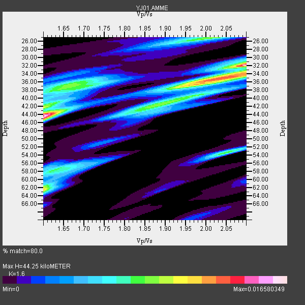
| Thickness Estimate: | 44 km |
| Thickness StdDev: | 9.6 km |
| Vp/Vs Estimate: | 1.60 |
| Vp/Vs StdDev: | 0.23 |
| Vs Estimate: | 4.04 km/s |
| Poisson's Ratio: | 0.18 |
| Peak Value: | 0.02 |
| Assumed Vp: | 6.464 km/s |
| Ps Weight: | 0.33333334 |
| PpPs Weight: | 0.33333334 |
| PsPs Weight: | 0.33333328 |
| Residual Complexity: | 0.886 |
| Nearby stations H: | +- |
| (2.0 deg) Vp/Vs: | +- |
0 with match > 90% ( 0.0 %) and 9 with match > 80% ( 100.0 %) out of 9.
Download stack as xyz text file.
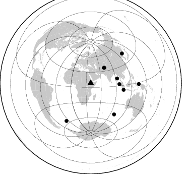
Azimuth Distribution of Events:
Prior Results for this Station
| Study | Thickness | Vp/Vs | Vp | Vs | Poissons Ratio | Extra |
| EARS | 44 km | 1.60 | 6.464 km/s | 4.04 km/s | 0.18 | |
| Crust2.0 | 31 km | 1.76 | 6.464 km/s | 3.663 km/s | 0.26 | G9,thin custal Archean 0.1 km seds., South American |
| Global Maxima | 44 km | 1.60 | 6.464 km/s | 4.04 km/s | 0.18 | amp=0.016580349 |
| Local Maxima 1 | 32 km | 2.09 | 6.464 km/s | 3.089 km/s | 0.35 | amp=0.015950413 |
| Local Maxima 2 | 62 km | 1.60 | 6.464 km/s | 4.04 km/s | 0.18 | amp=0.011213104 |
| Local Maxima 3 | 35 km | 2.04 | 6.464 km/s | 3.165 km/s | 0.34 | amp=0.008932336 |
| Local Maxima 4 | 25 km | 2.00 | 6.464 km/s | 3.24 km/s | 0.33 | amp=0.0073729656 |
| Predicted Arrivals for vertical incidence (zero ray parameter) | |
| Ps | 4.11 SECOND |
| PpPs | 17.80 SECOND |
| PsPs/PpSs | 21.91 SECOND |
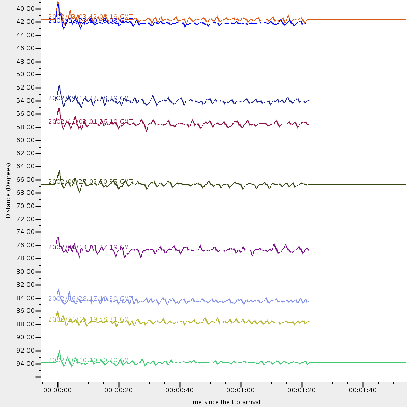
Events Processed for this Station
Download zip of receiver functions as SAC
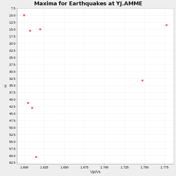
Plot maxima for each earthquake.
Events Used in the Stack
(9 events)| Radial Match | Distance | Baz | FERegion | Time | Lat/Lon | Depth | Magnitude |
| 88.71869 | 56.9 deg | 92.026 deg | Northern Sumatra, Indonesia | 2002/11/02 01:26:10 GMT | (2.8, 96.1) | 30 km | 6.2 MB, 7.6 MS, 7.4 MW, 7.4 MW |
| 88.6078 | 95.4 deg | 90.986 deg | Irian Jaya Region, Indonesia | 2002/10/10 10:50:20 GMT | (-1.8, 134.3) | 10 km | 6.5 MB, 7.7 MS, 7.6 MW, 7.4 MW |
| 87.896904 | 40.6 deg | 41.614 deg | Afghanistan-Tajikistan Bord Reg. | 2001/11/23 20:43:03 GMT | (36.4, 71.5) | 106 km | 5.9 MB, 6.1 MW, 6.0 MW |
| 86.238976 | 88.8 deg | 212.907 deg | South Georgia Island Region | 2002/11/15 19:58:31 GMT | (-56.1, -36.4) | 10 km | 6.1 MB, 6.6 MS, 6.7 MW, 6.4 MW |
| 84.99241 | 66.6 deg | 101.255 deg | Sunda Strait, Indonesia | 2002/06/27 05:50:35 GMT | (-7.0, 104.2) | 11 km | 6.0 MB, 6.9 MS, 6.6 MW, 6.5 MW |
| 84.39049 | 40.0 deg | 40.725 deg | Hindu Kush Region, Afghanistan | 2002/03/03 12:08:19 GMT | (36.5, 70.5) | 226 km | 6.6 MB, 7.4 MW, 7.3 MW |
| 82.36737 | 77.2 deg | 142.945 deg | Southeast Indian Ridge | 2002/06/13 01:27:19 GMT | (-47.8, 99.8) | 10 km | 5.5 MB, 6.6 MS, 6.6 MW, 6.5 MW |
| 82.31746 | 85.5 deg | 46.607 deg | E. Russia-N.E. China Border Reg. | 2002/06/28 17:19:30 GMT | (43.8, 130.7) | 566 km | 6.7 MB, 7.3 MW, 7.3 MW |
| 80.909424 | 53.2 deg | 79.958 deg | Andaman Islands, India Region | 2002/09/13 22:28:29 GMT | (13.0, 93.1) | 21 km | 6.2 MB, 6.7 MS, 6.5 MW, 6.5 MW |
Losers
(0 events)| Radial Match | Distance | Baz | FERegion | Time | Lat/Lon | Depth | Magnitude | Reason |
