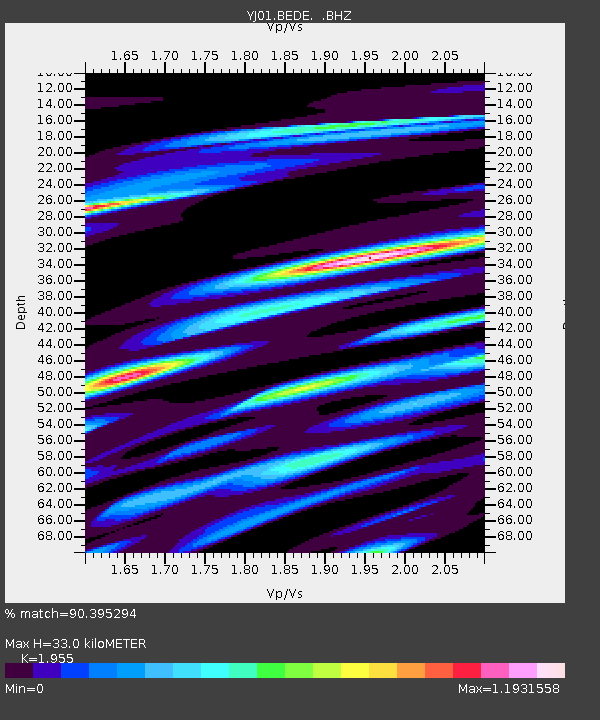
BEDE Bedesa High School - Earthquake Result Viewer

Earthquake location: Northwestern Kashmir
Earthquake latitude/longitude: 35.4/74.5
Earthquake time(UTC): 2002/11/20 (324) 21:32:30 GMT
Earthquake Depth: 33 km
Earthquake Magnitude: 5.7 MB, 6.5 MS, 6.4 MW, 6.0 MW
Earthquake Catalog/Contributor: WHDF/NEIC
Network: YJ Ethiopia-Afar Geoscientific Lithospheric Experiment
Station: BEDE Bedesa High School
Lat/Lon: 8.91 N/40.77 E
Elevation: 1714 m
Distance: 40.5 deg
Az: 237.6 deg
Baz: 44.264 deg
Ray Param: 0.07427435
Estimated Moho Depth: 33.0 km
Estimated Crust Vp/Vs: 1.96
Assumed Crust Vp: 6.643 km/s
Estimated Crust Vs: 3.398 km/s
Estimated Crust Poisson's Ratio: 0.32
Radial Match: 90.395294 %
Radial Bump: 357
Transverse Match: 72.087654 %
Transverse Bump: 400
SOD ConfigId: 16820
Insert Time: 2010-03-09 00:40:35.884 +0000
GWidth: 2.5
Max Bumps: 400
Tol: 0.001

Signal To Noise

ChannelStoNSTALTA
YJ:BEDE: :BHZ:20021120T21:39:36.480013Z1.47593411.3586609E-79.205431E-8
YJ:BEDE: :BHN:20021120T21:39:36.480013Z1.03352241.0354914E-71.0019052E-7
YJ:BEDE: :BHE:20021120T21:39:36.480013Z0.9707331.04819485E-71.0797973E-7
Arrivals
Ps5.1 SECOND
PpPs14 SECOND
PsPs/PpSs19 SECOND