
Station YJ BEDE - Bedesa High School
Network: YJ01 - Ethiopia-Afar Geoscientific Lithospheric Experiment
Nearby stations (2 deg radius)
| Station | Name | (Lat, Lon) | Start / End | Elevation |
| BEDE | Bedesa High School | (8.91, 40.77) | 2001-11-15 / 2003-01-24 | 1714 m |
| Crust2 Type: | IG,very thin late Proter., no seds. |
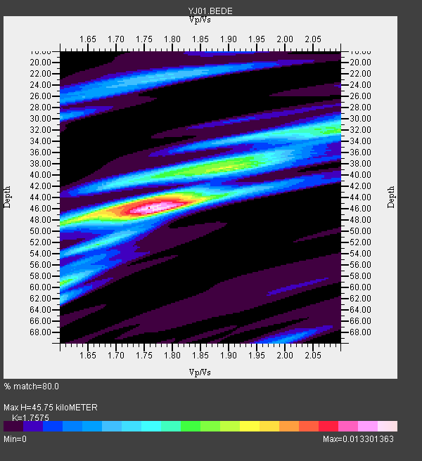
| Thickness Estimate: | 46 km |
| Thickness StdDev: | 4.5 km |
| Vp/Vs Estimate: | 1.76 |
| Vp/Vs StdDev: | 0.08 |
| Vs Estimate: | 3.78 km/s |
| Poisson's Ratio: | 0.26 |
| Peak Value: | 0.01 |
| Assumed Vp: | 6.643 km/s |
| Ps Weight: | 0.33333334 |
| PpPs Weight: | 0.33333334 |
| PsPs Weight: | 0.33333328 |
| Residual Complexity: | 0.655 |
| Nearby stations H: | +- |
| (2.0 deg) Vp/Vs: | +- |
9 with match > 90% ( 52.941177 %) and 15 with match > 80% ( 88.23529 %) out of 17.
Download stack as xyz text file.
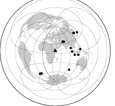
Azimuth Distribution of Events:
Prior Results for this Station
| Study | Thickness | Vp/Vs | Vp | Vs | Poissons Ratio | Extra |
| EARS | 46 km | 1.76 | 6.643 km/s | 3.78 km/s | 0.26 | |
| Crust2.0 | 23 km | 1.77 | 6.643 km/s | 3.757 km/s | 0.26 | IG,very thin late Proter., no seds. |
| Global Maxima | 46 km | 1.76 | 6.643 km/s | 3.78 km/s | 0.26 | amp=0.013301363 |
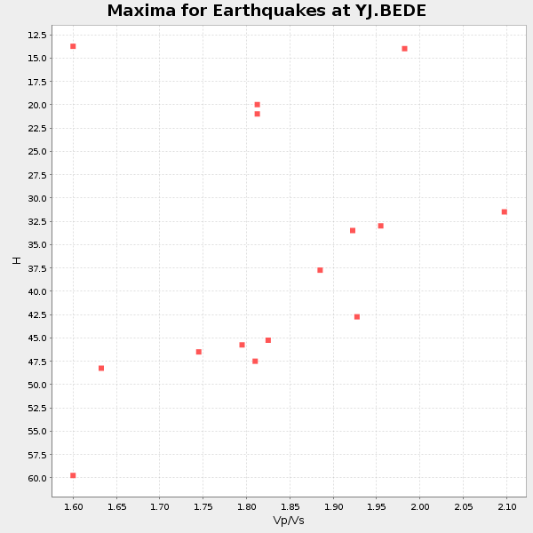
| Local Maxima 1 | 45 km | 1.73 | 6.643 km/s | 3.846 km/s | 0.25 | amp=0.0072730808 |
| Local Maxima 2 | 59 km | 1.60 | 6.643 km/s | 4.146 km/s | 0.18 | amp=0.00670049 |
| Local Maxima 3 | 39 km | 1.91 | 6.643 km/s | 3.474 km/s | 0.31 | amp=0.0065290765 |
| Local Maxima 4 | 33 km | 1.96 | 6.643 km/s | 3.385 km/s | 0.32 | amp=0.0049266634 |
| Predicted Arrivals for vertical incidence (zero ray parameter) | |
| Ps | 5.22 SECOND |
| PpPs | 18.99 SECOND |
| PsPs/PpSs | 24.21 SECOND |
Events Processed for this Station
Download zip of receiver functions as SAC
Plot maxima for each earthquake.
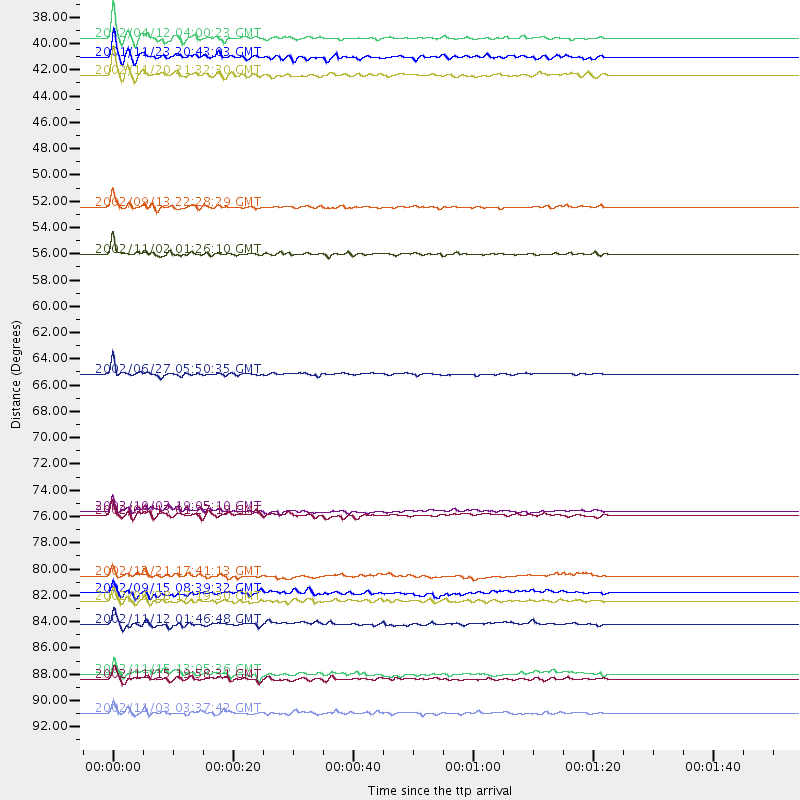
Events Used in the Stack
(15 events)| Radial Match | Distance | Baz | FERegion | Time | Lat/Lon | Depth | Magnitude |
| 96.51212 | 65.1 deg | 101.918 deg | Sunda Strait, Indonesia | 2002/06/27 05:50:35 GMT | (-7.0, 104.2) | 11 km | 6.0 MB, 6.9 MS, 6.6 MW, 6.5 MW |
| 94.46802 | 90.2 deg | 213.165 deg | South Georgia Island Region | 2002/11/15 19:58:31 GMT | (-56.1, -36.4) | 10 km | 6.1 MB, 6.6 MS, 6.7 MW, 6.4 MW |
| 93.906166 | 55.3 deg | 92.725 deg | Northern Sumatra, Indonesia | 2002/11/02 01:26:10 GMT | (2.8, 96.1) | 30 km | 6.2 MB, 7.6 MS, 7.4 MW, 7.4 MW |
| 93.4226 | 37.5 deg | 39.721 deg | Hindu Kush Region, Afghanistan | 2002/04/12 04:00:23 GMT | (36.0, 69.4) | 10 km | 5.8 MB, 5.9 MS, 5.9 MW, 5.7 MW |
| 93.39892 | 85.7 deg | 211.064 deg | South Sandwich Islands Region | 2002/11/12 01:46:48 GMT | (-56.5, -27.5) | 120 km | 6.0 MB, 6.3 MW, 6.2 MW |
| 93.38843 | 76.7 deg | 143.585 deg | Southeast Indian Ridge | 2002/06/13 01:27:19 GMT | (-47.8, 99.8) | 10 km | 5.5 MB, 6.6 MS, 6.6 MW, 6.5 MW |
| 92.287346 | 51.4 deg | 80.447 deg | Andaman Islands, India Region | 2002/09/13 22:28:29 GMT | (13.0, 93.1) | 21 km | 6.2 MB, 6.7 MS, 6.5 MW, 6.5 MW |
| 90.64658 | 76.4 deg | 99.973 deg | Bali Sea | 2002/10/03 19:05:10 GMT | (-7.5, 115.7) | 316 km | 6.0 MB, 6.0 MW, 6.0 MW |
| 90.395294 | 40.5 deg | 44.264 deg | Northwestern Kashmir | 2002/11/20 21:32:30 GMT | (35.4, 74.5) | 33 km | 5.7 MB, 6.5 MS, 6.4 MW, 6.0 MW |
| 88.54005 | 83.8 deg | 46.791 deg | E. Russia-N.E. China Border Reg. | 2002/06/28 17:19:30 GMT | (43.8, 130.7) | 566 km | 6.7 MB, 7.3 MW, 7.3 MW |
| 87.89072 | 39.1 deg | 40.844 deg | Afghanistan-Tajikistan Bord Reg. | 2001/11/23 20:43:03 GMT | (36.4, 71.5) | 106 km | 5.9 MB, 6.1 MW, 6.0 MW |
| 87.64608 | 93.1 deg | 50.056 deg | Near East Coast Of Honshu, Japan | 2002/11/03 03:37:42 GMT | (38.9, 142.0) | 39 km | 5.7 MB, 6.1 MS, 6.4 MW, 6.4 MW |
| 87.64204 | 89.8 deg | 213.39 deg | South Georgia Island Region | 2002/11/15 13:05:36 GMT | (-55.7, -35.8) | 10 km | 5.8 MB, 5.5 MS, 5.8 MW, 5.8 MW |
| 85.37367 | 81.7 deg | 86.237 deg | Celebes Sea | 2002/12/21 17:41:13 GMT | (5.0, 123.2) | 602 km | 5.7 MW, 5.4 MB, 5.7 MW |
| 81.36349 | 83.2 deg | 45.766 deg | Northeastern China | 2002/09/15 08:39:32 GMT | (44.8, 129.9) | 586 km | 5.8 MB, 6.4 MW, 6.4 MW |
Losers
(2 events)| Radial Match | Distance | Baz | FERegion | Time | Lat/Lon | Depth | Magnitude | Reason |
| 79.35796 | 31.4 deg | 333.996 deg | Southern Greece | 2002/05/21 20:53:29 GMT | (36.6, 24.3) | 97 km | 5.4 MB, 5.6 MD | |
| 61.909187 | 77.0 deg | 75.963 deg | Luzon, Philippines | 2003/01/06 23:43:50 GMT | (15.7, 119.7) | 10 km | 5.5 MB, 5.6 MS, 6.0 MW, 5.9 MW |
