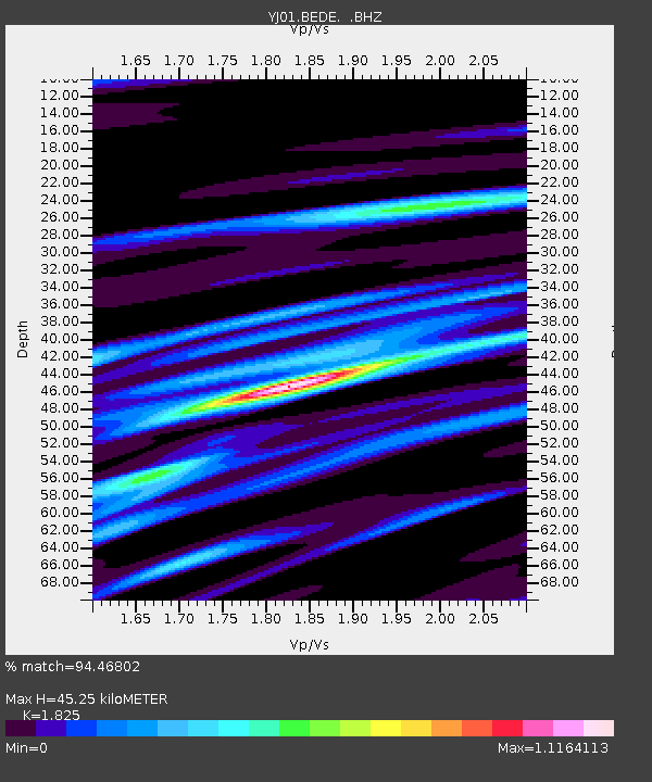
BEDE Bedesa High School - Earthquake Result Viewer

Earthquake location: South Georgia Island Region
Earthquake latitude/longitude: -56.1/-36.4
Earthquake time(UTC): 2002/11/15 (319) 19:58:31 GMT
Earthquake Depth: 10 km
Earthquake Magnitude: 6.1 MB, 6.6 MS, 6.7 MW, 6.4 MW
Earthquake Catalog/Contributor: WHDF/NEIC
Network: YJ Ethiopia-Afar Geoscientific Lithospheric Experiment
Station: BEDE Bedesa High School
Lat/Lon: 8.91 N/40.77 E
Elevation: 1714 m
Distance: 90.2 deg
Az: 74.462 deg
Baz: 213.165 deg
Ray Param: 0.041687038
Estimated Moho Depth: 45.25 km
Estimated Crust Vp/Vs: 1.83
Assumed Crust Vp: 6.643 km/s
Estimated Crust Vs: 3.64 km/s
Estimated Crust Poisson's Ratio: 0.29
Radial Match: 94.46802 %
Radial Bump: 400
Transverse Match: 87.69912 %
Transverse Bump: 400
SOD ConfigId: 16820
Insert Time: 2010-03-09 00:40:39.328 +0000
GWidth: 2.5
Max Bumps: 400
Tol: 0.001

Signal To Noise

ChannelStoNSTALTA
YJ:BEDE: :BHZ:20021115T20:11:00.93802Z0.998440861.11099475E-71.1127297E-7
YJ:BEDE: :BHN:20021115T20:11:00.93802Z1.12116611.2632115E-71.1266944E-7
YJ:BEDE: :BHE:20021115T20:11:00.93802Z1.05181328.740989E-88.3104E-8
Arrivals
Ps5.7 SECOND
PpPs19 SECOND
PsPs/PpSs25 SECOND