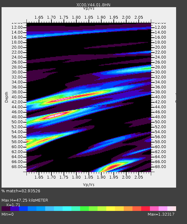
Y44 Y44 - Earthquake Result Viewer
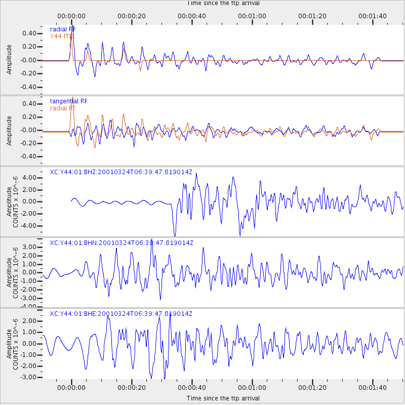
Earthquake location: Western Honshu, Japan
Earthquake latitude/longitude: 34.1/132.5
Earthquake time(UTC): 2001/03/24 (083) 06:27:53 GMT
Earthquake Depth: 50 km
Earthquake Magnitude: 6.4 MB, 6.5 MS, 6.8 MW, 6.4 ME
Earthquake Catalog/Contributor: WHDF/NEIC
Network: XC Yellowstone Intermountain Seismic Array
Station: Y44 Y44
Lat/Lon: 44.10 N/109.19 W
Elevation: 2121 m
Distance: 84.1 deg
Az: 39.632 deg
Baz: 312.708 deg
Ray Param: 0.04566486
Estimated Moho Depth: 47.25 km
Estimated Crust Vp/Vs: 1.71
Assumed Crust Vp: 6.242 km/s
Estimated Crust Vs: 3.65 km/s
Estimated Crust Poisson's Ratio: 0.24
Radial Match: 82.93526 %
Radial Bump: 400
Transverse Match: 81.42074 %
Transverse Bump: 400
SOD ConfigId: 4714
Insert Time: 2010-02-26 15:04:38.809 +0000
GWidth: 2.5
Max Bumps: 400
Tol: 0.001

Signal To Noise

ChannelStoNSTALTA
XC:Y44:01:BHN:20010324T06:39:47.819014Z1.72972064.7588475E-72.7512232E-7
XC:Y44:01:BHE:20010324T06:39:47.819014Z2.38119828.5252526E-73.5802364E-7
XC:Y44:01:BHZ:20010324T06:39:47.819014Z7.88655762.1706896E-62.7523916E-7
Arrivals
Ps5.5 SECOND
PpPs20 SECOND
PsPs/PpSs26 SECOND