
Station XC Y44 - Y44
Network: XC00 - Yellowstone Intermountain Seismic Array
Nearby stations (2 deg radius)
| Station | Name | (Lat, Lon) | Start / End | Elevation |
| Y44 | Y44 | (44.10, -109.19) | 2000-06-20 / 2001-12-31 | 2121 m |
| Crust2 Type: | PD,orogen/50km, Tibet, 2 km seds. |
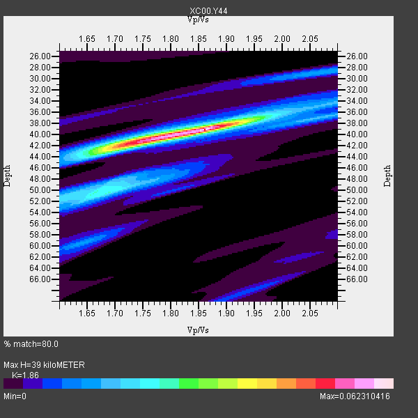
| Thickness Estimate: | 39 km |
| Thickness StdDev: | 2.3 km |
| Vp/Vs Estimate: | 1.86 |
| Vp/Vs StdDev: | 0.06 |
| Vs Estimate: | 3.356 km/s |
| Poisson's Ratio: | 0.30 |
| Peak Value: | 0.06 |
| Assumed Vp: | 6.242 km/s |
| Ps Weight: | 0.33333334 |
| PpPs Weight: | 0.33333334 |
| PsPs Weight: | 0.33333328 |
| Residual Complexity: | 0.555 |
| Nearby stations H: | +- |
| (2.0 deg) Vp/Vs: | +- |
2 with match > 90% ( 25.0 %) and 8 with match > 80% ( 100.0 %) out of 8.
Download stack as xyz text file.
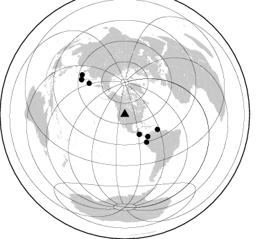
Azimuth Distribution of Events:
Prior Results for this Station
| Study | Thickness | Vp/Vs | Vp | Vs | Poissons Ratio | Extra |
| EARS | 39 km | 1.86 | 6.242 km/s | 3.356 km/s | 0.30 | |
| Crust2.0 | 50 km | 1.76 | 6.242 km/s | 3.546 km/s | 0.26 | PD,orogen/50km, Tibet, 2 km seds. |
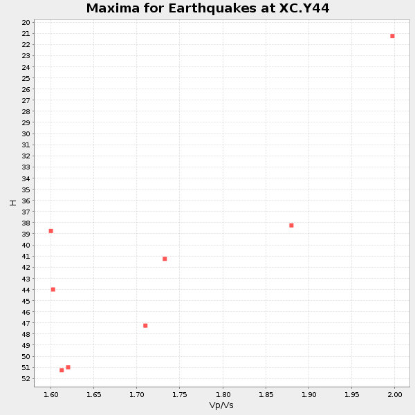
| Global Maxima | 39 km | 1.86 | 6.242 km/s | 3.356 km/s | 0.30 | amp=0.062310416 |
| Local Maxima 1 | 42 km | 1.72 | 6.242 km/s | 3.64 km/s | 0.24 | amp=0.03928413 |
| Local Maxima 2 | 50 km | 1.69 | 6.242 km/s | 3.693 km/s | 0.23 | amp=0.023320576 |
| Local Maxima 3 | 60 km | 1.64 | 6.242 km/s | 3.806 km/s | 0.20 | amp=0.013644457 |
| Local Maxima 4 | 28 km | 2.09 | 6.242 km/s | 2.983 km/s | 0.35 | amp=0.013474002 |
| Predicted Arrivals for vertical incidence (zero ray parameter) | |
| Ps | 5.37 SECOND |
| PpPs | 17.87 SECOND |
| PsPs/PpSs | 23.24 SECOND |
Events Processed for this Station
Download zip of receiver functions as SAC
Plot maxima for each earthquake.
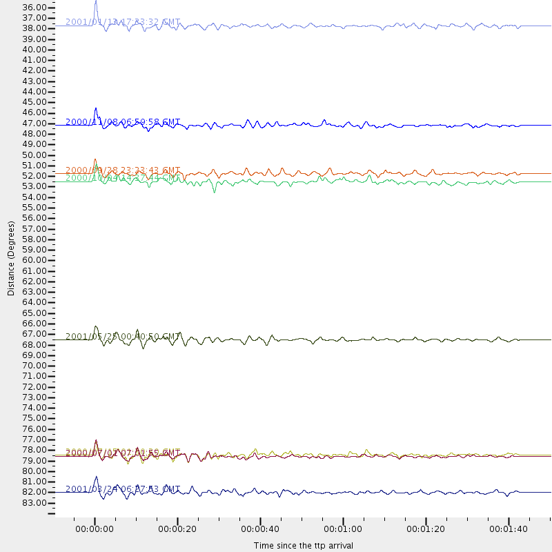
Events Used in the Stack
(8 events)| Radial Match | Distance | Baz | FERegion | Time | Lat/Lon | Depth | Magnitude |
| 91.15563 | 35.6 deg | 144.053 deg | El Salvador | 2001/01/13 17:33:32 GMT | (13.0, -88.7) | 60 km | 6.4 MB, 7.8 MS, 7.7 MW, 7.5 ME |
| 90.29466 | 51.8 deg | 114.777 deg | Windward Islands | 2000/10/04 14:37:44 GMT | (11.1, -62.6) | 110 km | 5.6 MB, 5.4 MS, 6.1 MW, 5.9 MD |
| 87.02504 | 68.2 deg | 310.925 deg | Kuril Islands | 2001/05/25 00:40:50 GMT | (44.3, 148.4) | 33 km | 6.1 MB, 6.7 MS, 6.7 MW, 6.6 MW |
| 86.61461 | 46.0 deg | 134.071 deg | Panama-Colombia Border Region | 2000/11/08 06:59:58 GMT | (7.0, -77.8) | 17 km | 6.0 MB, 6.4 MS, 6.5 MW, 6.2 ML |
| 86.11099 | 80.2 deg | 308.629 deg | Near S. Coast Of Honshu, Japan | 2000/07/15 01:30:30 GMT | (34.3, 139.3) | 10 km | 5.5 MB, 5.9 MS, 6.1 MW, 6.0 MW |
| 85.53241 | 80.3 deg | 308.641 deg | Near S. Coast Of Honshu, Japan | 2000/07/01 07:01:55 GMT | (34.2, 139.1) | 10 km | 6.0 MB, 6.1 MS, 6.2 MW, 6.2 MW |
| 82.93526 | 84.1 deg | 312.708 deg | Western Honshu, Japan | 2001/03/24 06:27:53 GMT | (34.1, 132.5) | 50 km | 6.4 MB, 6.5 MS, 6.8 MW, 6.4 ME |
| 80.11697 | 51.0 deg | 141.941 deg | Near Coast Of Ecuador | 2000/09/28 23:23:43 GMT | (-0.2, -80.6) | 23 km | 5.8 MB, 6.0 MS, 6.6 MW, 6.4 MW |
Losers
(0 events)| Radial Match | Distance | Baz | FERegion | Time | Lat/Lon | Depth | Magnitude | Reason |
