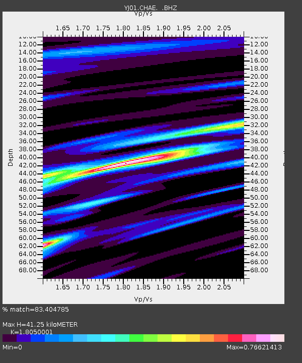
CHAE Chancho High School - Earthquake Result Viewer

Earthquake location: South Sandwich Islands Region
Earthquake latitude/longitude: -57.0/-24.8
Earthquake time(UTC): 2002/12/17 (351) 04:32:53 GMT
Earthquake Depth: 10 km
Earthquake Magnitude: 5.4 MB, 6.3 MS, 6.2 MW, 6.0 MW
Earthquake Catalog/Contributor: WHDF/NEIC
Network: YJ Ethiopia-Afar Geoscientific Lithospheric Experiment
Station: CHAE Chancho High School
Lat/Lon: 9.31 N/38.76 E
Elevation: 2646 m
Distance: 83.9 deg
Az: 62.746 deg
Baz: 209.571 deg
Ray Param: 0.045851734
Estimated Moho Depth: 41.25 km
Estimated Crust Vp/Vs: 1.81
Assumed Crust Vp: 6.464 km/s
Estimated Crust Vs: 3.581 km/s
Estimated Crust Poisson's Ratio: 0.28
Radial Match: 83.404785 %
Radial Bump: 400
Transverse Match: 74.52574 %
Transverse Bump: 400
SOD ConfigId: 16844
Insert Time: 2010-03-09 00:41:22.556 +0000
GWidth: 2.5
Max Bumps: 400
Tol: 0.001

Signal To Noise

ChannelStoNSTALTA
YJ:CHAE: :BHZ:20021217T04:44:51.559014Z0.64076289.313448E-81.4534939E-7
YJ:CHAE: :BHN:20021217T04:44:51.559014Z2.25933811.7073305E-77.556772E-8
YJ:CHAE: :BHE:20021217T04:44:51.559014Z1.34390019.032981E-86.7214685E-8
Arrivals
Ps5.3 SECOND
PpPs17 SECOND
PsPs/PpSs23 SECOND