
Station YJ CHAE - Chancho High School
Network: YJ01 - Ethiopia-Afar Geoscientific Lithospheric Experiment
Nearby stations (2 deg radius)
| Station | Name | (Lat, Lon) | Start / End | Elevation |
| CHAE | Chancho High School | (9.31, 38.76) | 2001-11-19 / 2003-01-18 | 2646 m |
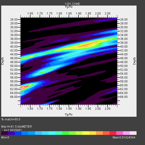
| Crust2 Type: | G9,thin custal Archean 0.1 km seds., South American |
| Thickness Estimate: | 62 km |
| Thickness StdDev: | 11 km |
| Vp/Vs Estimate: | 1.60 |
| Vp/Vs StdDev: | 0.17 |
| Vs Estimate: | 4.033 km/s |
| Poisson's Ratio: | 0.18 |
| Peak Value: | 0.01 |
| Assumed Vp: | 6.464 km/s |
| Ps Weight: | 0.33333334 |
| PpPs Weight: | 0.33333334 |
| PsPs Weight: | 0.33333328 |
| Residual Complexity: | 0.855 |
| Nearby stations H: | +- |
| (2.0 deg) Vp/Vs: | +- |
3 with match > 90% ( 33.333332 %) and 8 with match > 80% ( 88.888885 %) out of 9.
Download stack as xyz text file.
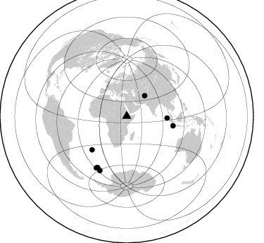
Azimuth Distribution of Events:
Prior Results for this Station
| Study | Thickness | Vp/Vs | Vp | Vs | Poissons Ratio | Extra |
| EARS | 62 km | 1.60 | 6.464 km/s | 4.033 km/s | 0.18 | |
| Crust2.0 | 31 km | 1.76 | 6.464 km/s | 3.663 km/s | 0.26 | G9,thin custal Archean 0.1 km seds., South American |
| Global Maxima | 62 km | 1.60 | 6.464 km/s | 4.033 km/s | 0.18 | amp=0.01424544 |
| Local Maxima 1 | 40 km | 1.94 | 6.464 km/s | 3.327 km/s | 0.32 | amp=0.009595206 |
| Local Maxima 2 | 46 km | 1.64 | 6.464 km/s | 3.941 km/s | 0.20 | amp=0.007725221 |
| Local Maxima 3 | 53 km | 1.73 | 6.464 km/s | 3.736 km/s | 0.25 | amp=0.0065881526 |
| Local Maxima 4 | 40 km | 1.87 | 6.464 km/s | 3.452 km/s | 0.30 | amp=0.006541037 |
| Predicted Arrivals for vertical incidence (zero ray parameter) | |
| Ps | 5.73 SECOND |
| PpPs | 24.76 SECOND |
| PsPs/PpSs | 30.50 SECOND |
Events Processed for this Station
Download zip of receiver functions as SAC
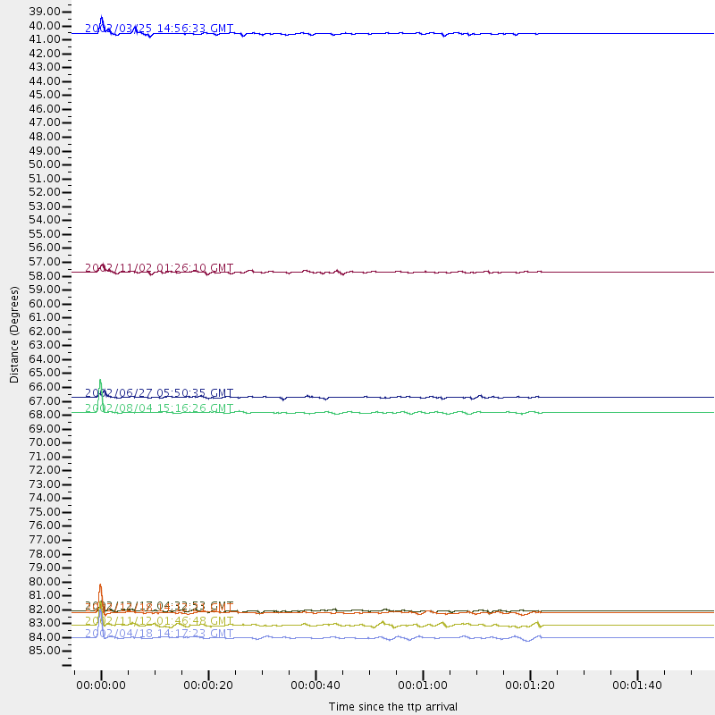
Plot maxima for each earthquake.
Events Used in the Stack
(8 events)| Radial Match | Distance | Baz | FERegion | Time | Lat/Lon | Depth | Magnitude |
| 94.15821 | 68.3 deg | 226.024 deg | Southern Mid-Atlantic Ridge | 2002/08/04 15:16:26 GMT | (-35.5, -16.2) | 10 km | 6.0 MW, 5.3 MS, 5.4 MB, 5.9 MW |
| 92.78776 | 38.5 deg | 41.455 deg | Hindu Kush Region, Afghanistan | 2002/03/25 14:56:33 GMT | (36.1, 69.3) | 8.0 km | 5.9 MB, 6.2 MS, 6.1 MW, 6.0 MW |
| 90.72757 | 57.3 deg | 92.614 deg | Northern Sumatra, Indonesia | 2002/11/02 01:26:10 GMT | (2.8, 96.1) | 30 km | 6.2 MB, 7.6 MS, 7.4 MW, 7.4 MW |
| 89.16446 | 86.1 deg | 206.487 deg | South Sandwich Islands Region | 2002/04/18 14:17:23 GMT | (-60.7, -25.8) | 10 km | 5.7 MB, 5.6 MS, 5.8 MW, 5.7 MW |
| 87.80553 | 84.1 deg | 209.485 deg | South Sandwich Islands Region | 2002/12/18 14:12:21 GMT | (-57.1, -25.0) | 10 km | 5.5 MB, 6.0 MS, 6.2 MW, 5.9 MW |
| 84.94866 | 67.2 deg | 101.596 deg | Sunda Strait, Indonesia | 2002/06/27 05:50:35 GMT | (-7.0, 104.2) | 11 km | 6.0 MB, 6.9 MS, 6.6 MW, 6.5 MW |
| 83.404785 | 83.9 deg | 209.571 deg | South Sandwich Islands Region | 2002/12/17 04:32:53 GMT | (-57.0, -24.8) | 10 km | 5.4 MB, 6.3 MS, 6.2 MW, 6.0 MW |
| 80.80488 | 85.1 deg | 210.594 deg | South Sandwich Islands Region | 2002/11/12 01:46:48 GMT | (-56.5, -27.5) | 120 km | 6.0 MB, 6.3 MW, 6.2 MW |
Losers
(1 events)| Radial Match | Distance | Baz | FERegion | Time | Lat/Lon | Depth | Magnitude | Reason |
| 64.88786 | 81.2 deg | 90.945 deg | Minahassa Peninsula, Sulawesi | 2002/06/16 00:00:25 GMT | (0.5, 119.9) | 35 km | 5.7 MB, 5.5 MS, 5.9 MW, 5.8 MW |
