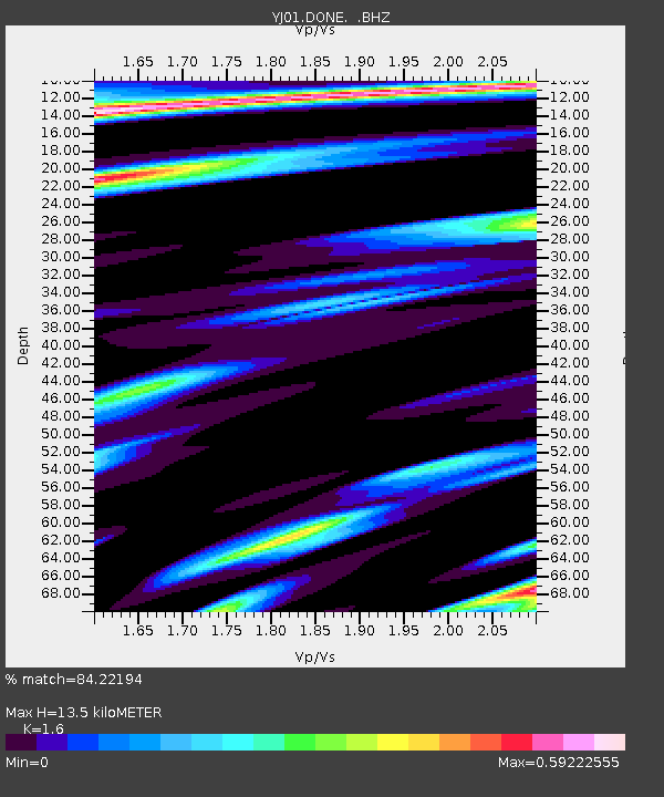
DONE Doni Junior School - Earthquake Result Viewer

Earthquake location: South Sandwich Islands Region
Earthquake latitude/longitude: -57.0/-24.8
Earthquake time(UTC): 2002/12/17 (351) 04:32:53 GMT
Earthquake Depth: 10 km
Earthquake Magnitude: 5.4 MB, 6.3 MS, 6.2 MW, 6.0 MW
Earthquake Catalog/Contributor: WHDF/NEIC
Network: YJ Ethiopia-Afar Geoscientific Lithospheric Experiment
Station: DONE Doni Junior School
Lat/Lon: 8.51 N/39.55 E
Elevation: 1312 m
Distance: 83.6 deg
Az: 63.824 deg
Baz: 209.81 deg
Ray Param: 0.046070814
Estimated Moho Depth: 13.5 km
Estimated Crust Vp/Vs: 1.60
Assumed Crust Vp: 6.464 km/s
Estimated Crust Vs: 4.04 km/s
Estimated Crust Poisson's Ratio: 0.18
Radial Match: 84.22194 %
Radial Bump: 400
Transverse Match: 69.33621 %
Transverse Bump: 400
SOD ConfigId: 16820
Insert Time: 2010-03-09 00:41:39.133 +0000
GWidth: 2.5
Max Bumps: 400
Tol: 0.001

Signal To Noise

ChannelStoNSTALTA
YJ:DONE: :BHZ:20021217T04:44:49.999016Z0.91501171.1734018E-71.28239E-7
YJ:DONE: :BHN:20021217T04:44:49.999016Z1.0275041.3356427E-71.2998906E-7
YJ:DONE: :BHE:20021217T04:44:49.999016Z0.73101281.5421435E-72.1095984E-7
Arrivals
Ps1.3 SECOND
PpPs5.3 SECOND
PsPs/PpSs6.6 SECOND