
Station YJ DONE - Doni Junior School
Network: YJ01 - Ethiopia-Afar Geoscientific Lithospheric Experiment
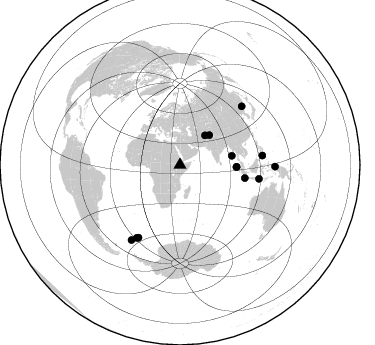
Nearby stations (2 deg radius)
| Station | Name | (Lat, Lon) | Start / End | Elevation |
| DONE | Doni Junior School | (8.51, 39.55) | 2001-11-02 / 2003-01-31 | 1312 m |
| Crust2 Type: | G9,thin custal Archean 0.1 km seds., South American |
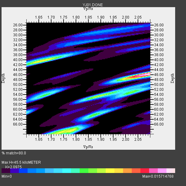
| Thickness Estimate: | 46 km |
| Thickness StdDev: | 9.4 km |
| Vp/Vs Estimate: | 2.10 |
| Vp/Vs StdDev: | 0.17 |
| Vs Estimate: | 3.082 km/s |
| Poisson's Ratio: | 0.35 |
| Peak Value: | 0.02 |
| Assumed Vp: | 6.464 km/s |
| Ps Weight: | 0.33333334 |
| PpPs Weight: | 0.33333334 |
| PsPs Weight: | 0.33333328 |
| Residual Complexity: | 0.787 |
| Nearby stations H: | +- |
| (2.0 deg) Vp/Vs: | +- |
3 with match > 90% ( 21.428572 %) and 13 with match > 80% ( 92.85714 %) out of 14.
Download stack as xyz text file.
Azimuth Distribution of Events:
Prior Results for this Station
| Study | Thickness | Vp/Vs | Vp | Vs | Poissons Ratio | Extra |
| EARS | 46 km | 2.10 | 6.464 km/s | 3.082 km/s | 0.35 | |
| Crust2.0 | 31 km | 1.76 | 6.464 km/s | 3.663 km/s | 0.26 | G9,thin custal Archean 0.1 km seds., South American |
| Global Maxima | 46 km | 2.10 | 6.464 km/s | 3.082 km/s | 0.35 | amp=0.015714768 |
| Local Maxima 1 | 40 km | 1.66 | 6.464 km/s | 3.888 km/s | 0.22 | amp=0.010396862 |
| Local Maxima 2 | 68 km | 1.78 | 6.464 km/s | 3.626 km/s | 0.27 | amp=0.010387773 |
| Local Maxima 3 | 55 km | 1.87 | 6.464 km/s | 3.456 km/s | 0.30 | amp=0.00797398 |
| Local Maxima 4 | 54 km | 1.67 | 6.464 km/s | 3.865 km/s | 0.22 | amp=0.007335728 |
| Predicted Arrivals for vertical incidence (zero ray parameter) | |
| Ps | 7.73 SECOND |
| PpPs | 21.80 SECOND |
| PsPs/PpSs | 29.53 SECOND |
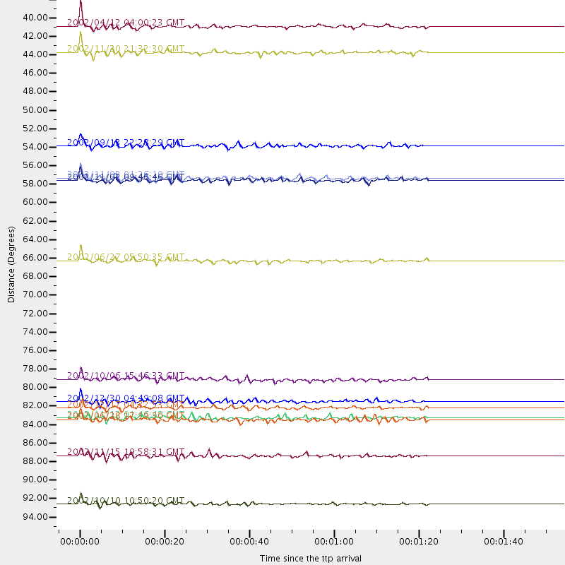
Events Processed for this Station
Download zip of receiver functions as SAC
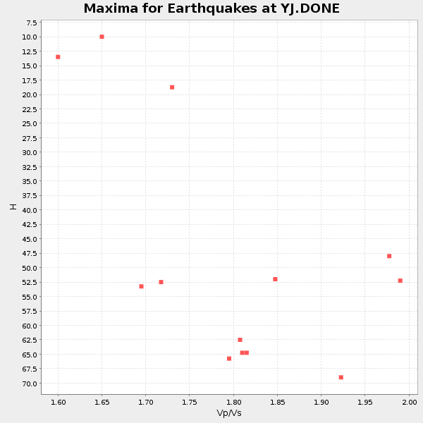
Plot maxima for each earthquake.
Events Used in the Stack
(13 events)| Radial Match | Distance | Baz | FERegion | Time | Lat/Lon | Depth | Magnitude |
| 93.38233 | 56.5 deg | 92.237 deg | Northern Sumatra, Indonesia | 2002/11/02 01:26:10 GMT | (2.8, 96.1) | 30 km | 6.2 MB, 7.6 MS, 7.4 MW, 7.4 MW |
| 92.1332 | 66.2 deg | 101.448 deg | Sunda Strait, Indonesia | 2002/06/27 05:50:35 GMT | (-7.0, 104.2) | 11 km | 6.0 MB, 6.9 MS, 6.6 MW, 6.5 MW |
| 90.17282 | 82.9 deg | 83.51 deg | Mindanao, Philippines | 2002/12/30 04:49:08 GMT | (7.5, 123.4) | 10 km | 5.9 MB, 6.2 MS, 6.3 MW, 6.2 MW |
| 89.943886 | 89.3 deg | 212.977 deg | South Georgia Island Region | 2002/11/15 19:58:31 GMT | (-56.1, -36.4) | 10 km | 6.1 MB, 6.6 MS, 6.7 MW, 6.4 MW |
| 89.90739 | 38.6 deg | 40.392 deg | Hindu Kush Region, Afghanistan | 2002/04/12 04:00:23 GMT | (36.0, 69.4) | 10 km | 5.8 MB, 5.9 MS, 5.9 MW, 5.7 MW |
| 89.806145 | 95.0 deg | 91.033 deg | Irian Jaya Region, Indonesia | 2002/10/10 10:50:20 GMT | (-1.8, 134.3) | 10 km | 6.5 MB, 7.7 MS, 7.6 MW, 7.4 MW |
| 89.50318 | 52.7 deg | 80.117 deg | Andaman Islands, India Region | 2002/09/13 22:28:29 GMT | (13.0, 93.1) | 21 km | 6.2 MB, 6.7 MS, 6.5 MW, 6.5 MW |
| 86.44437 | 84.8 deg | 210.811 deg | South Sandwich Islands Region | 2002/11/12 01:46:48 GMT | (-56.5, -27.5) | 120 km | 6.0 MB, 6.3 MW, 6.2 MW |
| 85.98856 | 80.2 deg | 99.838 deg | Sumbawa Region, Indonesia | 2002/10/06 15:46:33 GMT | (-8.2, 118.3) | 10 km | 5.8 MB, 6.0 MS, 6.2 MW, 6.2 MW |
| 85.94649 | 56.8 deg | 92.031 deg | Northern Sumatra, Indonesia | 2002/11/02 09:46:46 GMT | (3.0, 96.4) | 27 km | 5.9 MB, 6.4 MS, 6.4 MW, 6.1 MW |
| 84.22194 | 83.6 deg | 209.81 deg | South Sandwich Islands Region | 2002/12/17 04:32:53 GMT | (-57.0, -24.8) | 10 km | 5.4 MB, 6.3 MS, 6.2 MW, 6.0 MW |
| 83.90536 | 85.0 deg | 46.66 deg | E. Russia-N.E. China Border Reg. | 2002/06/28 17:19:30 GMT | (43.8, 130.7) | 566 km | 6.7 MB, 7.3 MW, 7.3 MW |
| 83.118866 | 41.7 deg | 44.748 deg | Northwestern Kashmir | 2002/11/20 21:32:30 GMT | (35.4, 74.5) | 33 km | 5.7 MB, 6.5 MS, 6.4 MW, 6.0 MW |
Losers
(1 events)| Radial Match | Distance | Baz | FERegion | Time | Lat/Lon | Depth | Magnitude | Reason |
| 51.84556 | 94.7 deg | 90.785 deg | Irian Jaya Region, Indonesia | 2002/10/10 21:19:58 GMT | (-1.5, 134.1) | 10 km | 5.8 MB, 5.7 MS, 6.0 MW |
