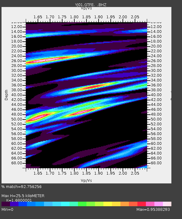
GTFE Gudina Tumsa Foundation School - Earthquake Result Viewer

Earthquake location: South Georgia Island Region
Earthquake latitude/longitude: -56.1/-36.4
Earthquake time(UTC): 2002/11/15 (319) 19:58:31 GMT
Earthquake Depth: 10 km
Earthquake Magnitude: 6.1 MB, 6.6 MS, 6.7 MW, 6.4 MW
Earthquake Catalog/Contributor: WHDF/NEIC
Network: YJ Ethiopia-Afar Geoscientific Lithospheric Experiment
Station: GTFE Gudina Tumsa Foundation School
Lat/Lon: 9.00 N/39.84 E
Elevation: 1036 m
Distance: 89.8 deg
Az: 73.638 deg
Baz: 213.021 deg
Ray Param: 0.041717324
Estimated Moho Depth: 25.5 km
Estimated Crust Vp/Vs: 1.68
Assumed Crust Vp: 6.464 km/s
Estimated Crust Vs: 3.847 km/s
Estimated Crust Poisson's Ratio: 0.23
Radial Match: 92.756256 %
Radial Bump: 400
Transverse Match: 87.76324 %
Transverse Bump: 400
SOD ConfigId: 16820
Insert Time: 2010-03-09 00:42:38.937 +0000
GWidth: 2.5
Max Bumps: 400
Tol: 0.001

Signal To Noise

ChannelStoNSTALTA
YJ:GTFE: :BHZ:20021115T20:10:58.980012Z0.650510851.3560393E-72.084576E-7
YJ:GTFE: :BHN:20021115T20:10:58.980012Z1.24366921.8313497E-71.4725377E-7
YJ:GTFE: :BHE:20021115T20:10:58.980012Z1.15883091.14217166E-79.856241E-8
Arrivals
Ps2.7 SECOND
PpPs10 SECOND
PsPs/PpSs13 SECOND