
Station YJ GTFE - Gudina Tumsa Foundation School
Network: YJ01 - Ethiopia-Afar Geoscientific Lithospheric Experiment
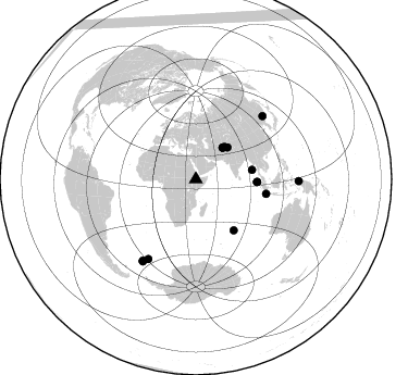
Nearby stations (2 deg radius)
| Station | Name | (Lat, Lon) | Start / End | Elevation |
| GTFE | Gudina Tumsa Foundation School | (9.00, 39.84) | 2001-11-01 / 2003-01-25 | 1036 m |
| Crust2 Type: | G9,thin custal Archean 0.1 km seds., South American |
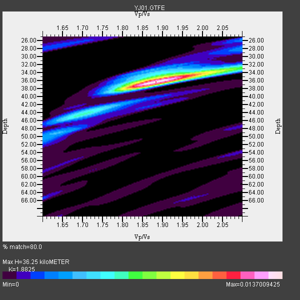
| Thickness Estimate: | 36 km |
| Thickness StdDev: | 3.4 km |
| Vp/Vs Estimate: | 1.88 |
| Vp/Vs StdDev: | 0.08 |
| Vs Estimate: | 3.433 km/s |
| Poisson's Ratio: | 0.30 |
| Peak Value: | 0.01 |
| Assumed Vp: | 6.464 km/s |
| Ps Weight: | 0.33333334 |
| PpPs Weight: | 0.33333334 |
| PsPs Weight: | 0.33333328 |
| Residual Complexity: | 0.381 |
| Nearby stations H: | +- |
| (2.0 deg) Vp/Vs: | +- |
6 with match > 90% ( 40.0 %) and 14 with match > 80% ( 93.333336 %) out of 15.
Download stack as xyz text file.
Azimuth Distribution of Events:
Prior Results for this Station
| Study | Thickness | Vp/Vs | Vp | Vs | Poissons Ratio | Extra |
| EARS | 36 km | 1.88 | 6.464 km/s | 3.433 km/s | 0.30 | |
| Crust2.0 | 31 km | 1.76 | 6.464 km/s | 3.663 km/s | 0.26 | G9,thin custal Archean 0.1 km seds., South American |
| Global Maxima | 36 km | 1.88 | 6.464 km/s | 3.433 km/s | 0.30 | amp=0.0137009425 |
| Local Maxima 1 | 33 km | 2.07 | 6.464 km/s | 3.122 km/s | 0.35 | amp=0.0048014782 |
| Local Maxima 2 | 45 km | 1.68 | 6.464 km/s | 3.842 km/s | 0.23 | amp=0.004575183 |
| Local Maxima 3 | 34 km | 1.85 | 6.464 km/s | 3.499 km/s | 0.29 | amp=0.0027652793 |
| Local Maxima 4 | 49 km | 1.62 | 6.464 km/s | 3.996 km/s | 0.19 | amp=0.002382585 |
| Predicted Arrivals for vertical incidence (zero ray parameter) | |
| Ps | 4.95 SECOND |
| PpPs | 16.17 SECOND |
| PsPs/PpSs | 21.12 SECOND |
Events Processed for this Station
Download zip of receiver functions as SAC
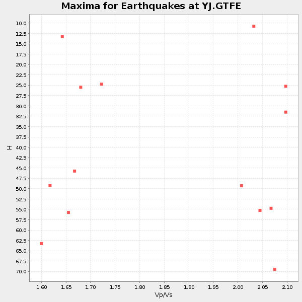
Plot maxima for each earthquake.
Events Used in the Stack
(14 events)| Radial Match | Distance | Baz | FERegion | Time | Lat/Lon | Depth | Magnitude |
| 92.756256 | 89.8 deg | 213.021 deg | South Georgia Island Region | 2002/11/15 19:58:31 GMT | (-56.1, -36.4) | 10 km | 6.1 MB, 6.6 MS, 6.7 MW, 6.4 MW |
| 91.905716 | 52.3 deg | 80.495 deg | Andaman Islands, India Region | 2002/09/13 22:28:29 GMT | (13.0, 93.1) | 21 km | 6.2 MB, 6.7 MS, 6.5 MW, 6.5 MW |
| 91.84657 | 94.7 deg | 91.035 deg | Irian Jaya Region, Indonesia | 2002/10/10 10:50:20 GMT | (-1.8, 134.3) | 10 km | 6.5 MB, 7.7 MS, 7.6 MW, 7.4 MW |
| 91.82525 | 38.0 deg | 40.352 deg | Hindu Kush Region, Afghanistan | 2002/03/25 14:56:33 GMT | (36.1, 69.3) | 8.0 km | 5.9 MB, 6.2 MS, 6.1 MW, 6.0 MW |
| 90.59116 | 56.2 deg | 92.615 deg | Northern Sumatra, Indonesia | 2002/11/02 01:26:10 GMT | (2.8, 96.1) | 30 km | 6.2 MB, 7.6 MS, 7.4 MW, 7.4 MW |
| 90.06484 | 66.1 deg | 101.729 deg | Sunda Strait, Indonesia | 2002/06/27 05:50:35 GMT | (-7.0, 104.2) | 11 km | 6.0 MB, 6.9 MS, 6.6 MW, 6.5 MW |
| 88.00066 | 85.4 deg | 210.854 deg | South Sandwich Islands Region | 2002/11/12 01:46:48 GMT | (-56.5, -27.5) | 120 km | 6.0 MB, 6.3 MW, 6.2 MW |
| 87.70515 | 38.0 deg | 40.566 deg | Hindu Kush Region, Afghanistan | 2002/04/12 04:00:23 GMT | (36.0, 69.4) | 10 km | 5.8 MB, 5.9 MS, 5.9 MW, 5.7 MW |
| 85.82828 | 58.3 deg | 143.339 deg | Mid-Indian Ridge | 2002/05/14 16:56:10 GMT | (-36.5, 78.9) | 10 km | 5.6 MB, 6.1 MS, 6.3 MW, 6.1 MW |
| 85.57352 | 89.4 deg | 213.24 deg | South Georgia Island Region | 2002/11/15 13:05:36 GMT | (-55.7, -35.8) | 10 km | 5.8 MB, 5.5 MS, 5.8 MW, 5.8 MW |
| 85.43017 | 84.4 deg | 46.719 deg | E. Russia-N.E. China Border Reg. | 2002/06/28 17:19:30 GMT | (43.8, 130.7) | 566 km | 6.7 MB, 7.3 MW, 7.3 MW |
| 84.97233 | 41.1 deg | 44.956 deg | Northwestern Kashmir | 2002/11/20 21:32:30 GMT | (35.4, 74.5) | 33 km | 5.7 MB, 6.5 MS, 6.4 MW, 6.0 MW |
| 84.03224 | 39.6 deg | 41.621 deg | Afghanistan-Tajikistan Bord Reg. | 2001/11/23 20:43:03 GMT | (36.4, 71.5) | 106 km | 5.9 MB, 6.1 MW, 6.0 MW |
| 83.47828 | 56.5 deg | 92.405 deg | Northern Sumatra, Indonesia | 2002/11/02 09:46:46 GMT | (3.0, 96.4) | 27 km | 5.9 MB, 6.4 MS, 6.4 MW, 6.1 MW |
Losers
(1 events)| Radial Match | Distance | Baz | FERegion | Time | Lat/Lon | Depth | Magnitude | Reason |
| 71.778145 | 30.9 deg | 335.162 deg | Southern Greece | 2002/05/21 20:53:29 GMT | (36.6, 24.3) | 97 km | 5.4 MB, 5.6 MD |
