You are here: Home > Network List > XC00 - Yellowstone Intermountain Seismic Array Stations List
> Station Y20 Y20 > Earthquake Result Viewer
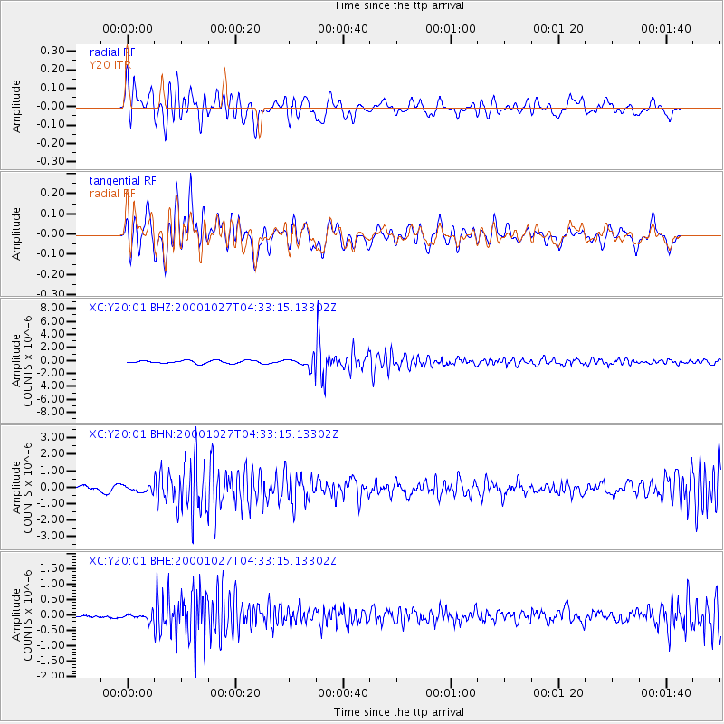
Y20 Y20 - Earthquake Result Viewer

| Earthquake location: |
Bonin Islands, Japan Region |
| Earthquake latitude/longitude: |
26.3/140.5 |
| Earthquake time(UTC): |
2000/10/27 (301) 04:21:51 GMT |
| Earthquake Depth: |
388 km |
| Earthquake Magnitude: |
6.1 MB, 6.1 MW, 6.0 MW |
| Earthquake Catalog/Contributor: |
WHDF/NEIC |
|
| Network: |
XC Yellowstone Intermountain Seismic Array |
| Station: |
Y20 Y20 |
| Lat/Lon: |
43.17 N/110.00 W |
| Elevation: |
2357 m |
|
| Distance: |
85.4 deg |
| Az: |
43.762 deg |
| Baz: |
301.904 deg |
| Ray Param: |
0.043783236 |
| Estimated Moho Depth: |
10.0 km |
| Estimated Crust Vp/Vs: |
1.72 |
| Assumed Crust Vp: |
6.161 km/s |
| Estimated Crust Vs: |
3.577 km/s |
| Estimated Crust Poisson's Ratio: |
0.25 |
|
| Radial Match: |
80.34013 % |
| Radial Bump: |
400 |
| Transverse Match: |
75.31866 % |
| Transverse Bump: |
400 |
| SOD ConfigId: |
16820 |
| Insert Time: |
2010-02-26 15:04:43.884 +0000 |
| GWidth: |
2.5 |
| Max Bumps: |
400 |
| Tol: |
0.001 |
|
Signal To Noise
| Channel | StoN | STA | LTA |
| XC:Y20:01:BHN:20001027T04:33:15.13302Z | 0.92847586 | 1.8413152E-7 | 1.9831589E-7 |
| XC:Y20:01:BHE:20001027T04:33:15.13302Z | 1.5070698 | 9.8707744E-8 | 6.5496465E-8 |
| XC:Y20:01:BHZ:20001027T04:33:15.13302Z | 3.3978832 | 7.445158E-7 | 2.1911164E-7 |
| Arrivals |
| Ps | 1.2 SECOND |
| PpPs | 4.3 SECOND |
| PsPs/PpSs | 5.5 SECOND |


