
Station XC Y20 - Y20
Network: XC00 - Yellowstone Intermountain Seismic Array
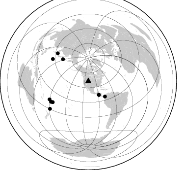
Nearby stations (2 deg radius)
| Station | Name | (Lat, Lon) | Start / End | Elevation |
| Y20 | Y20 | (43.17, -110.00) | 2000-07-06 / 2001-12-31 | 2357 m |
| Crust2 Type: | Q0,orogen/46km no ice, Rockies, Tarim Basin, 4 km seds. |
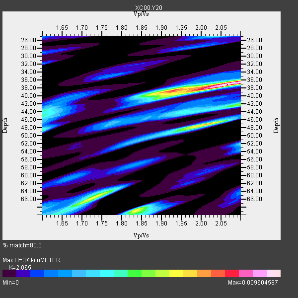
| Thickness Estimate: | 37 km |
| Thickness StdDev: | 13 km |
| Vp/Vs Estimate: | 2.07 |
| Vp/Vs StdDev: | 0.14 |
| Vs Estimate: | 2.983 km/s |
| Poisson's Ratio: | 0.35 |
| Peak Value: | 0.01 |
| Assumed Vp: | 6.161 km/s |
| Ps Weight: | 0.33333334 |
| PpPs Weight: | 0.33333334 |
| PsPs Weight: | 0.33333328 |
| Residual Complexity: | 0.741 |
| Nearby stations H: | +- |
| (2.0 deg) Vp/Vs: | +- |
3 with match > 90% ( 30.0 %) and 10 with match > 80% ( 100.0 %) out of 10.
Download stack as xyz text file.
Azimuth Distribution of Events:
Prior Results for this Station
| Study | Thickness | Vp/Vs | Vp | Vs | Poissons Ratio | Extra |
| EARS | 37 km | 2.07 | 6.161 km/s | 2.983 km/s | 0.35 | |
| Crust2.0 | 46 km | 1.75 | 6.161 km/s | 3.511 km/s | 0.26 | Q0,orogen/46km no ice, Rockies, Tarim Basin, 4 km seds. |
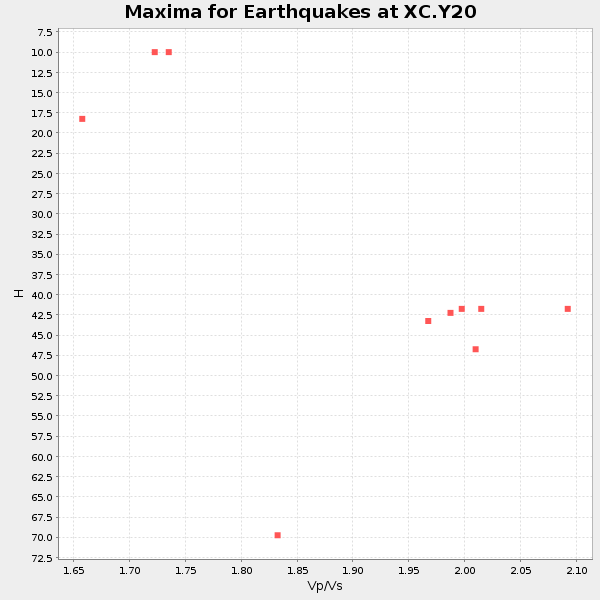
| Global Maxima | 37 km | 2.07 | 6.161 km/s | 2.983 km/s | 0.35 | amp=0.009604587 |
| Local Maxima 1 | 47 km | 2.01 | 6.161 km/s | 3.065 km/s | 0.34 | amp=0.0068539795 |
| Local Maxima 2 | 69 km | 1.84 | 6.161 km/s | 3.357 km/s | 0.29 | amp=0.0060218275 |
| Local Maxima 3 | 66 km | 1.73 | 6.161 km/s | 3.566 km/s | 0.25 | amp=0.005834666 |
| Local Maxima 4 | 38 km | 1.93 | 6.161 km/s | 3.192 km/s | 0.32 | amp=0.00496793 |
| Predicted Arrivals for vertical incidence (zero ray parameter) | |
| Ps | 6.40 SECOND |
| PpPs | 18.41 SECOND |
| PsPs/PpSs | 24.80 SECOND |
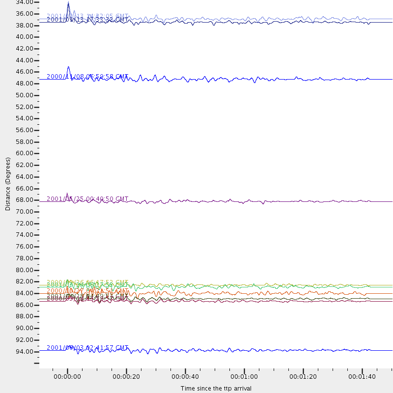
Events Processed for this Station
Download zip of receiver functions as SAC
Plot maxima for each earthquake.
Events Used in the Stack
(10 events)| Radial Match | Distance | Baz | FERegion | Time | Lat/Lon | Depth | Magnitude |
| 95.54266 | 35.2 deg | 142.054 deg | El Salvador | 2001/01/13 17:33:32 GMT | (13.0, -88.7) | 60 km | 6.4 MB, 7.8 MS, 7.7 MW, 7.5 ME |
| 92.84127 | 83.8 deg | 239.731 deg | Tonga Islands | 2000/09/26 06:17:52 GMT | (-17.2, -173.9) | 56 km | 6.1 MB, 6.1 MS, 6.4 MW, 6.1 ME |
| 91.59819 | 96.0 deg | 234.582 deg | Kermadec Islands, New Zealand | 2001/06/03 02:41:57 GMT | (-29.7, -178.6) | 178 km | 6.8 MB, 7.2 MW, 7.1 MW |
| 86.25936 | 68.4 deg | 310.802 deg | Kuril Islands | 2001/05/25 00:40:50 GMT | (44.3, 148.4) | 33 km | 6.1 MB, 6.7 MS, 6.7 MW, 6.6 MW |
| 86.07026 | 45.8 deg | 132.47 deg | Panama-Colombia Border Region | 2000/11/08 06:59:58 GMT | (7.0, -77.8) | 17 km | 6.0 MB, 6.4 MS, 6.5 MW, 6.2 ML |
| 84.118286 | 84.3 deg | 312.264 deg | Western Honshu, Japan | 2001/03/24 06:27:53 GMT | (34.1, 132.5) | 50 km | 6.4 MB, 6.5 MS, 6.8 MW, 6.4 ME |
| 83.57364 | 34.5 deg | 141.973 deg | El Salvador | 2001/02/13 14:22:05 GMT | (13.7, -88.9) | 10 km | 5.5 MB, 6.5 MS, 6.6 MW, 6.1 MD |
| 82.93727 | 86.4 deg | 241.285 deg | Fiji Islands Region | 2001/04/28 04:49:53 GMT | (-18.1, -176.9) | 352 km | 6.2 MB, 6.8 MW, 6.8 MW |
| 81.64269 | 86.9 deg | 245.151 deg | Fiji Islands | 2000/09/14 14:59:57 GMT | (-15.7, 179.8) | 33 km | 5.7 MB, 6.2 MS, 6.3 MW, 6.2 MW |
| 80.34013 | 85.4 deg | 301.904 deg | Bonin Islands, Japan Region | 2000/10/27 04:21:51 GMT | (26.3, 140.5) | 388 km | 6.1 MB, 6.1 MW, 6.0 MW |
Losers
(0 events)| Radial Match | Distance | Baz | FERegion | Time | Lat/Lon | Depth | Magnitude | Reason |
