You are here: Home > Network List > YJ01 - Ethiopia-Afar Geoscientific Lithospheric Experiment Stations List
> Station INEE Inewari High School > Earthquake Result Viewer
INEE Inewari High School - Earthquake Result Viewer
| Earthquake location: |
E. Russia-N.E. China Border Reg. |
| Earthquake latitude/longitude: |
43.8/130.7 |
| Earthquake time(UTC): |
2002/06/28 (179) 17:19:30 GMT |
| Earthquake Depth: |
566 km |
| Earthquake Magnitude: |
6.7 MB, 7.3 MW, 7.3 MW |
| Earthquake Catalog/Contributor: |
WHDF/NEIC |
|
| Network: |
YJ Ethiopia-Afar Geoscientific Lithospheric Experiment |
| Station: |
INEE Inewari High School |
| Lat/Lon: |
9.90 N/39.14 E |
| Elevation: |
2686 m |
|
| Distance: |
84.3 deg |
| Az: |
278.19 deg |
| Baz: |
46.715 deg |
| Ray Param: |
0.04390848 |
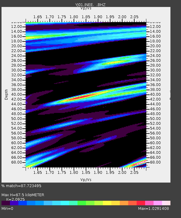
| Estimated Moho Depth: |
67.5 km |
| Estimated Crust Vp/Vs: |
2.09 |
| Assumed Crust Vp: |
6.464 km/s |
| Estimated Crust Vs: |
3.089 km/s |
| Estimated Crust Poisson's Ratio: |
0.35 |
|
| Radial Match: |
87.723495 % |
| Radial Bump: |
400 |
| Transverse Match: |
75.717255 % |
| Transverse Bump: |
400 |
| SOD ConfigId: |
16820 |
| Insert Time: |
2010-03-09 00:43:03.233 +0000 |
| GWidth: |
2.5 |
| Max Bumps: |
400 |
| Tol: |
0.001 |
|

Signal To Noise
| Channel | StoN | STA | LTA |
| YJ:INEE: :BHZ:20020628T17:30:31.960002Z | 1.0382723 | 2.971863E-7 | 2.8623157E-7 |
| YJ:INEE: :BHN:20020628T17:30:31.960002Z | 1.0797406 | 1.9823867E-7 | 1.8359843E-7 |
| YJ:INEE: :BHE:20020628T17:30:31.960002Z | 10.473435 | 1.0983869E-6 | 1.048736E-7 |
| Arrivals |
| Ps | 12 SECOND |
| PpPs | 32 SECOND |
| PsPs/PpSs | 43 SECOND |


