
Station YJ INEE - Inewari High School
Network: YJ01 - Ethiopia-Afar Geoscientific Lithospheric Experiment
Nearby stations (2 deg radius)
| Station | Name | (Lat, Lon) | Start / End | Elevation |
| INEE | Inewari High School | (9.90, 39.14) | 2001-10-23 / 2003-01-29 | 2686 m |
| Crust2 Type: | G9,thin custal Archean 0.1 km seds., South American |
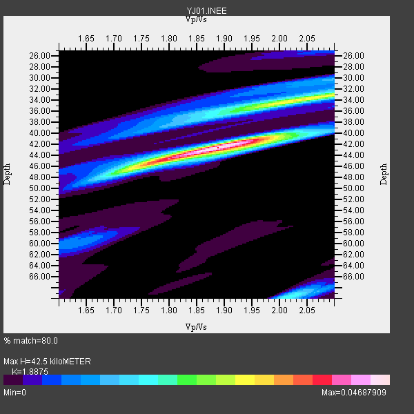
| Thickness Estimate: | 42 km |
| Thickness StdDev: | 7.8 km |
| Vp/Vs Estimate: | 1.89 |
| Vp/Vs StdDev: | 0.09 |
| Vs Estimate: | 3.424 km/s |
| Poisson's Ratio: | 0.30 |
| Peak Value: | 0.05 |
| Assumed Vp: | 6.464 km/s |
| Ps Weight: | 0.33333334 |
| PpPs Weight: | 0.33333334 |
| PsPs Weight: | 0.33333328 |
| Residual Complexity: | 0.622 |
| Nearby stations H: | +- |
| (2.0 deg) Vp/Vs: | +- |
3 with match > 90% ( 37.5 %) and 5 with match > 80% ( 62.5 %) out of 8.
Download stack as xyz text file.
Azimuth Distribution of Events:

Prior Results for this Station
| Study | Thickness | Vp/Vs | Vp | Vs | Poissons Ratio | Extra |
| EARS | 42 km | 1.89 | 6.464 km/s | 3.424 km/s | 0.30 | |
| Crust2.0 | 31 km | 1.76 | 6.464 km/s | 3.663 km/s | 0.26 | G9,thin custal Archean 0.1 km seds., South American |
| Global Maxima | 42 km | 1.89 | 6.464 km/s | 3.424 km/s | 0.30 | amp=0.04687909 |
| Local Maxima 1 | 33 km | 2.07 | 6.464 km/s | 3.126 km/s | 0.35 | amp=0.0284637 |
| Local Maxima 2 | 46 km | 1.75 | 6.464 km/s | 3.699 km/s | 0.26 | amp=0.024057163 |
| Local Maxima 3 | 70 km | 2.02 | 6.464 km/s | 3.204 km/s | 0.34 | amp=0.018482978 |
| Local Maxima 4 | 36 km | 1.90 | 6.464 km/s | 3.397 km/s | 0.31 | amp=0.014163626 |
| Predicted Arrivals for vertical incidence (zero ray parameter) | |
| Ps | 5.84 SECOND |
| PpPs | 18.99 SECOND |
| PsPs/PpSs | 24.82 SECOND |
Events Processed for this Station
Download zip of receiver functions as SAC
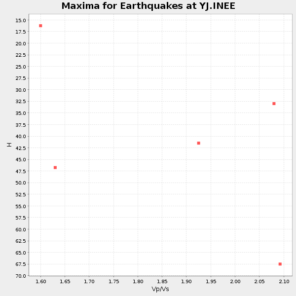
Plot maxima for each earthquake.
Events Used in the Stack
(5 events)| Radial Match | Distance | Baz | FERegion | Time | Lat/Lon | Depth | Magnitude |
| 94.35931 | 66.9 deg | 101.932 deg | Sunda Strait, Indonesia | 2002/06/27 05:50:35 GMT | (-7.0, 104.2) | 11 km | 6.0 MB, 6.9 MS, 6.6 MW, 6.5 MW |
| 93.982185 | 57.0 deg | 93.063 deg | Northern Sumatra, Indonesia | 2002/11/02 01:26:10 GMT | (2.8, 96.1) | 30 km | 6.2 MB, 7.6 MS, 7.4 MW, 7.4 MW |
| 92.640945 | 52.9 deg | 81.135 deg | Andaman Islands, India Region | 2002/09/13 22:28:29 GMT | (13.0, 93.1) | 21 km | 6.2 MB, 6.7 MS, 6.5 MW, 6.5 MW |
| 87.723495 | 84.3 deg | 46.715 deg | E. Russia-N.E. China Border Reg. | 2002/06/28 17:19:30 GMT | (43.8, 130.7) | 566 km | 6.7 MB, 7.3 MW, 7.3 MW |
| 84.34199 | 84.6 deg | 209.638 deg | South Sandwich Islands Region | 2002/12/17 04:32:53 GMT | (-57.0, -24.8) | 10 km | 5.4 MB, 6.3 MS, 6.2 MW, 6.0 MW |
Losers
(3 events)| Radial Match | Distance | Baz | FERegion | Time | Lat/Lon | Depth | Magnitude | Reason |
| 57.71997 | 93.7 deg | 49.687 deg | Near East Coast Of Honshu, Japan | 2002/11/03 03:37:42 GMT | (38.9, 142.0) | 39 km | 5.7 MB, 6.1 MS, 6.4 MW, 6.4 MW | |
| 48.553 | 68.6 deg | 142.692 deg | Southeast Indian Ridge | 2002/10/08 01:23:58 GMT | (-42.0, 88.4) | 10 km | 5.3 MB, 5.7 MS, 6.0 MW, 5.9 MW | |
| 45.0669 | 69.0 deg | 226.026 deg | Southern Mid-Atlantic Ridge | 2002/08/04 15:16:26 GMT | (-35.5, -16.2) | 10 km | 6.0 MW, 5.3 MS, 5.4 MB, 5.9 MW |
