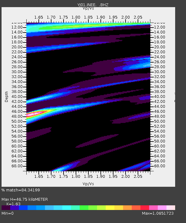
INEE Inewari High School - Earthquake Result Viewer

Earthquake location: South Sandwich Islands Region
Earthquake latitude/longitude: -57.0/-24.8
Earthquake time(UTC): 2002/12/17 (351) 04:32:53 GMT
Earthquake Depth: 10 km
Earthquake Magnitude: 5.4 MB, 6.3 MS, 6.2 MW, 6.0 MW
Earthquake Catalog/Contributor: WHDF/NEIC
Network: YJ Ethiopia-Afar Geoscientific Lithospheric Experiment
Station: INEE Inewari High School
Lat/Lon: 9.90 N/39.14 E
Elevation: 2686 m
Distance: 84.6 deg
Az: 62.786 deg
Baz: 209.638 deg
Ray Param: 0.045366794
Estimated Moho Depth: 46.75 km
Estimated Crust Vp/Vs: 1.63
Assumed Crust Vp: 6.464 km/s
Estimated Crust Vs: 3.965 km/s
Estimated Crust Poisson's Ratio: 0.20
Radial Match: 84.34199 %
Radial Bump: 400
Transverse Match: 22.747137 %
Transverse Bump: 400
SOD ConfigId: 16844
Insert Time: 2010-03-09 00:43:09.883 +0000
GWidth: 2.5
Max Bumps: 400
Tol: 0.001

Signal To Noise

ChannelStoNSTALTA
YJ:INEE: :BHZ:20021217T04:44:55.059014Z0.648464864.517671E-86.9667166E-8
YJ:INEE: :BHN:20021217T04:44:55.059014Z2.35678343.8936946E-71.6521223E-7
YJ:INEE: :BHE:20021217T04:44:55.059014Z1.30258195.1250055E-73.934498E-7
Arrivals
Ps4.7 SECOND
PpPs19 SECOND
PsPs/PpSs23 SECOND