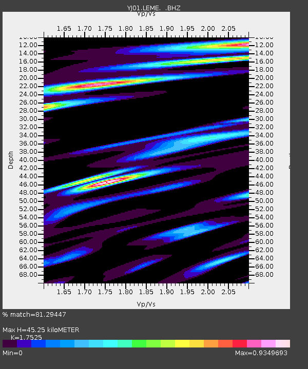
LEME Lemen High School - Earthquake Result Viewer

Earthquake location: Southeast Indian Ridge
Earthquake latitude/longitude: -47.8/99.8
Earthquake time(UTC): 2002/06/13 (164) 01:27:19 GMT
Earthquake Depth: 10 km
Earthquake Magnitude: 5.5 MB, 6.6 MS, 6.6 MW, 6.5 MW
Earthquake Catalog/Contributor: WHDF/NEIC
Network: YJ Ethiopia-Afar Geoscientific Lithospheric Experiment
Station: LEME Lemen High School
Lat/Lon: 8.61 N/38.61 E
Elevation: 2108 m
Distance: 77.8 deg
Az: 297.601 deg
Baz: 142.83 deg
Ray Param: 0.050099373
Estimated Moho Depth: 45.25 km
Estimated Crust Vp/Vs: 1.75
Assumed Crust Vp: 6.464 km/s
Estimated Crust Vs: 3.688 km/s
Estimated Crust Poisson's Ratio: 0.26
Radial Match: 81.29447 %
Radial Bump: 400
Transverse Match: 72.07561 %
Transverse Bump: 400
SOD ConfigId: 16820
Insert Time: 2010-03-09 00:43:38.290 +0000
GWidth: 2.5
Max Bumps: 400
Tol: 0.001

Signal To Noise

ChannelStoNSTALTA
YJ:LEME: :BHZ:20020613T01:38:45.259001Z0.938262342.0445582E-72.17909E-7
YJ:LEME: :BHN:20020613T01:38:45.259001Z0.746867361.5315801E-72.0506721E-7
YJ:LEME: :BHE:20020613T01:38:45.259001Z1.73209862.5305394E-71.4609674E-7
Arrivals
Ps5.4 SECOND
PpPs19 SECOND
PsPs/PpSs24 SECOND